
Earth's Shifting Stage: How Active Tectonics Sculpt Our Rivers
Unveiling the dynamic dance between deep Earth forces and the flowing waters that shape our landscapes, with visual insights.
Highlights of Tectonic Influence
- Dynamic Reshaping: Active tectonic processes like uplift, subsidence, and faulting continuously alter river gradients, courses, and sediment loads, leading to dramatic landscape evolution.
- Geomorphic Fingerprints: Features such as knickpoints (abrupt changes in river slope), incised meanders, river terraces, and offset channels serve as clear indicators of underlying tectonic activity.
- Complex Interactions: The response of fluvial systems to tectonics is multifaceted, influenced by the type and rate of tectonic movement, climate, and the river system's inherent characteristics, leading to varied response times and landscape expressions.
Understanding the Interplay: Active Tectonics and Fluvial Systems
Fluvial systems, encompassing rivers, streams, and their associated landforms, are powerful agents of landscape change, tirelessly eroding, transporting, and depositing sediment. However, they are not solitary actors. Beneath the surface, active tectonics – ongoing geological processes such as faulting, folding, uplift, and subsidence – exert a profound influence, dictating the very stage upon which rivers perform their work. This dynamic interplay shapes the Earth's topography, creating a diverse array of fluvial landscapes that record a history of geological unrest and adaptation.
When tectonic forces deform the Earth's crust, they directly impact the fundamental characteristics of river systems. The gradient (slope) of a river channel, its base level (the lowest point to which it can erode), its path, and its capacity to carry sediment are all subject to tectonic control. Consequently, rivers in tectonically active regions often display distinctive morphologies and behaviors that differ significantly from those in stable settings.
The Driving Forces: How Tectonics Remolds Rivers
Tectonic movements can be broadly categorized, and each type leaves its unique signature on the fluvial landscape.
Uplift and Subsidence: The Vertical Dance
Uplift, the rising of land, is a primary driver of river incision. As the land surface elevates, or the base level drops, the river's potential energy increases. To re-establish equilibrium, the river cuts downwards into its bed, a process known as incision. This can lead to:
- Knickpoints: These are sharp, often abrupt, changes in a river's longitudinal profile (its slope from source to mouth). Knickpoints typically form at the boundary of an uplifted block and migrate upstream as the river erodes. They are essentially waterfalls or steep rapids that signify a recent or ongoing tectonic disturbance.
- River Terraces: As a river incises due to uplift, it may abandon its former floodplain, leaving behind step-like landforms called terraces on either side of the new, lower channel. A series of terraces can indicate multiple episodes of uplift.
- Incised Meanders: If an already meandering river experiences rapid uplift, it may cut down deeply into the bedrock while maintaining its winding pattern, forming incised or entrenched meanders.
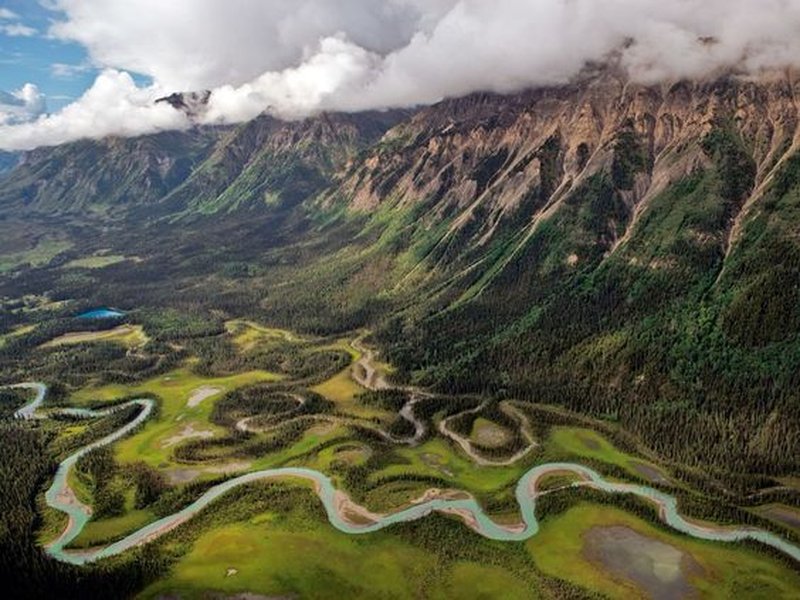
A river system showcasing meanders and an oxbow lake. Uplift can cause such systems to incise, preserving these features in the landscape.
Subsidence, the sinking of land, has the opposite effect. It reduces the river's gradient and energy, leading to:
- Aggradation: Rivers in subsiding areas tend to deposit sediment (aggrade) as their capacity to transport material decreases. This can result in wider floodplains and the accumulation of thick alluvial fills.
- Ponding and Marshes: Localized subsidence can create depressions where water accumulates, forming ponds, lakes, or marshlands along the river's course.
Faulting and Tilting: Disrupting the Flow
Faults are fractures in the Earth's crust where movement occurs. This movement can be vertical (dip-slip faults like normal and reverse/thrust faults) or horizontal (strike-slip faults).
- Channel Offset and Deflection: Strike-slip faulting can horizontally displace river channels, creating characteristic "dog-leg" bends or offsets. Vertical faulting can create fault scarps that rivers must flow over (forming waterfalls or rapids) or that block and deflect river courses.
- Asymmetric Valleys and Drainage Patterns: Tilting of land blocks due to fault movement can cause rivers to migrate towards the down-tilted side, leading to asymmetric valley cross-sections and skewed drainage patterns. The Transverse Topographic Symmetry Index (TTSI) is a tool used to identify such tilting.
- River Capture: Tectonic uplift or tilting can shift drainage divides, sometimes causing a river from one basin to "capture" the headwaters of another, rerouting its flow.
- Anomalous River Patterns: Sudden changes in channel pattern (e.g., from meandering to braided), unexplained widening or narrowing, or the appearance of anomalous curves can all indicate underlying fault control.
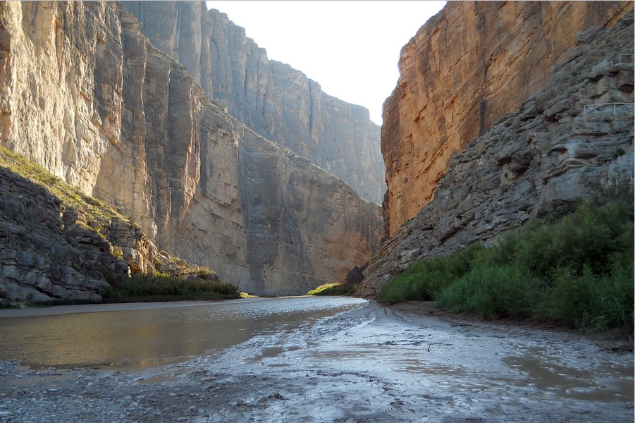
The Rio Grande in Big Bend National Park, a river system whose path and dramatic canyons are heavily influenced by regional tectonic history and uplift.
Sediment Dynamics: The Shifting Load
Tectonic activity profoundly influences the erosion rates in source areas and, consequently, the sediment supply to rivers. Uplifted areas are typically subject to accelerated erosion, leading to an increased sediment load in rivers. This can cause:
- Sediment Pulses: Bursts of tectonic activity can generate pulses of sediment that travel downstream, affecting channel morphology, floodplain development, and the formation of alluvial fans and deltas.
- Changes in Depositional Environments: Increased sediment supply can lead to aggradation in downstream reaches, while decreased supply (e.g., due to damming by fault scarps) can lead to channel incision further downstream.
Visualizing Tectonic-Fluvial Interactions: A Mindmap
The relationship between active tectonics and fluvial systems is a complex network of causes and effects. The mindmap below illustrates these key interactions, showing how different tectonic processes lead to various fluvial responses and geomorphic features. It highlights the interconnectedness of crustal movements and surface water dynamics.
This mindmap provides a structured overview, connecting specific tectonic actions like uplift or faulting to their direct consequences on river channels, drainage patterns, and sediment transport. Understanding these links is crucial for interpreting landscapes in tectonically active regions.
Relative Impact of Tectonic Processes on Fluvial Characteristics
Different tectonic processes exert varying degrees of influence on specific aspects of fluvial systems. The radar chart below offers a conceptual representation of the relative impact strength of key tectonic activities on several fluvial characteristics. The values are qualitative, based on generalized geomorphological understanding, illustrating dominant relationships rather than precise quantitative data. For visual clarity, the axis begins above zero, ensuring all data points are distinctly visible.
This chart illustrates, for example, that regional uplift strongly influences river incision, knickpoint formation, and terrace development. In contrast, strike-slip faulting has a more pronounced impact on channel pattern change and drainage network reorganization. Subsidence primarily drives floodplain aggradation and can increase sediment load variation due to reduced transport capacity.
Indicators of Active Tectonics in Fluvial Systems
Geomorphologists look for specific clues within a river system to infer underlying tectonic activity. The table below summarizes some key fluvial indicators and the tectonic processes they often signify.
| Fluvial Indicator | Potential Tectonic Process | Description |
|---|---|---|
| Knickpoints / Abrupt Slope Changes | Uplift, Faulting (across river path) | Steep segments in the river's longitudinal profile, often migrating upstream. |
| River Terraces (paired or unpaired) | Uplift, Base-level fall | Abandoned former floodplains at higher elevations than the current river. |
| Incised Meanders | Rapid Uplift (of a meandering river) | Deeply cut, winding river channels in bedrock. |
| Channel Offsets / Deflections | Strike-slip Faulting, Dip-slip Faulting | Sudden lateral shifts or sharp bends in the river course aligned with fault traces. |
| Asymmetric Valley Cross-sections | Tilting of land blocks | One side of the valley is significantly steeper or has different terrace development than the other. |
| Anomalous Channel Patterns (e.g., sudden braiding, narrowing) | Localized Uplift, Subsidence, Faulting | Changes in river form not explainable by local geology or climate alone. |
| Anomalous Ponds, Marshes, or Alluvial Fills | Subsidence, Fault-damming | Localized depressions or areas of thick sediment accumulation inconsistent with regional patterns. |
| Changes in Sediment Caliber or Load | Uplift (increased erosion), Subsidence (decreased transport) | Variations in the size or amount of sediment carried by the river. |
| Disrupted or Segmented Alluvial Fans | Faulting across the fan surface | Offsets or changes in slope on alluvial fan surfaces indicating recent movement. |
It is important to note that many fluvial features can have multiple origins (polygenetic), and careful analysis is required to distinguish tectonic influences from climatic or lithological controls.
Tectonic Geomorphology: A Deeper Dive
Understanding the intricate dance between Earth's internal forces and surface processes is the realm of tectonic geomorphology. Rivers, being highly sensitive to changes in slope and base level, act as excellent recorders of tectonic activity. The following video provides insights into some fundamental concepts of tectonic geomorphology, which underpins our understanding of how tectonics sculpts fluvial landscapes.
This lecture discusses aspects of tectonic geomorphology, relevant to understanding how Earth's crustal movements, like faulting, impact landforms including river systems.
The video touches upon how features like fault scarps are formed and recognized, which directly ties into how rivers might respond when encountering such tectonic structures. For instance, a river flowing across an active fault might be deflected, ponded, or forced to incise rapidly, creating distinctive fluvial anomalies that geologists use to map and understand recent tectonic movements.
Timescales and Buffering Effects
The response of fluvial systems to tectonic perturbations is not instantaneous. There are characteristic response times, which can vary from tens of thousands to millions of years (105 to 106 years). This depends on factors like the size of the drainage basin, the magnitude of the tectonic event, the underlying geology, and climatic conditions. Fluvial systems can act as "buffers" to tectonic signals, meaning the effects of an uplift event might take considerable time to propagate throughout the entire river network. For example, a knickpoint generated by uplift at a fault will gradually migrate upstream, and the landscape above it will only adjust as the knickpoint passes. Landscapes can be described as "reactive" if their response time is short relative to the repeat time of tectonic events, or "buffered" if it's long.
Tools for Deciphering Tectonic Signatures
Scientists employ a range of tools and techniques to study the influence of active tectonics on fluvial systems:
- Digital Elevation Models (DEMs): High-resolution DEMs are crucial for analyzing topography, extracting river profiles, and identifying geomorphic anomalies that may indicate tectonic activity.
- River Profile Analysis: Mathematical analysis of longitudinal river profiles, using tools like the stream power law, helps identify knickpoints and assess concavity and steepness indices, which can reflect tectonic uplift rates.
- Geomorphic Indices: Various indices, such as the Transverse Topographic Symmetry Index (TTSI), valley floor width to height ratio (Vf), and mountain front sinuosity (Smf), are used to quantify landscape features and infer tectonic controls.
- Field Mapping and Structural Analysis: Detailed geological mapping in the field helps identify faults, folds, and other structures and relate them to fluvial landforms.
- Sedimentology and Stratigraphy: Studying the characteristics and layering of river sediments (alluvium) can reveal past changes in depositional environments, often linked to tectonic events.
- Geochronology: Dating techniques (e.g., cosmogenic radionuclide dating, OSL dating) applied to river terraces, alluvial fans, or fault scarps help establish the timing and rates of tectonic movements and landscape evolution.
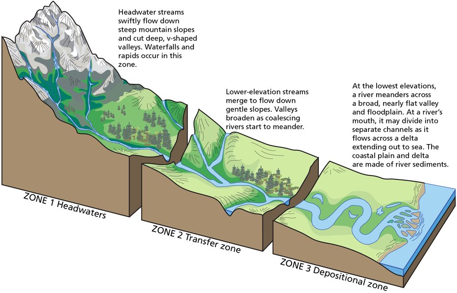
The three primary zones of a fluvial system – erosion (headwaters), transport, and deposition (mouth). Tectonic activity can influence processes within each of these zones.
Frequently Asked Questions (FAQ)
What is the primary effect of tectonic uplift on a river?
The primary effect of tectonic uplift on a river is an increase in its gradient (slope). This leads to increased stream power, causing the river to incise or cut down into its bed. This process can form features like river terraces, incised meanders, and knickpoints (abrupt changes in slope like waterfalls or rapids) that migrate upstream.
How can faulting change a river's course?
Faulting can change a river's course in several ways. Vertical movement along a fault can create a scarp (a steep slope or cliff) that blocks or diverts the river. Lateral movement (strike-slip faulting) can offset the river channel, creating sharp, angular bends. Tilting associated with faulting can also cause a river to migrate laterally across a floodplain.
What is a knickpoint and how does it relate to active tectonics?
A knickpoint is a sharp break in the longitudinal profile of a river, such as a waterfall or a stretch of rapids, where the gradient steepens abruptly. Knickpoints are often indicators of active tectonics, particularly uplift or a drop in base level caused by faulting. As the river erodes, these knickpoints typically migrate upstream, acting as a wave of incision adjusting the river profile to the new tectonic conditions.
Can active tectonics affect sediment deposition in rivers?
Yes, active tectonics significantly affects sediment deposition. Tectonic uplift in source areas can increase erosion rates, leading to a higher sediment load in rivers and increased deposition downstream (e.g., larger alluvial fans or deltas). Conversely, tectonic subsidence can create accommodation space, leading to the accumulation of thick layers of sediment (aggradation) and the widening of floodplains.
Recommended Further Exploration
- How do geologists differentiate between climatic and tectonic influences on river terraces?
- What are the specific fluvial responses to strike-slip faulting versus dip-slip faulting?
- Explain the concept of stream power and its relevance in analyzing tectonically active fluvial systems.
- What are some case studies of major rivers significantly shaped by active tectonics?
References

 assets.publishing.service.gov.uk
 aardlink.files.wordpress.com
Last updated May 13, 2025