
Unveiling the Realgrunnen Subgroup: A Geological Cornerstone of the Barents Sea
Exploring the Hydrocarbon Potential and Geological Significance of a Key Stratigraphic Unit
Key Highlights of the Realgrunnen Subgroup in the Barents Sea
- Primary Hydrocarbon Reservoir: The Realgrunnen Subgroup is recognized as the most prolific reservoir package in the southwestern Barents Sea, hosting significant hydrocarbon accumulations in major fields like Goliat, Snøhvit, and Johan Castberg.
- Diverse Depositional Environments: Deposited during the Late Triassic to Middle Jurassic, the Realgrunnen Subgroup reflects a variety of environments, from continental fluvial channels and coastal plains to shallow marine and deltaic settings, showcasing complex sedimentological controls.
- Crucial for Exploration: Despite extensive drilling (over 120 wells), the Realgrunnen Play remains the most significant play in the Norwegian Barents Sea, with ongoing exploration leveraging advanced seismic imaging technologies to identify new prospects.
The Barents Sea, a marginal sea of the Arctic Ocean, is a region of immense geological interest and significant hydrocarbon potential. Covering approximately 1,405,000 km2, it is characterized by a relatively shallow continental shelf and a complex geological history shaped by major continental collisions and extensional tectonics. Among its many stratigraphic units, the Realgrunnen Subgroup stands out as a critical component, primarily due to its role as a prolific hydrocarbon reservoir.
Geological Context of the Barents Sea
A Frontier Basin with Rich History
The Barents Sea's geological evolution is a story of dynamic tectonic activity. It was initially formed by the Caledonian orogeny, where the Baltica and Laurentia landmasses collided, followed by a subsequent collision between Laurasia and Western Siberia. These events set the stage for later extensional tectonics, leading to the formation of major rift basins, platforms, and structural highs that characterize the Barents Shelf today. The region's later geological history, particularly during the Late Cenozoic, is marked by significant uplift and erosion, largely influenced by Quaternary glaciation.
The Barents Sea is divided into several main structural elements, including the Hammerfest and Nordkapp Basins, the Finnmark and Bjarmeland Platforms, and the Loppa High. These features, along with smaller elements like the Polheim Sub-platform, Senja Ridge, Veslemøy, and Norsel High, collectively define the basin's architecture. The western and eastern parts of the southern Barents Sea exhibit distinct tectonic and stratigraphic developments, separated by major N-S to NNE-SSW trending fault complexes like the Ringvassøy-Loppa and Bjørnøyrenna Fault Complexes.
Hydrocarbon source rocks and reservoir rocks are found at various stratigraphic levels across the Barents Sea, ranging in age from Paleozoic to Paleogene. The Barents Sea is considered one of the last remaining frontier exploration areas on the Norwegian Continental Shelf (NCS), accounting for around half of the undiscovered resources on the NCS.
The Realgrunnen Subgroup: A Detailed Geological Overview
Defining Characteristics and Extent
The Realgrunnen Subgroup, sometimes referred to as the Realgrunnen Group, is a prominent lithostratigraphic unit within the Kapp Toscana Group. It was originally defined in the Hammerfest Basin but is now applied to all correlated deposits across the southern Barents Sea. This subgroup comprises sandstones and shales deposited during the Late Triassic to Middle Jurassic period, forming a crucial interval for hydrocarbon exploration.
The thickness of the Realgrunnen Subgroup typically varies between 100 and 200 meters, although its complete development is observed in the southwestern Barents Sea. Here, it consists of mature sandstones laid down in environments ranging from continental fluvial channels and coastal plains to shallow marine and deltaic settings. Key formations within the Realgrunnen Subgroup include the Tubåen, Nordmela, Stø, and Fruholmen Formations, as well as the Wilhelmøya Formation and its correlatives in the offshore Troms area.
Depositional Environments and Sedimentological Controls
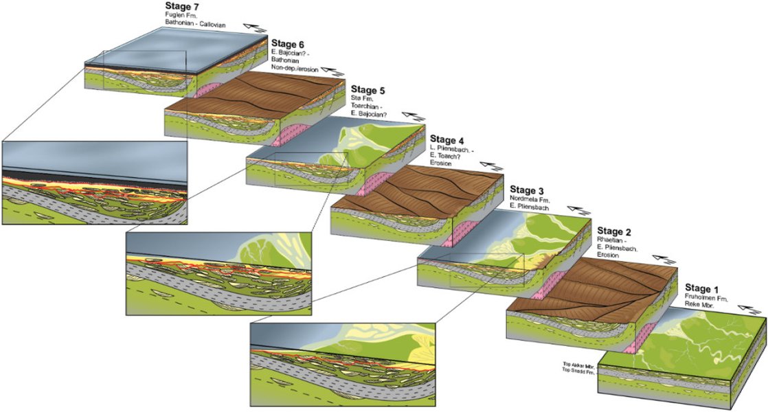
The depositional history of the Realgrunnen Subgroup is complex, reflecting a major shift in the basin's structural evolution. In the early Jurassic, coastal marine environments evolved, transitioning into a variety of shoreface, barrier, and tidal environments from the Toarcian to the Bajocian. The sediments are primarily characterized by shallow marine and coastal reworking of deltaic and fluviodeltaic deposits. Attribute mapping of 3D seismic data, particularly over structures like the Haapet Dome in the Barents Sea South, reveals intricate channel systems within the Realgrunnen Subgroup, indicating fluvial origins and a south-east to north-west flow direction.
The provenance of these sediments likely lies either on Novaya Zemlya or further south in the Ural mountain chain. This fluvial dominance was eventually interrupted by a regional marine transgression during the Norian stage, leading to the deposition of shale intervals, possibly equivalent to the Flatsalen Formation in Svalbard and the lower part of the Fruholmen Formation in the Barents Sea.
Here's a table summarizing the key aspects of the Realgrunnen Subgroup:
| Characteristic | Description |
|---|---|
| Age | Upper Triassic to Middle Jurassic |
| Composition | Predominantly mature sandstones, with interbedded shales and claystones |
| Thickness | Typically 100-200 meters, with localized greater development |
| Key Formations | Tubåen, Nordmela, Stø, Fruholmen, Wilhelmøya |
| Depositional Environments | Continental fluvial, coastal plain, deltaic, shallow marine, shoreface, barrier, tidal |
| Significance | Most prolific hydrocarbon reservoir in the SW Barents Sea |
Regional Mapping and Hydrocarbon Plays
Mapping the Realgrunnen for Exploration
Regional geological maps of the Barents Sea are crucial for understanding the distribution and potential of the Realgrunnen Subgroup. These maps integrate seismic data, well logs, and fieldwork from areas like Svalbard to establish a common stratigraphic framework. The purple color on some geological maps of the Barents Sea indicates sandstones from the Triassic period, which are part of or related to the Realgrunnen Subgroup, while younger Jurassic-Cretaceous blue areas indicate other formations.
The southwestern Barents Sea, with its complex geological regime and heterogeneous overburden, is a particularly active area for exploration. The Realgrunnen Subgroup represents a primary target, especially for its Early to Middle Jurassic sections, where seismic data often reveal "flat events" correlating with slow velocities, indicating potential hydrocarbon presence. These anomalies are identified through velocity attribute maps extracted at the Top Realgrunnen level.
The radar chart above illustrates a comparative assessment of the Realgrunnen Subgroup against other typical Barents Sea plays across several key dimensions. The Realgrunnen Subgroup scores highly in "Hydrocarbon Potential" and "Reservoir Quality" due to its established production in fields like Goliat and its well-characterized sandstone formations. Its "Exploration Maturity" is moderate, as extensive drilling has occurred, but new technologies are still revealing undiscovered resources. The "Geological Complexity" for the Realgrunnen is notable given its diverse depositional environments, and "Seismic Imaging Challenge" is present but often mitigated by advanced technologies. In contrast, "Other Barents Sea Plays" may represent deeper, more complex, or less explored targets, often presenting higher geological complexity and seismic imaging challenges, along with generally lower exploration maturity and, on average, lower current hydrocarbon potential and reservoir quality.
Seismic Imaging and Advanced Techniques
Modern seismic acquisition and processing technologies are critical for accurately imaging the Realgrunnen Subgroup. The Barents Sea presents unique challenges, including shallow water depths, a hard and rugose seafloor that generates noise, and a complex geological regime with heterogeneous overburden and mixed target depths. Technologies like GeoStreamer broadband data and complete wavefield imaging (CRW), which combine tomography, Full Waveform Inversion (FWI), and Separated Wavefield Imaging (SWIM), are employed to produce high-density, high-resolution datasets. These advanced methods help to resolve shallow layers and deeper targets, providing reliable data for amplitude analysis and identifying subtle structural closures and low-velocity anomalies indicative of hydrocarbons.
For instance, FWI velocity updates have proven effective around the Goliat field, capturing small-scale velocity anomalies associated with hydrocarbon accumulations at depths of around 2.5 km, particularly at the Top Realgrunnen level. This technological advancement is essential for derisking prospects in frontier areas where well control is sparse.
Significant Discoveries and Future Potential
The Realgrunnen's Role in Major Fields
The Realgrunnen Subgroup is the primary reservoir unit in several of the Barents Sea's most significant hydrocarbon accumulations, including the Goliat, Snøhvit, and Johan Castberg fields, and the Wisting discovery. The Goliat field, for example, is the first oil production infrastructure in the Barents Sea, and recent appraisal wells have confirmed additional hydrocarbon-bearing sandstones within the Realgrunnen Subgroup, further enhancing its profitability and strategic importance for regional development.
The image below provides a visual context for the geographical spread of these key fields and structures in the Barents Sea, emphasizing the areas where the Realgrunnen Subgroup plays a critical role.
Map illustrating key geological features and areas of interest in the Barents Sea, highlighting the widespread distribution of the Realgrunnen Subgroup.
Despite numerous wells drilled, the Realgrunnen Play continues to be a primary focus for exploration due to its consistent success and the remaining undiscovered potential. The ongoing efforts to map and characterize this subgroup are vital for unlocking future resources in this geologically complex and economically significant region.
Frequently Asked Questions (FAQ)
What is the Realgrunnen Subgroup?
Why is the Realgrunnen Subgroup important for hydrocarbon exploration?
Where is the Realgrunnen Subgroup most developed in the Barents Sea?
What challenges exist in exploring the Realgrunnen Subgroup?
What are the main formations within the Realgrunnen Subgroup?
Recommended Further Reading
- Explore the comprehensive geological history and tectonic evolution of the wider Barents Sea region.
- Investigate other significant hydrocarbon plays and discoveries across the Norwegian Continental Shelf.
- Learn about cutting-edge seismic imaging techniques used for exploration in challenging frontier basins.
- Delve deeper into how sedimentological processes influence reservoir quality in deltaic and fluvial systems.
References
Last updated May 21, 2025