
Unraveling the Mystery: Why Central India is Experiencing Unexpected May Showers
A deep dive into the meteorological phenomena behind the current unseasonal rainfall.
Central India is currently witnessing unusual rainfall for the month of May, a period typically characterized by rising temperatures and dry, pre-monsoon conditions. This deviation from the norm is attributed to a complex interplay of several meteorological factors. Understanding these elements provides clarity on why regions like Madhya Pradesh, Chhattisgarh, and parts of Maharashtra and Uttar Pradesh are experiencing these unseasonal showers.
Key Factors at Play: Highlights of the Current Weather Scenario
The primary drivers behind Central India's May rainfall.
- Active Western Disturbances: These extra-tropical storms, originating in the Mediterranean region, are currently influencing weather patterns by bringing significant moisture to the Indian subcontinent.
- Formation of Cyclonic Circulations and Troughs: Induced by Western Disturbances and other atmospheric conditions, these systems are drawing in moisture and triggering localized thunderstorms and rainfall.
- Increased Atmospheric Moisture & Shifting Patterns: A general rise in atmospheric moisture content, potentially exacerbated by broader climate variability and change, is creating conditions more conducive to precipitation.
The Driving Forces: A Closer Look at the Meteorological Causes
Understanding the science behind the unseasonal downpours.
The Potent Influence of Western Disturbances
A primary catalyst for the current rainfall is the activity of Western Disturbances. These are extra-tropical storm systems that originate over the Mediterranean Sea, Caspian Sea, and Black Sea. They travel eastward across the Middle East and enter the Indian subcontinent, primarily during the winter and pre-monsoon months. While they are crucial for rabi crop irrigation in Northern India during winter, their strong presence in May can lead to unseasonal rainfall in central parts of the country.
In May 2025, multiple Western Disturbances have been observed, leading to the formation of cyclonic circulations over regions such as central Pakistan and adjoining west Rajasthan. These disturbances inject substantial moisture into the lower and upper atmospheric layers, which then gets advected towards Central India, creating instability and fostering conditions for rainfall, thunderstorms, and sometimes hailstorms. For instance, similar patterns in previous years, like May 2023, saw Central India receiving significantly higher-than-normal rainfall (e.g., a reported 268% increase in the first three days of May in one instance) due to the influence of multiple Western Disturbances in preceding months.
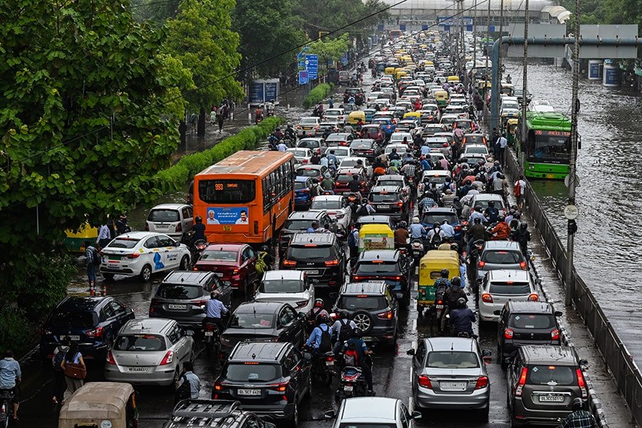
Unseasonal rains can disrupt daily life, as depicted here in a city scene.
Cyclonic Circulations and Troughs: Local Weather Instigators
The Western Disturbances often induce secondary weather systems, such as cyclonic circulations and troughs of low pressure. These systems play a vital role in enhancing and localizing rainfall. Currently, cyclonic circulations have been reported over areas like southwest Uttar Pradesh and south Chhattisgarh. Additionally, troughs—elongated areas of low atmospheric pressure—can extend from these circulations, acting as channels for moisture convergence.
These circulations and troughs effectively trap moisture drawn from the Arabian Sea and other nearby water bodies, leading to the development of convective clouds. This results in intense, often localized, downpours, thunderstorms accompanied by gusty winds (sometimes reaching 40-50 km/h), and occasionally hailstorms. The India Meteorological Department (IMD) bulletins frequently highlight these systems as key drivers of the observed rainfall in Central India.
Increased Atmospheric Moisture and the Climate Change Angle
There's a growing body of evidence suggesting that rising global temperatures are leading to increased moisture content in the atmosphere. A warmer atmosphere can hold more water vapor, which, when combined with suitable trigger mechanisms (like Western Disturbances or cyclonic circulations), can lead to more intense and sometimes erratic rainfall events.
Scientific studies, including research published in journals like Nature Communications, have pointed towards a significant rise (e.g., a threefold increase) in widespread extreme rain events over Central India. While not every unseasonal rain event can be directly attributed solely to climate change, the broader trend of erratic weather, increasing instances of extreme precipitation, and shifts in monsoon dynamics are consistent with climate change impacts. Phenomena like El Niño, which affects global weather patterns, can also indirectly contribute to unusual precipitation patterns in various parts of the world, including India, by altering atmospheric circulation.
Seasonal Transition and Pre-Monsoon Activity
May is a transitional month in India, marking the period between the hot summer season and the onset of the southwest monsoon, which typically begins in June. Pre-monsoon showers are a characteristic feature of this period, especially in southern and eastern parts of India. However, the current rainfall in Central India appears to be more intense and widespread than typical pre-monsoon activity for this specific region and time. While some rainfall is expected, the current patterns, driven by the strong influence of the aforementioned systems, are leading to what many perceive as "unseasonal" rain due to its intensity and geographical spread across Central India.
Visualizing the Contributing Factors
Relative Impact of Meteorological Elements on Central India's May Rainfall
The following chart provides an illustrative representation of the perceived relative influence of different meteorological factors contributing to the current unseasonal rainfall in Central India. The scores are conceptual and aim to highlight the significance of each factor based on current understanding and reports.
This chart illustrates that active Western Disturbances and resultant cyclonic circulations are currently the most direct and significant drivers. Elevated atmospheric moisture and potential amplification due to climate change create a conducive background, while typical pre-monsoon mechanisms also contribute, albeit perhaps overshadowed by the more dominant systems this year.
Understanding Western Disturbances: A Key Driver
Learn more about these influential weather systems.
Western Disturbances are crucial to India's weather, especially in the northern and northwestern regions during winter. However, their influence can extend to central India and persist into the pre-monsoon season, as is being observed now. The video below provides a good overview of what Western Disturbances are and how they impact weather conditions in the Indian subcontinent.
These systems gather moisture from the Mediterranean Sea and surrounding areas. As they move eastward, they interact with the Himalayan topography and the existing atmospheric conditions over the Indian plains. This interaction can lead to cloud formation, precipitation (rain or snow at higher altitudes), and changes in temperature. Their current activity level and southward track are key reasons for the May rains in Central India.
Mapping the Interconnected Causes
A mindmap illustrating the network of factors leading to Central India's May rainfall.
The unseasonal rainfall in Central India is not due to a single isolated cause but rather a convergence of multiple atmospheric phenomena. This mindmap visualizes the primary drivers and their interconnections, offering a clearer picture of this complex weather event.
This mindmap highlights how Western Disturbances act as a primary trigger, leading to cyclonic circulations and troughs. These are amplified by increased atmospheric moisture, potentially linked to climate change, all occurring within the broader context of the pre-monsoon transition. The consequences affect various sectors, from agriculture to the general economy.
Impacts of Unseasonal May Rainfall
Effects on agriculture, economy, and daily life.
While rain is often welcomed, especially in regions prone to water scarcity, unseasonal rainfall of this nature in May can have several adverse consequences. The timing and intensity are crucial factors.
| Aspect | Typical May Conditions in Central India | Current Unseasonal Rain Scenario | Potential Impacts |
|---|---|---|---|
| Temperature | Generally hot and dry, rising temperatures. | Cooler than normal due to cloud cover and rain. | Temporary relief from heat, but can affect crop maturation. |
| Precipitation | Scattered, light pre-monsoon showers, if any. | Widespread, moderate to heavy rainfall, thunderstorms. | Waterlogging, flash floods in vulnerable areas. |
| Agriculture | Land preparation for Kharif crops, harvesting of some late Rabi crops or summer crops. | Damage to standing crops (e.g., wheat, pulses, fruits) nearing harvest or already harvested and drying. Delay in land preparation. | Yield losses, economic hardship for farmers, potential impact on food supply and prices. |
| Construction Industry | Peak construction activity due to dry weather. | Work disruptions, potential increase in raw material costs (steel, cement) due to logistical issues. | Project delays, increased costs. |
| Consumer Behavior | Increased demand for cooling appliances, summer wear. | Potential decrease in demand for non-essential goods and outdoor activities. | Shift in spending patterns. |
| Monsoon Outlook | Anticipation and forecasts for the upcoming Southwest Monsoon. | Raises questions about its impact on the onset and distribution of the main monsoon. Complex relationship - could be disruptive or sometimes linked to early moisture build-up. | Uncertainty for agricultural planning for the main monsoon season. |
The agricultural sector is particularly vulnerable. Crops that are mature and ready for harvest, or those already harvested and left in fields to dry, can be severely damaged by unexpected heavy rains and hailstorms. This can lead to significant economic losses for farmers and potentially contribute to food price inflation. Furthermore, such weather can disrupt the construction industry and influence general consumer spending habits.
Frequently Asked Questions (FAQ)
Is this type of rain normal for Central India in May?
While May is a pre-monsoon month and some thunderstorm activity can occur, the current intensity, widespread nature, and persistence of rainfall in Central India are generally considered unusual or "unseasonal." Typically, May is characterized by hot and dry weather, with more sporadic and localized pre-monsoon showers, particularly in southern and eastern India rather than extensive spells over Central India.
How long is this unseasonal rain expected to last?
The duration of such rainfall events depends on the persistence of the meteorological systems causing them, such as Western Disturbances and associated cyclonic circulations. Weather forecasts from the India Meteorological Department (IMD) provide updates on their expected movement and weakening. Typically, such systems may influence the weather for several days to a week.
Does this unseasonal rain affect the upcoming monsoon?
The relationship between pre-monsoon unseasonal rains and the subsequent Southwest Monsoon is complex and not always direct. Heavy pre-monsoon rains can sometimes alter local atmospheric conditions (e.g., soil moisture, temperature gradients), but the larger-scale monsoon is driven by broader global and regional climatic factors. Some experts suggest that very active pre-monsoon weather could sometimes be linked to changes in monsoon dynamics, but specific impacts vary year by year.
What precautions should be taken during such weather?
During thunderstorms and heavy rain, it's advisable to stay indoors and avoid areas prone to waterlogging. Ensure drains around your house are clear. Farmers should try to protect harvested crops and take measures to drain excess water from fields if possible. Stay updated with official weather advisories from the IMD.
Recommended Further Exploration
Delve deeper into related weather phenomena and their impacts.
- How do Western Disturbances form and affect India's weather patterns throughout the year?
- What is the long-term trend of extreme rainfall events in Central India and its connection to climate change?
- Explain the typical pre-monsoon weather characteristics across different regions of India.
- What are the economic consequences of unseasonal rainfall on Indian agriculture and other sectors?
References
Sources used for this analysis.
Last updated May 6, 2025