
Unlock Centimeter Precision: A Deep Dive into the Real-Time Kinematic (RTK) System
Discover how RTK technology transforms standard satellite positioning into an ultra-precise tool for countless industries.
Highlights: Understanding RTK Fundamentals
- Centimeter-Level Accuracy: RTK elevates standard GNSS positioning from meter-level errors down to remarkable 1-2 centimeter precision.
- Base + Rover Synergy: The system operates using a stationary base station at a known point and a mobile rover, which communicate in real-time.
- Real-Time Corrections: The base station identifies positioning errors and transmits correction data instantly, allowing the rover to calculate its highly accurate location on the fly.
What is the RTK System?
Defining Precision Positioning
Real-Time Kinematic (RTK) positioning is an advanced satellite navigation technique used to significantly enhance the precision of location data obtained from Global Navigation Satellite Systems (GNSS), such as GPS, GLONASS, Galileo, and BeiDou. While standard GNSS receivers (like those found in smartphones or cars) typically offer accuracy within a few meters (2-4 meters), RTK refines this to achieve centimeter-level accuracy. It's not an entirely new satellite system but rather a sophisticated method or protocol that leverages existing GNSS infrastructure in a novel way to overcome common positioning errors.
Beyond Code: The Role of Carrier Phase
Standard GNSS receivers primarily determine position by measuring the time it takes for coded signals to travel from satellites to the receiver. However, these signals are susceptible to various interferences. RTK achieves its remarkable accuracy by utilizing an additional piece of information embedded within the satellite signal: the phase of the signal's carrier wave. The carrier wave has a much shorter wavelength than the coded signals, allowing for far more precise distance measurements between the satellite and the receiver once certain ambiguities are resolved.
How the RTK System Operates
The Dynamic Duo: Base Station and Rover
The core of an RTK system consists of two specialized GNSS receivers:
- The Base Station: This is a stationary GNSS receiver placed at a precisely surveyed and known location (often a benchmark point). Its primary job is to continuously monitor satellite signals, compare the calculated position from these signals with its known fixed position, and identify discrepancies or errors in real-time.
- The Rover: This is the mobile GNSS receiver that moves around the area where precise positioning is required. It could be mounted on survey equipment, a tractor, a drone, or any other platform needing accurate location data. The rover receives signals from the same satellites as the base station.
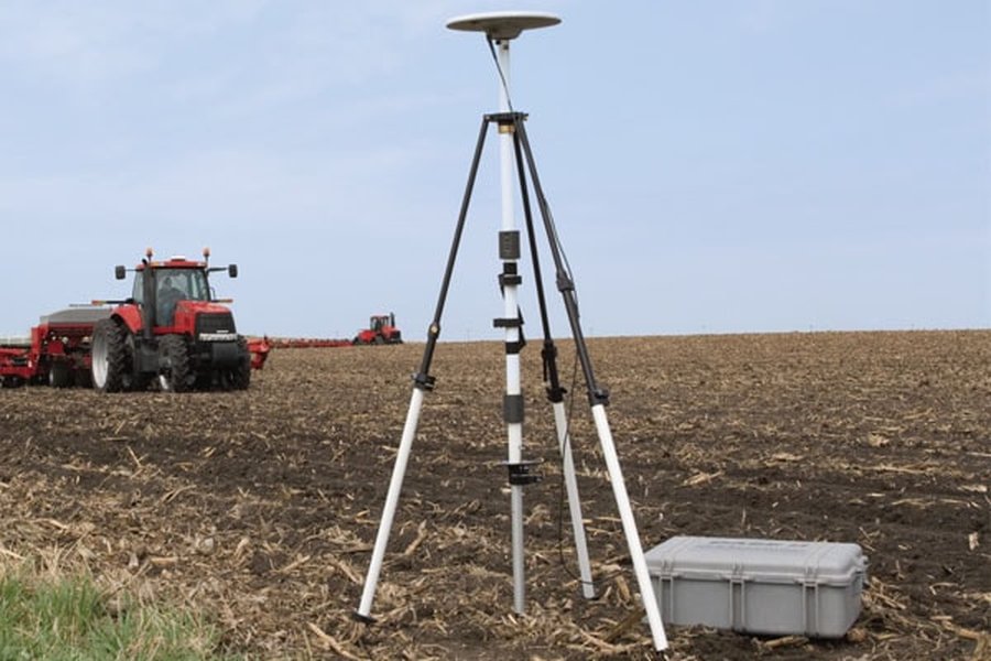
An example of an agricultural RTK Base Station.

A surveyor utilizing an RTK rover for precise measurements.
The Correction Workflow
The process enabling centimeter accuracy unfolds in several steps:
- Simultaneous Signal Reception: Both the base station and the rover(s) track signals from the same set of GNSS satellites simultaneously.
- Error Calculation at the Base: Because the base station knows its exact location, it can calculate the errors present in the satellite signals. These errors stem from various sources, including atmospheric delays (ionosphere and troposphere slowing down signals), satellite clock inaccuracies, and slight variations in satellite orbits (ephemeris errors).
- Transmission of Correction Data: The base station computes correction messages based on the detected errors. This correction data is then broadcast in real-time to any rovers operating within its range using a communication link. Standard formats like RTCM (Radio Technical Commission for Maritime Services) are often used for these messages.
- Rover Processing and Position Refinement: The rover receives the correction data from the base station. It then applies these corrections to its own satellite phase measurements. By incorporating the base station's error information, the rover can effectively eliminate most common GNSS errors and calculate its position relative to the base station with centimeter-level accuracy.
Bridging the Distance: Communication Links
A reliable, real-time data link between the base station and the rover is crucial for RTK operation. Common methods include:
- Radio Modems: Often using UHF frequencies, providing a direct link effective over shorter distances (up to 10-20 km typically). Specific frequencies may be allocated locally for RTK use.
- Cellular Networks: Using mobile internet (3G, 4G, 5G) to transmit corrections, often via NTRIP (Networked Transport of RTCM via Internet Protocol). This allows for potentially longer ranges if network coverage is available and can leverage networks of reference stations (CORS).
- Internet/Wi-Fi: Corrections can also be streamed over the internet from the base or a correction service provider, especially using NTRIP protocols.
The Secret Sauce: Integer Ambiguity Resolution
A key, and complex, part of the RTK process is "integer ambiguity resolution." When the rover first starts receiving signals, it knows the phase of the carrier wave it receives, but not the exact number of full wavelengths that traveled between the satellite and the receiver antenna. Resolving this "integer ambiguity" – determining the precise whole number of cycles – is computationally intensive but critical. Once the system achieves a "fixed solution" (meaning the integer ambiguities are resolved), it can attain the highest level of centimeter accuracy. Multi-frequency receivers generally achieve this fix faster and more reliably than single-frequency ones.
Visualizing RTK Components and Workflow
This mindmap illustrates the core components and relationships within an RTK system, showing how the base station, rover, satellites, and correction data interact to achieve high-precision positioning for various applications.
(GPS, GLONASS, Galileo, BeiDou)"] id2b["Carrier Phase Measurement"] id2b1["Integer Ambiguity Resolution"] id2c["Differential Correction"] id3["Data Communication"] id3a["Radio Link (UHF)"] id3b["Cellular Network (NTRIP)"] id3c["Internet (NTRIP)"] id3d["Correction Formats (e.g., RTCM)"] id4["Key Characteristics"] id4a["Centimeter-Level Accuracy"] id4b["Real-Time Operation"] id4c["Range Limitations (Base-Rover)"] id4d["Requires Clear Sky View"] id5["Primary Applications"] id5a["Surveying & Mapping"] id5b["Precision Agriculture"] id5c["Construction & Machine Control"] id5d["Drones (UAVs)"] id5e["Autonomous Vehicles"] id5f["Robotics"]
Achieving Centimeter Precision: Accuracy and Factors
The Accuracy Benchmark
When operating correctly with a fixed integer ambiguity solution, RTK systems typically achieve horizontal accuracy in the range of 1 to 2 centimeters and vertical accuracy of 2 to 5 centimeters. This represents a dramatic improvement over standalone GNSS, making RTK suitable for tasks demanding survey-grade precision.
Distance Matters: The Baseline Limit
The accuracy of RTK is highly dependent on the distance between the base station and the rover, known as the baseline. While some systems can operate with baselines up to 20 kilometers or more (especially using network RTK), accuracy generally degrades as the distance increases. This is because the atmospheric conditions experienced by the signals reaching the base and rover become less correlated over longer distances. For optimal performance and the highest accuracy (e.g., around 1.4 cm horizontally), maintaining a baseline within 10 kilometers is often recommended.
Environmental Considerations
RTK performance relies heavily on a clear, unobstructed view of the sky for both the base and the rover to track a sufficient number of satellites. Performance can be significantly degraded or impossible in environments with:
- Signal Blockage: Dense urban canyons with tall buildings, heavy tree canopy, tunnels, or under bridges can block satellite signals.
- Multipath Interference: Signals bouncing off nearby reflective surfaces (buildings, water, large vehicles) before reaching the receiver antenna can introduce errors that are difficult for RTK to fully mitigate.
Comparing RTK Factors: A Visual Analysis
This radar chart provides a comparative overview of RTK positioning against standard GNSS across several key factors. It highlights the trade-offs involved, showcasing RTK's superior accuracy potential but also its higher complexity and sensitivity to obstructions compared to standard GNSS methods. Scores are relative, illustrating general characteristics rather than exact measurements (higher score = generally better or higher).
Essential RTK Components: Hardware and Software
Implementing an effective RTK system requires specific hardware and software components working in concert. The following table outlines the key elements:
| Component Type | Item | Description/Importance |
|---|---|---|
| Hardware | RTK-Capable GNSS Receivers | Essential for both base and rover. Must be able to process carrier phase data and apply corrections. Multi-frequency (L1/L2/L5) and multi-constellation (GPS, GLONASS, Galileo, BeiDou) support is highly recommended for faster initialization, better reliability, and performance in challenging conditions. |
| Hardware | High-Quality GNSS Antennas | Crucial for receiving clean satellite signals and minimizing multipath errors. Antenna placement is also critical (stable for base, clear sky view for both). |
| Hardware | Base Station Setup | Includes the GNSS receiver and antenna mounted securely at a known point, a stable power supply, and a communication device (radio modem or internet connection) to transmit corrections. |
| Hardware | Rover Unit | Includes the GNSS receiver and antenna, often integrated into a portable pole, vehicle, drone, or handheld device, along with a communication device to receive corrections and usually a controller/display for operation. |
| Hardware | Communication Link | Radio modems, cellular modems (for NTRIP), or Wi-Fi/internet hardware to facilitate the real-time transfer of correction data from base to rover. |
| Software | RTK Processing Engine | Firmware or software (often embedded in the receiver or running on a controller) that performs the complex calculations, including signal tracking, error modeling, and integer ambiguity resolution. |
| Software | Correction Data Protocol | Software/firmware support for standard correction formats like RTCM, CMR, etc., ensuring interoperability between different manufacturers' equipment. NTRIP client software is needed for internet/cellular corrections. |
| Software | Field/Control Software | Applications run on data collectors or mobile devices that allow users to configure the system, monitor status (e.g., Fix/Float solution), collect measurements, stake out points, and manage survey jobs. Examples include Emlid Flow, SurvX, FieldGenius. |
| Software | Post-Processing Software (Optional) | While RTK is real-time, software like GIS or specialized survey software can be used for data management, analysis, quality control, and integration with other project data. |
RTK in Action: Diverse Applications
The ability to determine precise location in real-time has made RTK technology indispensable across a wide array of industries and applications:
- Surveying and Geomatics: Cadastral (boundary) surveys, topographic mapping, construction stakeout, monitoring deformation.
- Construction: Site layout, grading control for heavy machinery (bulldozers, excavators), pile positioning, as-built surveys.
- Precision Agriculture: Auto-steering (guidance) systems for tractors and combines, precise planting and seeding, variable rate application of fertilizers/pesticides, yield mapping, drone-based crop monitoring.
- Unmanned Aerial Vehicles (UAVs / Drones): Accurate navigation, georeferenced aerial mapping and photogrammetry without numerous ground control points (GCPs), infrastructure inspection.
- Autonomous Systems: Precise positioning for self-driving cars, delivery robots, and autonomous marine vessels.
- Machine Control: Guiding various types of machinery in mining, landfill operations, and infrastructure projects.
- Hydrography: Precise positioning for vessels conducting bathymetric surveys (seabed mapping).
- Robotics: Outdoor navigation for robots requiring exact location awareness.
- Scientific Research: Monitoring tectonic plate movement, glacier dynamics, environmental changes.
RTK technology integrated into agricultural equipment for precision farming.
Diving Deeper: Understanding RTK Implementation
For a visual and auditory explanation of how RTK works, including the roles of the base station, rover, and satellites in achieving centimeter accuracy, the following video provides a helpful overview. It covers the fundamental concepts discussed above, illustrating the flow of information and the principles behind the error correction process.
Frequently Asked Questions (FAQ)
What's the main difference between RTK and standard GPS/GNSS?
The primary difference lies in accuracy and methodology. Standard GNSS provides meter-level accuracy (typically 2-4 meters) by calculating position based on signal timing. RTK achieves centimeter-level accuracy (1-2 cm) by using a base station to calculate real-time errors in GNSS signals (including atmospheric delays) and transmitting these corrections to a rover, which then refines its position using carrier phase measurements.
How far can the rover be from the base station?
The distance, or baseline, affects accuracy. While communication links might reach further, optimal RTK accuracy is typically achieved within 10-20 kilometers (about 6-12 miles) from the base station. Beyond this range, atmospheric differences between the base and rover increase, reducing the effectiveness of the corrections and thus degrading accuracy.
Can RTK work anywhere?
No, RTK performance depends on several factors. Both the base and rover need a clear view of the sky to track a sufficient number of satellites (usually at least 5-6 common satellites). Performance suffers significantly in areas with signal obstructions like dense forests, urban canyons (between tall buildings), tunnels, or under bridges. A reliable communication link between the base and rover is also essential.
Is RTK expensive?
RTK systems are generally more expensive than standard GNSS receivers due to the specialized hardware (receivers capable of phase measurement, antennas, communication modules) and software required. However, costs have decreased significantly over the years, and for applications requiring high precision, the value derived from accuracy and efficiency often justifies the investment. Subscription costs may also apply if using network RTK correction services.
What does 'fixing integer ambiguity' mean?
This refers to the process where the RTK receiver determines the exact whole number of carrier signal wavelengths between each satellite and the receiver's antenna. Initially, the receiver measures the fractional part of the wavelength (the phase) but doesn't know the whole number count. 'Fixing' this ambiguity is a complex calculation vital for achieving the highest centimeter-level accuracy. A 'Float' solution means the ambiguity isn't fully resolved, resulting in lower (decimeter-level) accuracy, while a 'Fixed' solution indicates successful resolution and highest precision.
Recommended Further Exploration
- How does NTRIP work for RTK corrections?
- Compare RTK vs PPK (Post-Processed Kinematic) techniques.
- What are the best multi-band RTK receivers available today?
- Explore advancements in RTK for urban environments.
References
Last updated April 30, 2025