
Geological Mapping of the Eel River Deposits: A Deep Dive into Dynamic Landscapes
Unraveling intricate sedimentary processes and geological formations
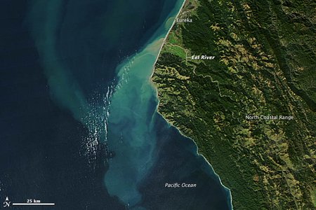
Key Highlights
- High Sediment Yield: The Eel River is one of the world’s most sediment-laden rivers, with a unique geological framework influenced by complex tectonics and sedimentary dynamics.
- Advanced Mapping Techniques: Modern approaches employ multibeam echosounders, remote sensing, and field mapping to characterize sediment distribution and structural features.
- Implications for Ecology and Resource Management: Detailed geological mapping supports hazard assessment, groundwater research, and resource exploration.
Overview of Geological Context
Geological mapping of the Eel River deposits is a multi-faceted endeavor that integrates data from field investigations, remote sensing techniques, and modern analytical methods. This mapping effort aims to delineate the composition, structure, and sedimentary history of the Eel River Basin, located primarily in Humboldt County, California. The region’s complex geology is largely governed by tectonic forces, sedimentation processes, and a dynamic interplay between marine and terrestrial environments.
The underlying bedrock is predominantly part of the Franciscan Assemblage, a sedimentary and metamorphic collection of rocks that dates back to the Late Jurassic period. Over time, marine transgressions, tectonic uplift, and erosional processes have contributed to the diversification of sediments and the formation of numerous depositional environments. The Eel River is recognized for having one of the highest sediment loads per unit area in the world, with suspended sediment and sand being significant contributors to its transport capacity.
Geological Formations and Structural Features
Primary Geological Units
The region is characterized by several distinct geological units, each representing different periods of deposition and structural evolution. The main formations from both pre-Tertiary and Cenozoic times have been mapped in detail. Among these:
- Franciscan Assemblage: The predominant sedimentary complex, offering a record of subduction-related processes and marine deposition.
- Wildcat Group Formations: This group includes formations such as the Pullen Formation, Eel River Formation, Rio Dell Formation, Scotia Bluffs Sandstone, and Carlotta Formation, which collectively record a transition from deep-water to shallower marine and alluvial environments.
Structural Dynamics
Structural features identified through geological mapping include significant synclines, anticlines, and fault systems. In particular:
- Major Eel River Syncline: A dominant fold that guides the structural pattern of the basin.
- Little Salmon Fault: A significant fault that influences sub-surface structures and sediment dispersal.
- Additional Anticlines: Smaller folded structures that indicate localized compressional forces acting within the basin.
These structures not only control sediment distribution but also have major implications for groundwater flow and geohazard potential, including landslides and seismicity.
Methodologies in Geological Mapping
Field Surveys and Remote Sensing
Comprehensive geological mapping combines traditional field surveys with advanced remote sensing technologies. Field geologists carry out detailed mapping and sample collection to confirm rock types and depositional characteristics. Simultaneously, aerial photography, satellite imagery, and LIDAR data are used to detect surface features and subtle variations in the topography that are indicative of sediment layers and fault lines.
These combined efforts have assisted scientists in identifying variations in deposit thickness, recognizing different sedimentary units (alluvial, colluvial, and glacial deposits), and mapping the extensive sediment dispersal across both the continental margin and adjacent offshore regions.
Advanced Mapping Technologies
Modern surveys incorporate multibeam echosounder (MBES) systems to generate high-resolution maps of the riverbed. These systems provide precise measurements of underwater topography and sediment characteristics, which are critical for understanding hidden geological features. Video-supervised and unsupervised classification techniques further refine these observations by categorizing substrates and outlining geomorphic patterns.
These technological advancements complement hydrogeologic mapping initiatives which examine groundwater resources in the Eel River Valley. Mapping efforts of the hydrogeologic framework help in understanding water-bearing formations like alluvial deposits and other Quaternary sediments that influence groundwater flow and storage.
Sedimentary Processes and Deposition
Sediment Sources and Distribution
The high sediment yield of the Eel River is a result of both natural and climatic factors. The region’s unstable geology, influenced by tectonic activity and weathering processes, produces large quantities of sediment. Approximately 25% of this sediment comprises sand, while fine-grained materials such as silt and clay are also prominent. This sediment is transported over long distances and deposited both in the river's estuary and on the adjacent continental shelf.
In many instances, the mapping has revealed that nearly half of the fine-grained sediment discharged into the river’s estuary is subsequently stored on the continental shelf. Such observations underscore the role of the river as a significant sediment conveyor on a global scale.
Depositional Environments
The sedimentary record of the Eel River Basin is complex due to its dynamic depositional environments. Early in its history, deep-water deposition prevailed, which later transitioned to shallower marine settings as a result of sea-level regression. Fluvial processes then dominated, leading to the deposition of alluvial and colluvial sediments. Key depositional environments include:
- Deep-Water Marine Environments: Characterized by finer sediment deposition at great depths during periods of high sea levels.
- Shallow Marine Settings: Marked by a gradual transition from deep-water sedimentation to coastal deposition, influenced by tectonic uplift.
- Fluvial and Alluvial Deposits: Resulting from river dynamics and sediment transport, often forming terraces along the Eel River’s course.
Geological Structures and Their Implications
Structural Interpretation
The geological mapping of the Eel River Basin not only aids in reconstructing past environmental conditions but also plays a crucial role in modern hazard assessment and resource management. The mapped features, including synclines, anticlines, and fault zones, inform predictive models for sediment stability and potential landslide occurrences. For example, the interplay between tectonic uplift and rapid sedimentation contributes to the formation of stream terraces and influences river channel stability.
This synthesis of structural and sedimentological data is invaluable for understanding potential natural hazards such as earthquakes and landslides, especially in regions where human settlements and infrastructural developments are at risk.
Hydrogeologic Considerations
A significant aspect of Eel River mapping involves delineating groundwater basins and identifying water-bearing formations. Sedimentary processes have resulted in the accumulation of alluvial deposits that serve as key aquifers, influencing local water management practices. Mapping efforts that integrate geological and hydrogeologic data reveal the distribution of groundwater resources and support efforts aimed at sustainable water use. These mappings are essential for predicting how sediment deposition may affect aquifer recharge and water quality over time.
Comparative Analysis of Geological Mapping Techniques
Summary Table of Key Geological Information
| Feature | Description | Implications |
|---|---|---|
| Franciscan Assemblage | Ancient sedimentary and metamorphic rock suite from the Late Jurassic; foundational geology of the basin. | Controls the underlying geologic framework and influences sediment composition and stability. |
| Wildcat Group Formations | Includes formations such as the Pullen, Eel River, Rio Dell, Scotia Bluffs Sandstone, and Carlotta. | Records transition from deep-water to shallow, providing insights into historical depositional environments. |
| Structural Features | Major synclines, anticlines, and fault lines including the Little Salmon Fault. | Inform hazard assessments and guide groundwater and sediment transport models. |
| Mapping Technologies | Integration of field surveys, remote sensing (LIDAR, aerial imagery), and MBES systems. | Enhances resolution and accuracy of sediment distribution and geomorphic mapping. |
| Hydrogeologic Framework | Analysis of alluvial deposits, fractured formations, and water-bearing sediments. | Critical for sustainable water resource management and evaluating aquifer stability. |
In-Depth Case Studies and Observations
Eel River’s Sediment Load
The Eel River carries one of the highest sediment loads, contributing to both onshore and offshore sediment deposition. Studies reveal that approximately 25% of its transported material is sand, with significant amounts of fine-grained sediments subsequently deposited along the continental margin. The high sediment yield is a product of the basin’s unstable geology combined with intense weather events, particularly those driven by Pacific storm systems.
Observations indicate that nearly half of the fine sediments settle on the continental shelf, a process that informs broader discussions on sediment budgets and source-to-sink dynamics in modern geological studies.
Temporal Insights From Geological Mapping
Geological mapping efforts have also yielded essential temporal insights. For instance, the occurrence of a massive landslide approximately 22,000 years ago near Alderpoint led to a natural damming event that produced a long-lasting lake stretching over 30 miles. Such historical geological events are meticulously documented through a combination of stratigraphic studies, sediment analysis, and advanced mapping techniques, allowing researchers to reconstruct the basin's dynamic history with high fidelity.
By understanding the timing and sequence of depositional and tectonic events, scientists are better equipped to predict future sedimentary developments as well as assess ongoing geohazard scenarios in this seismically active region.
Resource Management and Environmental Implications
Groundwater Resources and Aquifer Mapping
The mapping of alluvial and fluvial deposits not only supports geological research but also plays a vital role in resource management. Detailed geological maps delineate the extents of aquifers and water-bearing formations, supporting local water management strategies. These efforts are crucial for mitigating risks associated with water scarcity or contamination, particularly in regions affected by high sediment yield and rapid geologic change.
The integration of geological and hydrogeologic mapping ensures that stakeholders are well informed about the spatial distribution and quality of groundwater resources, ultimately aiding in the sustainable management of this critical commodity.
Implications for Hazard Assessment
Given the dynamic nature of the Eel River Basin, understanding its geological mapping is indispensable for hazard assessment. The presence of fault lines, high sedimentation rates, and recorded historical landslide events contribute to the overall risk profile of the region. Mapping these features assists local authorities and planners in developing more robust mitigation strategies and land-use policies, thereby protecting both human communities and natural ecosystems.
References
- Hydrogeologic Framework Data - USGS
- CMECS Offshore Eel River - USGS Marine
- Eel River (California) - Wikipedia
-
Sediment Budgets in Eel River - ScienceDirect
-
USGS Publication OFR73236
Recommended Further Exploration
Last updated March 25, 2025