
Unveiling the Dynamics of Floodplains: Nature's Fertile and Formidable Landscapes
A Comprehensive Exploration of Formation, Ecology, and Human Interaction
Key Insights into Floodplains
- Formation by Dynamic River Processes: Floodplains are sculpted by the relentless interplay of a river's erosional power and its depositional activities, primarily through lateral migration and overbank flooding.
- Ecological Hotbeds and Natural Buffers: These unique landforms are vital ecosystems, supporting rich biodiversity and offering crucial services like floodwater storage, groundwater recharge, and natural filtration, which directly benefit both human and environmental well-being.
- Human Interaction and Management Imperatives: Despite their inherent benefits, floodplains are often sites of intense human activity, leading to challenges like habitat fragmentation and increased flood risk, underscoring the critical need for sustainable management practices.
A floodplain is a generally flat expanse of land adjacent to a river or stream, extending from its banks to the surrounding valley edges. This distinctive geographical feature is a product of ongoing river processes and is periodically inundated during periods of high water discharge. Far from being mere stretches of flat ground, floodplains are dynamic landscapes, rich in ecological diversity and offering invaluable ecosystem services that profoundly impact both natural environments and human societies.
The Genesis of a Floodplain: A Tale of Water and Earth
The Dual Forces of Erosion and Deposition
The formation of floodplains is a fascinating and intricate geological process, primarily driven by two major mechanisms: erosion and aggradation (or deposition). These processes work in concert, shaping the land over vast spans of time.
Erosion: Sculpting the Landscape
Erosion involves the wearing away of ground or soil by the continuous movement of water. As a river flows, especially in its middle and lower courses, it meanders—forming wide, curving bends. The force of the water on the outer bend of a meander causes erosion, cutting away at the bank and widening the valley floor. This lateral erosion is a key factor in creating the broad, flat areas characteristic of floodplains. Over time, any interlocking spurs that might initially restrict the river's path are removed, further contributing to the expansive, flat landscape.
Deposition: Building Up the Plain
Concurrently with erosion, the process of deposition plays an equally vital role. As a river overflows its banks during a flood event, its velocity decreases significantly, causing it to lose energy and drop the sediment it has been carrying. This sediment, often referred to as alluvium (composed of clays, silts, sands, and gravels), is deposited across the flooded area. This buildup of earthen material, known as aggradation or alluviation, gradually increases the height of the floodplain. The heaviest sediments, like sand, are often deposited near the river banks, forming natural levees, while finer silts and clays are carried further afield, creating fertile floodplain muds. The repeated cycle of flooding and deposition is what builds up the characteristic flat surface of a floodplain.

A meandering river within its broad floodplain, showcasing the results of lateral erosion and sediment deposition.
Channel Migration and Features
The lateral migration of river channels is fundamental to floodplain development. As meander curves enlarge, the alluvial material is constantly reworked, and the floodplain widens. The floodplain surface itself can bear numerous topographic features resulting from this dynamic channel movement. These include:
- Meander Scrolls: Linear or sinuous ridges and depressions that mark former channel locations, indicating how the river has shifted over time.
- Oxbow Lakes: Crescent-shaped lakes formed when a meander bend is cut off from the main river channel, often as the river finds a straighter course.
- Natural Levees: Elevated ridges along the river banks, formed by the deposition of coarser sediments during floods.
- Alluvial Ridges: Built up over repeated flooding, these ridges, topped by channel belts, often stand higher than other parts of the floodplain.
These processes collectively ensure that floodplains are not static entities but continually evolving landforms, shaped by the rhythm of the river's flow and its periodic overflows.
The Vital Role of Floodplains: Ecosystem Services and Benefits
Ecological Significance and Natural Functions
Floodplains are among the Earth's most valuable ecosystems, providing a myriad of services that are crucial for both environmental health and human well-being. Their unique characteristics, shaped by regular inundation, foster rich biodiversity and offer critical natural defenses.
Biodiversity Hotspots
The periodic flooding associated with floodplains creates a diverse mosaic of habitats. These riverine ecosystems become home to a wide array of organisms, from diverse plant life that thrives on nutrient-rich alluvial soils to various fish, birds, and other animals. Floodplain forests, for instance, are significant refugia for biodiversity, supporting species adapted to alternating wet and dry conditions. The exchange of nutrients and organisms between the river and its floodplain during flood pulses enhances the overall health and productivity of the ecosystem.
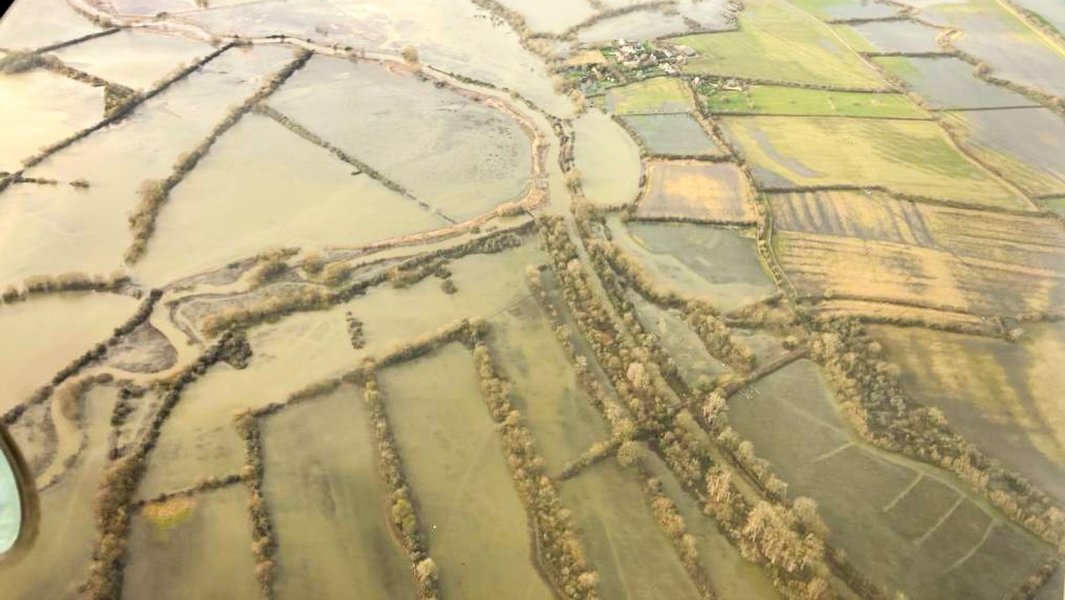
A vibrant floodplain, illustrating its critical role as a diverse habitat for wildlife and vegetation.
Flood Risk Reduction and Water Management
Natural floodplains are nature's frontline defense against destructive floods. They possess several inherent functions that mitigate flood risks:
- Floodwater Storage: Floodplains allow floodwaters to spread out and temporarily store excess water, significantly reducing flood peaks and velocities. For example, one acre of floodplain flooded one foot deep can hold approximately 330,000 gallons of water. This capacity is particularly important in urban areas downstream.
- Flow Rate and Erosion Reduction: The vegetation and natural topography of floodplains slow down the rate at which overland flow reaches the main water body. This helps dissipate the energy of floodwaters, minimizing erosion of riverbanks and surrounding land.
- Groundwater Recharge: Floodplains facilitate the permeation of water into the ground, recharging freshwater aquifers. As floodwaters seep through layers of sediment, they undergo natural filtration, often resulting in high-quality groundwater.
Water Quality Improvement
Floodplains act as natural filters, retaining sediments and nutrients that would otherwise flow downstream and potentially degrade water quality. They play a vital role in regulating nutrient cycles, especially phosphorus, by facilitating biological uptake in floodplain forests and mediating its transformation depending on ambient conditions. This retention of pollutants helps maintain cleaner water for both human consumption and aquatic ecosystems.
Soil Fertility and Agricultural Productivity
The deposition of nutrient-rich silt and sediment during flood events significantly enhances soil fertility across the floodplain. This makes floodplains historically ideal for agricultural use, supporting productive farmlands in regions like the Nile and Mississippi river basins. The continuous replenishment of fertile soil is a key economic benefit.
Benefits at a Glance
The multifaceted advantages of healthy floodplains can be summarized in the following table:
| Benefit Category | Specific Benefits | Impact |
|---|---|---|
| Ecological Health | Habitat for diverse flora and fauna, nutrient exchange, biodiversity refuge. | Supports robust ecosystems and wildlife populations. |
| Flood Management | Floodwater storage, peak flow reduction, erosion control. | Minimizes flood damage, protects infrastructure, reduces downstream risks. |
| Water Quality | Sediment and nutrient retention, natural filtration, groundwater recharge. | Ensures cleaner water, maintains aquifer levels, purifies water naturally. |
| Economic & Social | Fertile agricultural land, recreational opportunities, natural aesthetics. | Supports agriculture, provides open space, enhances quality of life. |
| Resilience | Adaptation to climate change impacts, ecosystem stability. | Enhances community and environmental resilience against hazards. |
Human Interaction and Floodplain Management
Challenges and Conservation Efforts
Human settlements have historically gravitated towards river valleys and their associated floodplains due to their fertile soils and access to water. However, this proximity also brings challenges, especially concerning flood risk and the degradation of natural floodplain functions.
Impacts of Human Activities
Rapid urbanization and agricultural expansion often encroach on floodplain habitats, leading to the loss of natural areas. Development along river corridors significantly alters floodplain functions, increasing the frequency and severity of floods, fragmenting ecosystems, and impacting water supplies. Flood control measures like levees, while protecting human settlements, can disrupt the natural flood pulse, limiting the exchange of nutrients and organisms and reducing the ecological diversity of floodplains.
A radar chart comparing the ecological health and resilience of natural versus altered floodplains.
The radar chart above visually represents the comparative strengths of natural floodplains versus those significantly altered by human intervention (e.g., through extensive levee systems). Natural floodplains excel in their capacity for floodwater storage, support for biodiversity, nutrient retention, groundwater recharge, and overall ecosystem resilience. In contrast, altered floodplains often show a reduced capacity in these crucial ecological functions, highlighting the trade-offs involved in human development within these sensitive areas. While levee systems can provide localized protection from floods, they can also disconnect the river from its natural floodplain, diminishing the broader ecological benefits and potentially exacerbating flood impacts downstream or when levees fail.
Floodplain Management and Conservation
Effective floodplain management is essential for balancing human needs with environmental protection. This involves a collaborative effort between communities and agencies like the Federal Emergency Management Agency (FEMA) in the U.S., which maps floodplains to designate areas susceptible to inundation. These Flood Insurance Rate Maps (FIRMs) inform land-use policies and development zones, guiding where and how construction can occur to minimize risk.
This video from Time for Geography visually explains the step-by-step formation of floodplains and levees, offering an excellent animated overview of the river processes involved in sculpting these landscapes.
Beyond mapping, conservation efforts focus on protecting and restoring natural floodplain functions. This includes acquiring environmentally sensitive lands, implementing deed restrictions on development in vulnerable areas, and restoring degraded floodplains to enhance their capacity for sediment and nutrient retention, floodwater storage, and habitat provision. The success of large-scale projects, such as the Mississippi Rivers and Tributaries Project, which integrates river and floodplain management, demonstrates the effectiveness of sustainable practices in mitigating flood risks while maintaining ecological integrity.
Common Questions About Floodplains
What is the primary definition of a floodplain?
How do floods contribute to the fertility of floodplains?
What are natural levees and how do they form?
Why are floodplains considered important ecosystems?
What is a "100-year floodplain" and what does it mean?
How does human development impact floodplains?
Conclusion
Floodplains are remarkable natural features, shaped by the powerful and intricate processes of rivers. Their formation through erosion and deposition creates a unique landscape that is not only susceptible to flooding but also exceptionally fertile and ecologically vibrant. These areas provide invaluable ecosystem services, from mitigating flood risks and purifying water to supporting rich biodiversity and offering fertile grounds for agriculture. Understanding the dynamic nature of floodplains and their critical functions is paramount for developing effective management strategies that balance human development with the preservation of these vital natural assets. Sustainable practices, including integrated river and floodplain management, are key to ensuring the long-term health and resilience of these important landscapes.
Recommended Further Exploration
- Explore how climate change is intensifying flood risks and altering floodplain ecosystems worldwide.
- Discover innovative strategies and successful case studies for managing and restoring floodplains.
- Delve deeper into the broader ecosystem services offered by healthy wetlands, often found within floodplains.
- Investigate the critical concept of hydrological connectivity and its importance for floodplain health.
References
Last updated May 21, 2025