
Unveiling Earth's Waterways: A Deep Dive into Fluvial Depositional Environments
Discover how rivers sculpt landscapes and leave behind intricate sedimentary records, with a special focus on the dynamic point bar.
Highlights
- Fluvial systems create diverse sub-environments: Rivers and streams form distinct areas of sediment deposition, including channels, floodplains, alluvial fans, and deltas, each with unique characteristics.
- Meandering river point bars are key depositional sites: These features form on the inner bends of river curves through a process of lateral accretion, resulting in characteristic fining-upward sedimentary sequences.
- Understanding fluvial deposits is crucial: Studying these environments helps interpret Earth's history, manage resources, and predict geological hazards.
Understanding Fluvial Systems: A World Shaped by Water
Fluvial systems, encompassing rivers and streams, are powerful agents of geological change. They tirelessly erode, transport, and deposit vast quantities of sediment, shaping the Earth's surface and creating a rich tapestry of landforms. The locations where these sediments accumulate are known as depositional environments, and within a broader fluvial system, several distinct sub-environments can be identified. Each sub-environment is characterized by specific energy conditions, sediment types, and resulting sedimentary structures, offering clues to past conditions and processes.
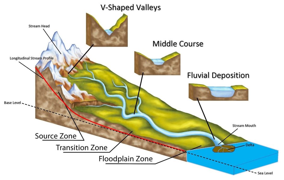
Spatial distribution of components within a fluvial system, illustrating the journey of sediment from source to depositional zones.
Key Depositional Sub-Environments in Fluvial Systems
Fluvial systems are mosaics of interconnected depositional settings. The primary energy of flowing water dictates where and how sediments are laid down. Here are some of the major sub-environments:
1. Channels
Channels are the primary conduits for water and sediment flow. Deposition within channels is dynamic and leads to various features.
Meandering Channels
Characterized by sinuous, curving paths, common in low-gradient rivers. They feature distinct erosional (cut banks) and depositional (point bars) zones. Sediments range from gravel and sand to silt and clay.
Braided Channels
These consist of multiple, interconnected shallow channels separated by bars or small islands (eyots). They typically occur in rivers with high sediment loads, steep gradients, and variable discharge. Deposits are often coarse-grained (sand and gravel) and can exhibit complex cross-bedding.
2. Floodplains (Overbank Environments)
Floodplains are relatively flat areas adjacent to river channels, built by sediments deposited during flood events when water overtops the channel banks. They are primarily composed of fine-grained sediments like silt and clay.
Natural Levees
Wedge-shaped ridges of coarser sediment (fine sand, silt) deposited along the immediate channel banks as floodwaters rapidly lose velocity upon leaving the main channel.
Backswamps
Low-lying, poorly drained areas on the floodplain located away from the main channel, behind natural levees. They accumulate fine silts and clays, and often organic matter, in quiet water conditions.
Crevasse Splays
Fan-shaped deposits of coarser sediment that form when a levee is breached during a flood, allowing water and sediment to spread onto the floodplain.
Oxbow Lakes and Infilled Channels
Abandoned meander loops that have been cut off from the main channel become oxbow lakes. Over time, these can fill with fine-grained sediment and organic matter, creating infilled channel deposits.
3. Alluvial Fans
These are cone- or fan-shaped deposits of sediment that form where a stream or river experiences a sudden decrease in slope and confinement, typically at the mouth of a canyon or where a mountain stream flows onto a flatter plain. Sediments are generally coarse-grained (boulders, gravel, sand) and poorly sorted.
4. Deltas
Deltas form where a river enters a standing body of water (lake, sea, or ocean), causing a rapid decrease in flow velocity and deposition of its sediment load. Fluvial-dominated deltas exhibit prograding lobes of sediment, with distributary channels branching out. Sediments range from sands at river mouths to fine muds in prodelta areas.
5. River Terraces
These are remnants of former floodplain surfaces that are now perched above the current river level. They form due to river incision, uplift, or changes in base level, and provide a record of past fluvial activity and landscape evolution.
Mapping the Connections: A Mindmap of Fluvial Sub-Environments
The following mindmap illustrates the relationships between the various depositional sub-environments within a typical fluvial system. Understanding these connections helps in deciphering the complex sedimentary architecture created by rivers.
Focus: The Meandering River Point Bar Depositional Model
Among the various fluvial sub-environments, the point bar deposits associated with meandering rivers offer a classic example of how fluvial processes sculpt the landscape and create distinctive sedimentary sequences. We will delve into the depositional model for this fascinating feature.
Context and Characteristics
Point bars are accumulations of sediment found on the inner, convex bank of meander bends in a river. They are a direct result of the river's sinuous flow pattern. As water flows around a bend, centrifugal force directs the fastest, most energetic flow towards the outer bank (cut bank), causing erosion. Conversely, the inner bank experiences reduced flow velocity, leading to sediment deposition and the growth of the point bar.
Sediments in point bars are typically well-sorted, ranging from coarser materials like gravel and sand at the base and channel-ward side, to finer sands, silts, and clays towards the top and floodplain-ward side. This gradation reflects the decreasing energy across the point bar surface.
The Depositional Process: A Dance of Erosion and Accumulation
The formation of a point bar is a dynamic process governed by several key mechanisms:
Helicoidal Flow
A crucial element in meander dynamics is helicoidal (corkscrew-like) flow. As water moves around a bend, a secondary current is established that spirals downwards at the outer bank, across the channel bed, and upwards at the inner bank. This flow pattern erodes sediment from the outer bank and transports it across the channel towards the inner bank, where it is deposited on the point bar.
Lateral Accretion
Point bars grow primarily through lateral accretion. This means sediment is added horizontally to the side of the existing bar as the channel migrates outward. Successive layers of sediment are deposited, building the bar out into the channel and contributing to the meandering river's characteristic sideways movement across its floodplain over time.
Fining-Upward Sequence
A hallmark of point bar deposits is a "fining-upward" sequence. The highest energy conditions are at the base of the channel and towards the thalweg (deepest part of the channel), allowing coarser sediments (gravel, coarse sand) to be deposited. As the point bar builds up and laterally, the depositional surface becomes shallower and flow velocity decreases. This results in progressively finer sediments (medium sand, fine sand, silt, clay) being deposited towards the top of the sequence. This vertical change in grain size is a key identifier of point bar deposits in the geological record.
Vegetation Colonization
As the upper parts of the point bar become more stable and less frequently inundated, vegetation may colonize the surface. Plant roots help to stabilize the newly deposited sediments and can trap finer particles during flood events, contributing to the development of floodplain soils on top of the point bar sequence.
Sedimentary Structures and Signatures
The varying flow conditions across a point bar create distinctive sedimentary structures. Common structures include:
- Trough cross-bedding and planar cross-bedding: Formed by the migration of dunes and ripples in sandy parts of the bar.
- Ripple marks: Small-scale bedforms indicative of lower flow velocities, often found in finer sands and silts. Asymmetrical ripples are common due to the directional flow.
- Laminations: Fine, parallel layers of silt and clay deposited from suspension during waning flow or flood events on the upper part of the bar.
Visualizing the Model: Point Bar Architecture
The image below showcases the complex internal architecture of downstream-migrating fluvial point bars as preserved in the rock record. It highlights the inclined surfaces (epsilon cross-stratification) that represent the successive growth stages of the point bar, a characteristic feature of lateral accretion.

Cross-sectional view of ancient fluvial point bar deposits, illustrating inclined sedimentary layers indicative of lateral accretion.
Comparative Characteristics of Fluvial Sub-Environments
Different fluvial sub-environments possess distinct characteristics based on their formation processes. The radar chart below provides a comparative visualization of selected attributes for key fluvial depositional settings. This helps in understanding their relative energy levels, typical sediment grain sizes, sediment sorting, potential for preserving sedimentary structures, and the lateral continuity of their deposits. The scale for each attribute is generally from 1 (low/fine/poor) to 10 (high/coarse/good).
Summary Table of Fluvial Depositional Sub-Environments
This table provides a concise summary of the key characteristics of the major fluvial depositional sub-environments discussed.
| Sub-Environment | Dominant Process(es) | Typical Sediments | Key Landforms/Features | Sedimentary Structures |
|---|---|---|---|---|
| Meandering Channel (Point Bar) | Lateral accretion, helicoidal flow | Sand, silt, gravel; fining upward | Point bars, cut banks, scroll bars | Cross-bedding (trough, planar), ripples, laminations |
| Braided Channel | Channel bar formation, channel shifting | Gravel, coarse sand | Longitudinal bars, transverse bars, multiple channels | Large-scale cross-bedding, scour-and-fill |
| Floodplain (General) | Overbank flow, suspension settling | Silt, clay, fine sand | Flat plains, natural levees, backswamps | Laminations, ripple marks, mudcracks, paleosols |
| Natural Levees | Rapid deposition from overbank flow near channel | Fine sand, silt | Ridges parallel to channel | Stratified sands, laminations |
| Backswamps | Suspension settling in low-energy areas | Clay, silt, organic matter | Low-lying, poorly drained areas | Fine laminations, organic layers |
| Crevasse Splays | Breaching of levees, rapid deposition | Sand, silt | Fan-shaped lobes on floodplain | Cross-bedding, normally graded beds |
| Alluvial Fans | Debris flows, sheetfloods, streamflow | Boulders, gravel, sand, silt (poorly sorted) | Cone-shaped deposits | Poorly defined bedding, graded bedding, imbrication |
| Deltas (Fluvial-Dominated) | River outflow, sediment progradation | Sand, silt, clay | Distributary channels, mouth bars, delta plain | Cross-bedding, laminations, climbing ripples |
| River Terraces | Former floodplain incision and abandonment | Variable, often sand and gravel capped with fines | Step-like benches above current river | Similar to floodplain/channel deposits of their time |
Real-World Examples of Meandering Rivers and Point Bars
The dynamic processes of meandering rivers and point bar formation are vividly illustrated by numerous rivers around the globe. Some iconic examples include:
- The Mississippi River, USA: A classic example of a large, meandering river system with extensive floodplains and well-developed point bars. Its deposits have been extensively studied and contribute significantly to the agricultural richness of the region.
- The Amazon River, South America: The world's largest river by discharge, the Amazon exhibits vast meanders and enormous point bar complexes, continually reshaping its course through the rainforest.
- The Ganges and Brahmaputra Rivers, India/Bangladesh: These rivers carry immense sediment loads from the Himalayas, forming extensive meanders, floodplains, and one of the world's largest deltas. Their point bars contribute to fertile lands vital for agriculture.
Exploring Fluvial Environments Visually
The video below discusses sedimentary facies within fluvial environments, providing a closer look at the deposits formed by meandering and braided rivers. This offers valuable context for understanding the concepts discussed, particularly relating to point bar formation in meandering systems and the resulting sedimentary characteristics.
This exploration of sedimentary facies helps to bridge the gap between theoretical models and what geologists observe in ancient rock formations, reinforcing the significance of point bars as indicators of past river systems.
Frequently Asked Questions (FAQ)
Recommended Queries
- How do sedimentary structures in point bars indicate flow direction?
- What are the economic importances of fluvial sandstones?
- Compare and contrast fluvial-dominated deltas with wave-dominated deltas.
- How does climate change affect fluvial systems and their depositional patterns?
References
Last updated May 13, 2025