
Unlocking Earth's River Histories: A Deep Dive into Fluvial Depositional Models
Exploring how rivers sculpt landscapes and leave behind geological clues through sediment deposition.
Fluvial systems, encompassing rivers and streams, are dynamic environments that play a crucial role in shaping the Earth's surface. They erode, transport, and deposit vast quantities of sediment, creating a diverse array of landforms and sedimentary sequences. Understanding the depositional models within these systems is paramount for geologists, environmental scientists, and engineers, as these models provide a framework for interpreting ancient sedimentary rocks, predicting the distribution of natural resources like hydrocarbons and groundwater, and managing modern riverine environments.
Essential Insights into Fluvial Deposition
- Channel Dynamics Dictate Deposition: The type of river channel (e.g., meandering, braided) significantly influences how and where sediments are deposited, leading to distinct architectural patterns in the rock record.
- Layered Clues (Facies): Fluvial deposits are characterized by specific sedimentary facies—rock units with distinct lithology, textures, and structures—that reveal the processes and conditions of their formation, often showing fining-upward sequences.
- External and Internal Controls: Fluvial deposition is governed by a complex interplay of external (allogenic) factors like climate, tectonics, and sea-level changes, and internal (autogenic) processes such as channel migration and avulsion.
The journey of sediment through a fluvial system, from source to sink.
The Building Blocks: Components of Fluvial Systems
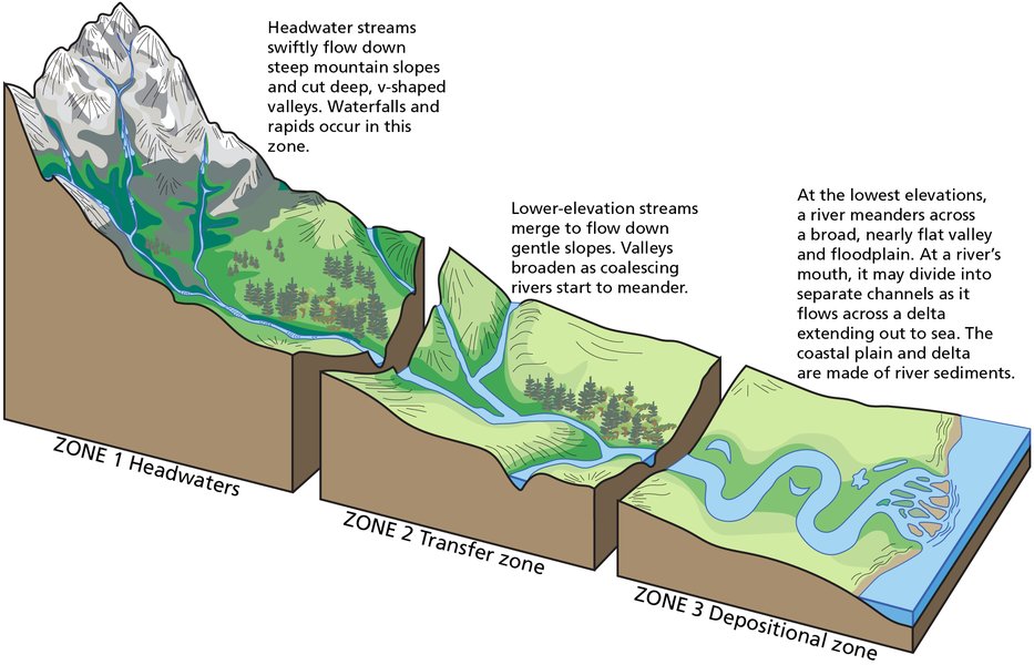
A comprehensive understanding of fluvial depositional models begins with recognizing the fundamental components of a fluvial system. These systems are generally considered to have three primary parts:
- Drainage Basin (Source Area): This is where water and sediment originate. The geology, topography, and climate of the drainage basin determine the type and volume of sediment supplied to the river.
- River Channel (Conduit): This is the primary pathway for water and sediment transport. The characteristics of the channel, such as its shape, size, and gradient, evolve as it traverses the landscape.
- Depositional Environments: These are areas where the river loses energy and deposits its sediment load. Key depositional environments include floodplains, point bars, channel fills, alluvial fans, and deltas (though deltas are often considered transitional environments between fluvial and marine/lacustrine systems).
River Channel Morphologies and Their Depositional Signatures
The morphology of a river channel is a primary control on depositional patterns. Different channel types create distinct sedimentary architectures.
Meandering River Systems
Meandering rivers are characterized by a single, sinuous channel that winds its way across a floodplain. Key depositional features include:
- Point Bars: Accumulations of sediment, typically sand and gravel, on the inner bends of meanders where flow velocity is lower. These often exhibit characteristic fining-upward sequences and cross-bedding.
- Cut Banks: Actively eroding outer banks of meanders.
- Oxbow Lakes: Abandoned meander loops that become filled with fine-grained sediment over time.
- Floodplains: Broad, flat areas adjacent to the channel, primarily composed of fine-grained sediments (silt and clay) deposited during flood events (overbank deposition). Natural levees, slightly elevated ridges of coarser sediment, may form along channel margins.
- Crevasse Splays: Fan-shaped deposits formed when a river breaches its levee during a flood, depositing coarser sediment onto the floodplain.
Braided River Systems
Braided rivers consist of a network of multiple, interconnected, and relatively shallow channels separated by bars or small islands (braid bars). They are common in environments with high sediment loads (often coarse-grained), steep gradients, and variable discharge. Depositional characteristics include:
- Longitudinal and Transverse Bars: Accumulations of gravel and sand within the channels that shift frequently.
- Complex Channel Fills: Deposits are often laterally variable and can consist of stacked sequences of bar and channel-fill sediments.
- Limited Floodplain Development: Well-defined floodplains are often less extensive than in meandering systems due to frequent channel shifting.
Anastomosing River Systems
Anastomosing rivers are characterized by multiple, interconnected channels that are relatively stable and separated by vegetated islands or floodplain segments. They typically occur in low-gradient settings with high aggradation rates.
- Stable Channels and Islands: Channels tend to be more fixed compared to braided systems.
- Abundant Overbank Fines: Significant deposition of fine-grained sediment (silt and clay) on the intervening floodplains and islands.
- Organic-Rich Deposits: Common due to stable, vegetated islands and floodplains.
Straight River Systems
Naturally straight channels are rare over long distances but can occur in structurally controlled settings or where gradients are very steep. Deposition in these systems can be localized, often associated with subtle changes in flow velocity or channel geometry.
Deciphering the Past: Sedimentary Facies and Structures
Fluvial depositional models rely heavily on the analysis of sedimentary facies – bodies of rock with specific characteristics (lithology, texture, sedimentary structures) that reflect a particular depositional environment. Common fluvial lithofacies are described based on grain size (e.g., gravel, sand, mud) and the sedimentary structures they contain.
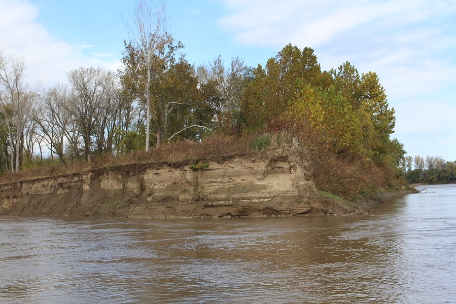
Layers of fluvial sediment, each telling a story of past river conditions.
Key sedimentary structures include:
- Cross-bedding: Inclined layers within a larger bed, indicative of migrating bedforms like ripples and dunes, common in channel and point bar deposits.
- Graded bedding: A gradual change in grain size within a single bed, often fining upwards as flow energy wanes.
- Ripple marks: Small-scale ridges formed by flowing water on sediment surfaces.
- Channel lag deposits: Coarse-grained material left at the base of a channel after finer sediments have been winnowed away.
- Mudcracks and Paleosols: Features indicative of subaerial exposure and soil development on floodplains.
Fining-upward sequences are a hallmark of many fluvial environments, particularly in meandering systems, reflecting the lateral migration of channels over floodplains or the gradual abandonment and filling of channels.
Key Fluvial Depositional Models
Geologists have developed various models to conceptualize and predict the architecture of fluvial deposits. These models integrate observations from modern rivers and ancient rock successions.
Facies Models
Facies models are generalized representations of sedimentary environments, summarizing the characteristic assemblage of facies, their geometries, and spatial relationships. For fluvial systems, these models help in interpreting depositional processes. Quantitative facies models utilize databases to generate statistical information on proportions, geometries, and grain sizes of genetic units (e.g., channel bodies, floodplain deposits).
Models Based on Climate and Sediment Load
Climate and sediment load profoundly influence fluvial style and deposition. For example:
- Arid-Climate Braided Stream Complexes: Characterized by coarse sediment load, highly variable discharge, and ephemeral flow, leading to extensive, poorly sorted deposits (e.g., the Realitos-Mathis model for the Goliad Formation).
- Semi-Arid Coarse-Grained Meander Belts: Develop in areas with extensive, low-relief floodplains and can produce mixed-load deposits (e.g., the Cuero-Eagle Lake model).
Distributive Fluvial Systems (DFS)
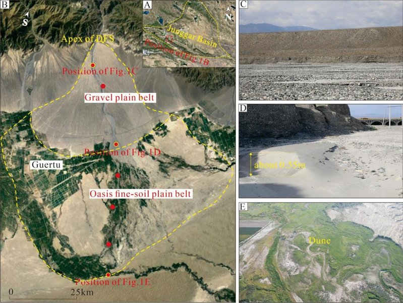
Conceptual model of a Distributive Fluvial System, showing fan-like sediment dispersal.
DFS models describe fan-shaped sediment bodies where rivers spread out and deposit sediment across a broad area, such as at the margin of a basin or where a river enters a larger plain. These systems are characterized by prograding channels, avulsions (channel switching), and the preservation of floodplain wedges. Alluvial fans are a common type of DFS.
Sequence Stratigraphy in Fluvial Systems
Sequence stratigraphy provides a framework for understanding the large-scale architecture of sedimentary basins and how it is controlled by factors like tectonic subsidence, climate change, and eustatic (sea-level) fluctuations. In fluvial systems, these controls influence accommodation space (the space available for sediment accumulation). For instance, during periods of rising base level (e.g., sea-level rise), rivers may aggrade (build up vertically), leading to thicker fluvial sequences and increased floodplain sediment storage. Avulsions and channel belt aggradation are key processes in shaping fluvial sequence stratigraphy.
Geomorphic and Stochastic Models
Geomorphic models focus on the evolution of the fluvial landscape over time. Stochastic models, like ALLUVSIM, use event-based simulations to mimic the randomness and complexity of fluvial deposition, helping to create more realistic subsurface models, particularly for reservoir characterization.
Visualizing Fluvial System Characteristics
The following chart compares hypothetical relative scores for key characteristics across different types of fluvial systems. These are generalized comparisons to illustrate the contrasting natures of these environments. For example, braided rivers typically exhibit higher energy and coarser sediment compared to meandering rivers, which have higher sinuosity.
This radar chart visually contrasts generalized characteristics of meandering, braided, and anastomosing fluvial systems. For instance, "Energy Level" and "Sediment Grain Size" are typically higher in braided systems, while "Sinuosity" and "Channel Stability" tend to be higher in meandering and anastomosing systems, respectively. "Overbank Deposition Extent" is usually significant in both meandering and anastomosing systems.
Interconnected Elements of Fluvial Deposition
The various components and processes within fluvial systems are intricately linked. The mindmap below illustrates some of these key relationships, from the overarching system to specific depositional features and controlling factors.
(Floodplains, Deltas, etc.)"] id2["Channel Types"] id2a["Meandering"] id2a1["Point Bars"] id2a2["Oxbow Lakes"] id2a3["Fining-Upward Sequences"] id2b["Braided"] id2b1["Braid Bars"] id2b2["Multiple Channels"] id2b3["Coarse Grained Deposits"] id2c["Anastomosing"] id2c1["Stable Channels"] id2c2["Fine-Grained Overbank"] id2d["Straight"] id3["Depositional Processes & Features"] id3a["Erosion & Transport"] id3b["Deposition Mechanisms"] id3c["Sedimentary Facies"] id3d["Key Landforms
(Levees, Crevasse Splays, Alluvial Fans)"] id4["Controlling Factors"] id4a["Allogenic (External)"] id4a1["Climate"] id4a2["Tectonics (Subsidence)"] id4a3["Base-Level Changes (Eustasy)"] id4a4["Sediment Supply"] id4b["Autogenic (Internal)"] id4b1["Channel Migration"] id4b2["Avulsion (Channel Switching)"] id4b3["Flood Events"] id5["Depositional Models"] id5a["Facies Models"] id5b["Sequence Stratigraphy"] id5c["Distributive Fluvial Systems (DFS)"] id5d["Climate/Load-Based Models"] id6["Applications"] id6a["Hydrocarbon Exploration"] id6b["Groundwater Management"] id6c["Environmental Reconstruction"] id6d["Engineering & Hazard Assessment"]
This mindmap conceptualizes "Fluvial Depositional Systems" at its core, branching out into major aspects like "Components" (such as the drainage basin and channel), "Channel Types" (meandering, braided, etc.) with their characteristic features (like point bars or braid bars). It further links to "Depositional Processes & Features" (including sedimentary facies and landforms), "Controlling Factors" (both external like climate and tectonics, and internal like avulsion), various "Depositional Models" (such as facies models and sequence stratigraphy), and finally, the "Applications" of understanding these systems (e.g., resource exploration).
Summary Table: Fluvial Channel Types and Characteristics
The following table summarizes the basic fluvial channel types based on common classification indices and their general depositional characteristics. Understanding these distinctions is fundamental to applying appropriate depositional models.
| Channel Type | Braided Parameter (B.P.) | Sinuosity Index | Typical Sediment | Key Depositional Features | Energy Level |
|---|---|---|---|---|---|
| Straight | <1 (single-channel) | Low (<1.5) | Variable, often coarser | Localized bars, limited floodplain | Moderate to High |
| Meandering | <1 (single-channel) | High (≥1.5) | Sand, silt, clay | Point bars, oxbow lakes, extensive floodplains, fining-upward sequences | Low to Moderate |
| Braided | ≥1 (multiple-channel) | Low (<1.5) | Gravel, sand | Multiple bars (longitudinal, transverse), channel fills, limited fine overbank | High |
| Anastomosing | ≥1 (multiple-channel) | High (≥1.5) | Silt, clay, sand, organics | Stable vegetated islands, deep narrow channels, extensive fine-grained overbank deposits | Low |
This table provides a comparative overview of different fluvial channel types based on their morphological parameters (Braided Parameter and Sinuosity Index), typical sediment characteristics, key depositional features they produce, and general energy levels associated with them. For example, meandering rivers are single-channel systems with high sinuosity, typically depositing finer sediments and forming features like point bars, while braided rivers are multi-channel, low sinuosity systems associated with coarser sediments and high energy.
Exploring Fluvial Processes Visually
The video below provides an excellent overview of fluvial processes, deposition, sedimentary structures, and stratigraphy, offering visual explanations that complement the concepts discussed. It helps to illustrate how sediments are deposited by rivers and how these deposits are interpreted by geologists.
This "GEO GIRL" video titled "Fluvial Depositional Environments & Stratigraphy" delves into the core aspects of how rivers work to shape landscapes through sediment movement and accumulation. It covers fundamental fluvial processes, the nature of deposition, the types of sedimentary structures that form (like cross-bedding and ripple marks), and how these elements contribute to the overall stratigraphy, or layering, observed in fluvial deposits. Such visual aids are invaluable for understanding the dynamic interplay of factors that create the geological record of ancient river systems.
Importance and Applications
The study of fluvial depositional models has significant practical applications:
- Hydrocarbon Exploration and Production: Fluvial sandstones are important reservoir rocks for oil and gas. Understanding their geometry, connectivity, and internal heterogeneity is crucial for successful exploration and efficient recovery. Models help predict the location and quality of these reservoir bodies.
- Groundwater Management: Fluvial deposits often form productive aquifers. Depositional models aid in understanding aquifer architecture, hydraulic conductivity, and contaminant transport pathways.
- Environmental and Paleoenvironmental Reconstruction: Ancient fluvial deposits provide valuable records of past climates, landscapes, and tectonic activity.
- Civil Engineering and Hazard Assessment: Knowledge of fluvial processes and deposits is essential for river management, flood control, bridge and dam construction, and assessing risks associated with river migration and sedimentation.
- Mineral Exploration: Certain types of fluvial deposits (placers) can concentrate heavy minerals like gold and diamonds.
Frequently Asked Questions (FAQ)
Recommended Further Exploration
- How does climate change impact fluvial depositional patterns in modern rivers?
- What are the key differences in reservoir characteristics between meandering and braided fluvial sandstones?
- Can you explain the concept of accommodation space in fluvial sequence stratigraphy?
- How are ancient fluvial deposits used to reconstruct paleoclimates?
References
 igcsegeography.wordpress.com
Last updated May 7, 2025