
Unveiling Earth's Riverine Architects: How Fluvial Environments Sculpt Landscapes
Explore the dynamic processes of sediment transport and deposition by rivers, shaping the very ground beneath our feet.
Highlights of Fluvial Systems
- Dynamic Sculptors: Rivers are powerful agents of change, constantly eroding, transporting, and depositing sediments to create a diverse array of landforms like alluvial fans, floodplains, and deltas.
- Sediment's Journey: The type and amount of sediment (gravel, sand, silt, clay) carried and deposited by a river are determined by its energy, which is influenced by factors like flow velocity, gradient, and discharge.
- Geological & Ecological Archives: Fluvial deposits preserve valuable records of past environmental conditions, serve as important groundwater aquifers, host hydrocarbon resources, and support unique ecosystems.
What are Fluvial Depositional Environments?
Fluvial depositional environments encompass all settings on land where sediments are transported and deposited by the action of rivers and streams. The term "fluvial" originates from the Latin word "fluvius," meaning river. These environments are dynamic systems where the interplay of water flow and sediment supply sculpts the landscape, creating a variety of recognizable landforms and sedimentary sequences. Understanding these environments is crucial for interpreting Earth's geological history, managing water resources, assessing natural hazards like floods, and exploring for economic deposits such as sand, gravel, and hydrocarbons.
The processes within these environments are primarily driven by the river's energy. This energy dictates the river's ability to erode its banks and bed, transport sediment particles of varying sizes, and ultimately deposit these sediments when its energy decreases.
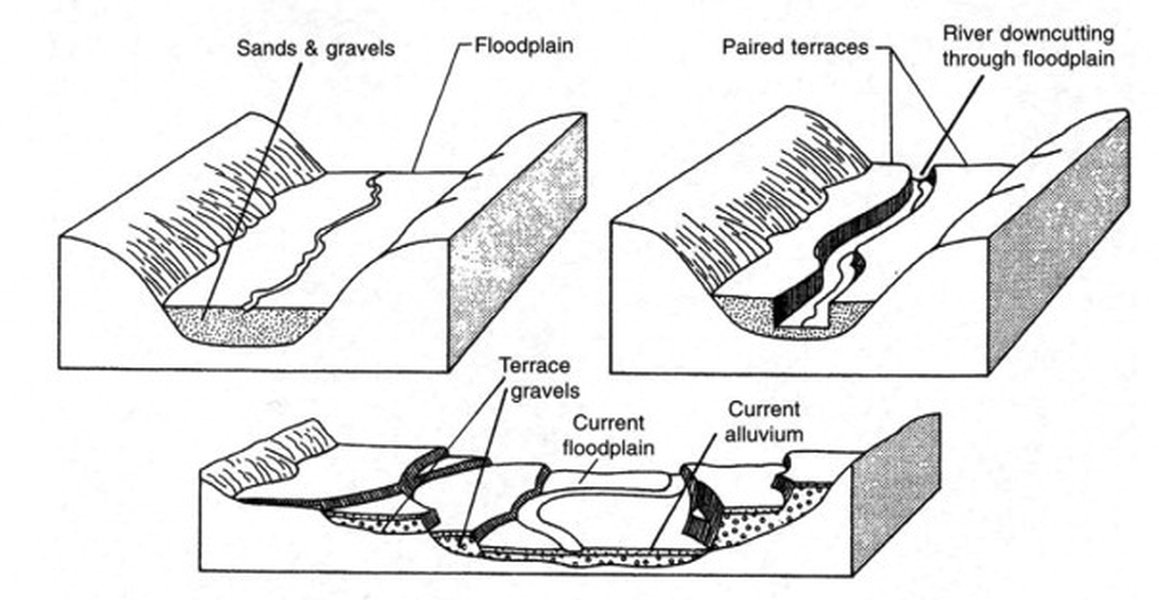
An illustrative overview of different fluvial depositional settings, from mountain fronts to broader plains.
The Journey of Sediment: From Source to Sink
Sediment in fluvial systems undergoes a three-stage journey: erosion, transportation, and deposition. This journey is fundamental to shaping the Earth's surface and creating the sedimentary rocks that record its history.
Erosion: The Starting Point
Erosion is the process by which rock and soil particles are dislodged from the Earth's surface. In fluvial environments, this primarily occurs through the hydraulic action of flowing water, abrasion by particles already carried by the river, and corrosion (chemical weathering). The rate and type of erosion depend on the river's velocity, the nature of the bedrock and bank materials, and the sediment load it already carries.
Transportation Mechanisms
Once eroded, sediment is transported downstream by the river in several ways, depending on particle size and flow velocity:
- Dissolved Load: Minerals dissolved in the water, often derived from chemical weathering. This load is invisible.
- Suspended Load: Fine particles like clay and silt are kept in suspension by the turbulence of the flowing water, giving the water a muddy appearance.
- Bedload: Coarser particles like sand and gravel that are too heavy to be suspended are moved along the riverbed. This occurs through:
- Traction: Larger boulders and cobbles roll or slide along the bed.
- Saltation: Smaller pebbles and sand grains bounce along the riverbed.
A river's competence refers to the maximum particle size it can transport, while its capacity is the total amount of sediment it can carry. Both are directly related to the river's velocity and discharge.
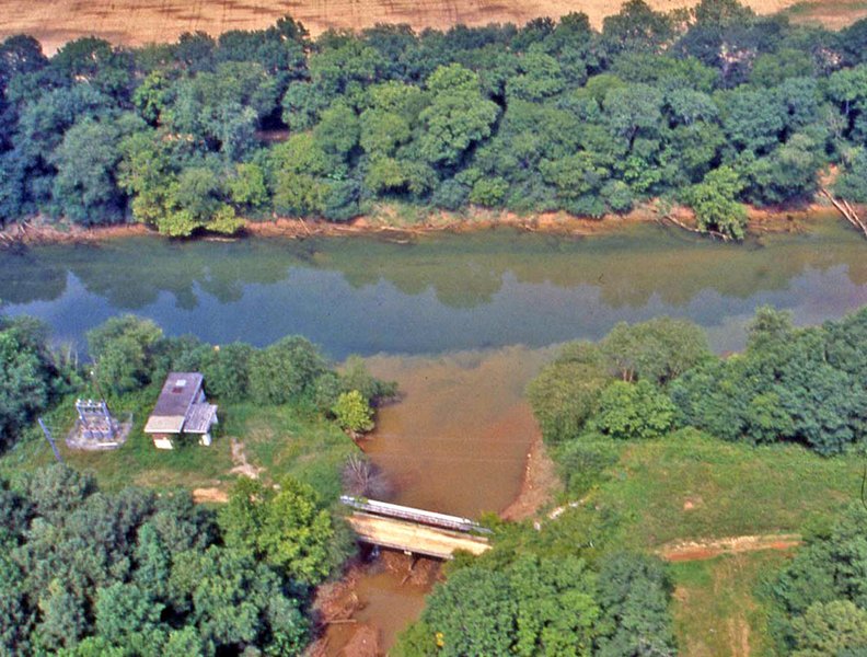
Visual evidence of sediment transport as a murky, sediment-rich tributary joins a clearer river, highlighting the deposition that can occur at confluences due to changes in flow dynamics.
Deposition: The Settling Process
Deposition occurs when a river loses energy and can no longer transport its sediment load. This typically happens when the velocity decreases due to a reduction in gradient (slope), a decrease in discharge (volume of water), or when the river enters a standing body of water like a lake or ocean. Heavier particles are deposited first, followed by progressively finer materials as the energy continues to wane. The critical erosion velocity is the minimum velocity required to pick up and transport a particle of a given size; when velocity drops below this (or more precisely, the settling velocity), deposition occurs.
Key Fluvial Depositional Environments and Their Characteristics
Fluvial systems create a variety of distinct depositional environments, each with characteristic sediments, landforms, and sedimentary structures.
Alluvial Fans
Alluvial fans are cone-shaped or fan-shaped deposits of sediment that form where a fast-flowing river or stream emerges from a steep, narrow mountain valley onto a flatter, broader plain or basin. The abrupt decrease in gradient and confinement causes the river to lose energy rapidly, depositing its coarse sediment load (boulders, cobbles, gravel, and sand). Deposits are typically poorly sorted and can include debris flow deposits in more arid or tectonically active regions.
Braided Rivers
Braided rivers are characterized by a network of multiple, shallow channels that split and rejoin, separated by islands or bars of sediment (typically sand and gravel). They form in areas with high sediment loads, steep gradients, and variable discharge. The channels are highly dynamic and shift frequently. Deposits consist mainly of coarse-grained sediments, often showing trough cross-bedding and planar bedding from the migration of bars and dunes.
Meandering Rivers
Meandering rivers are characterized by single, sinuous (winding) channels that flow across relatively flat plains with gentle gradients. Erosion occurs on the outer banks of meanders (cut banks) where velocity is highest, while deposition occurs on the inner banks (point bars) where velocity is lowest. Point bars typically consist of sand and gravel at the base, fining upwards to silt and clay. Over time, meanders migrate across the floodplain and can be cut off to form oxbow lakes.
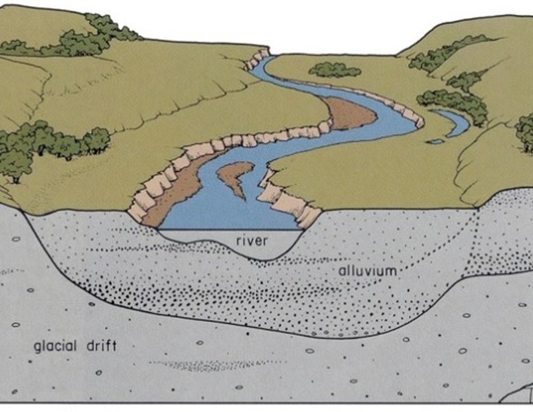
A classic example of a meandering river system with well-developed alluvial plains, showcasing features like meander bends and potential floodplain deposits.
Floodplains
Floodplains are broad, flat areas of land adjacent to a river channel, formed by the deposition of fine-grained sediments (silt and clay) during periods of flooding when the river overtops its banks. Key features of floodplains include:
- Natural Levees: Ridges of coarser sediment (sand and silt) built up along the immediate river banks, deposited as floodwaters first lose energy upon leaving the main channel.
- Backswamps: Poorly drained, low-lying areas on the floodplain behind natural levees, where fine clays and organic matter accumulate.
- Crevasse Splays: Fan-shaped deposits of coarser sediment that form when a levee is breached during a flood, allowing water and sediment to spread out onto the floodplain.
Deltas (Fluvial-Dominated)
Deltas form where a river enters a standing body of water (lake, sea, or ocean), causing a rapid decrease in velocity and deposition of its sediment load. Fluvial-dominated deltas occur when the river's sediment supply and depositional processes are stronger than wave or tidal action. They are characterized by prograding (building outwards) lobes of sediment, with distributary channels that spread sediment across the delta plain. Deposits typically show a coarsening-upward sequence as the delta builds out into the water body.
Incised-Valley Fills
Incised valleys are river valleys that have been cut down (eroded) significantly, often due to a fall in relative sea level or tectonic uplift. When conditions change (e.g., sea level rises again), these valleys can become filled with fluvial sediments, creating incised-valley fill deposits. These deposits can preserve a complex history of river response to external controls.
Tell-Tale Signs: Sedimentary Structures in Fluvial Deposits
The sediments deposited in fluvial environments often preserve characteristic sedimentary structures that provide clues about the flow conditions (velocity, direction, depth) at the time of deposition. Common structures include:
- Cross-bedding: Inclined layers within a larger bed, formed by the migration of ripples or dunes. Trough cross-bedding (curved, scoop-shaped sets) is common in channels, while planar cross-bedding (tabular sets) can also occur.
- Ripple Marks: Small-scale ridges and troughs formed on sandy surfaces by flowing water (current ripples) or oscillating water (wave ripples, less common in purely fluvial settings).
- Graded Bedding: A single bed showing a progressive change in grain size, typically fining upwards as flow energy wanes.
- Fining-Upward Sequences: Vertical successions of sediment where grain size decreases upwards. Common in point bar deposits (gravel/sand to silt/clay) and some crevasse splay deposits.
- Imbrication: Platy or elongate pebbles and cobbles that overlap each other, dipping upstream, indicating current direction.
- Mud Cracks: Polygonal patterns formed when muddy sediment dries and shrinks, common on floodplains exposed to air.
Visualizing Fluvial Dynamics: A Comparative Overview
Different fluvial environments exhibit distinct characteristics based on energy levels, sediment types, and depositional processes. The radar chart below provides a comparative visualization of these attributes across several key fluvial settings. Each axis represents a specific characteristic, and the plotted shape for each environment offers a quick glance at its overall nature. For instance, higher energy environments typically deposit coarser grains and may have less stable channels, while lower energy settings are associated with finer sediments and more stable features.
This chart helps illustrate, for example, that alluvial fans are high-energy environments with coarse, poorly sorted sediment, while floodplains are low-energy environments characterized by fine, well-sorted sediment and high preservation potential for delicate structures.
Mapping the Fluvial System: A Conceptual Framework
Fluvial depositional systems are complex, involving interconnected processes, environments, and resulting sedimentary features. The mindmap below provides a conceptual overview, linking the core components of fluvial systems, from the fundamental processes of erosion, transportation, and deposition to the diverse environments they create and the characteristic sediments and structures found within them. It also touches upon the factors controlling these systems and their broader significance. This visual framework helps in understanding the multifaceted nature of how rivers shape landscapes.
(Hydraulic Action, Abrasion)"] id1b["Transportation"] id1b1["Bedload (Traction, Saltation)"] id1b2["Suspended Load"] id1b3["Dissolved Load"] id1c["Deposition
(Velocity Decrease)"] id2["Key Environments"] id2a["Alluvial Fans
(Mountain Fronts)"] id2b["Braided Rivers
(High Energy, Multiple Channels)"] id2c["Meandering Rivers
(Sinuous Channels, Lower Energy)"] id2c1["Point Bars
(Inner Bends)"] id2c2["Floodplains
(Overbank Deposits)"] id2c2a["Natural Levees"] id2c2b["Backswamps"] id2c2c["Crevasse Splays"] id2d["Deltas (Fluvial-Dominated)
(River Mouths)"] id2e["Incised-Valley Fills"] id3["Sediment Characteristics"] id3a["Grain Size (Gravel, Sand, Silt, Clay)"] id3b["Sorting (Poor to Moderate)"] id3c["Sedimentary Structures"] id3c1["Cross-bedding (Trough, Planar)"] id3c2["Ripple Marks"] id3c3["Graded Bedding"] id3c4["Fining-Upward Sequences"] id3c5["Mud Cracks"] id4["Controlling Factors"] id4a["River Discharge & Velocity"] id4b["Sediment Load & Type"] id4c["Gradient & Topography"] id4d["Climate (Precipitation, Weathering)"] id4e["Tectonics (Uplift, Subsidence)"] id4f["Base Level (e.g., Sea Level)"] id5["Significance"] id5a["Geological Record (Paleoenvironment Reconstruction)"] id5b["Economic Resources (Water, Aggregates, Hydrocarbons, Placer Deposits)"] id5c["Ecological Habitats & Biodiversity"] id5d["Natural Hazards (Flooding, Channel Migration)"] id5e["Soil Formation"]
Navigating this mindmap allows one to trace the connections between, for example, how a river's gradient (a controlling factor) influences its energy, which in turn determines the type of environment (like a braided or meandering river) and the resulting sediment characteristics.
Factors Influencing Fluvial Deposition
Several interconnected factors govern the nature and extent of fluvial deposition:
River Characteristics
Gradient (Slope): Steeper gradients generally mean higher velocities and coarser sediment transport. As gradients decrease, so does energy, leading to deposition. Discharge: The volume of water flowing through a channel per unit time. Higher discharge means more energy available for erosion and transport. Velocity: The speed of water flow, critical for determining whether sediment is eroded, transported, or deposited. Channel Geometry: The shape, size, and roughness of the river channel influence flow velocity and turbulence.
Sediment Supply and Type
The availability and characteristics (size, shape, density) of sediment from the drainage basin significantly impact what a river transports and deposits. Rivers with abundant coarse sediment may form braided patterns, while those with more fine sediment might meander across floodplains.
Climate and Tectonics
Climate influences weathering rates (sediment production), vegetation cover (which affects erosion and sediment yield), and precipitation patterns (river discharge). Arid climates might favor alluvial fans, while humid climates support more extensive floodplain development. Tectonic activity can alter river gradients through uplift or subsidence, create accommodation space for sediment accumulation in basins, and influence the overall landscape through which rivers flow.
Broader Context and Significance
Fluvial depositional environments are not just geological curiosities; they play vital roles in Earth systems and human affairs.
Geological Record and Resource Exploration
Fluvial sediments, when lithified into sedimentary rocks (like sandstones and conglomerates), form a significant part of the geological record. They provide invaluable information about past climates, tectonic settings, and ancient landscapes. Porous and permeable fluvial sandstones are important reservoirs for groundwater and hydrocarbons (oil and natural gas). Placer deposits within fluvial sediments can also be sources of valuable minerals like gold and diamonds.
Ecological Importance
Riverine and floodplain ecosystems are among the most diverse and productive on Earth. The sediments deposited by rivers create fertile soils for agriculture and support unique riparian habitats. Water clarity, nutrient cycling, and physical habitat structure are all influenced by fluvial sediment dynamics.
Human Interactions and Management
Humans have long settled along rivers due to access to fresh water and fertile land. However, this proximity also brings challenges. Fluvial processes like flooding and channel migration can pose hazards. Human activities such as dam construction, deforestation, agriculture, and urbanization can drastically alter sediment loads and depositional patterns in rivers, often with unintended environmental consequences. Understanding fluvial systems is crucial for sustainable river management, flood control, and habitat restoration.
Distinguishing Fluvial from Other Environments
Geologists use various clues to differentiate ancient fluvial deposits from those formed in other environments (e.g., marine, lacustrine, eolian). These include the types of sedimentary structures, fossil content (terrestrial plants and animals vs. marine organisms), grain size trends, and even the geochemistry of fine-grained sediments. For instance, the relative proportions of sodium, calcium, and magnesium in clay minerals can help distinguish between freshwater fluvial clays and saltwater marine clays.
A Closer Look: Fluvial Processes in Action
The video below provides a dynamic exploration of fluvial processes, covering aspects of deposition, the formation of sedimentary structures, and the resulting stratigraphy (the layering of rocks). It helps visualize how rivers build up sequences of sediment over time, creating the fluvial deposits that geologists study to interpret Earth's history.
This overview of fluvial depositional environments and stratigraphy emphasizes the link between active river processes and the rock record they leave behind, which is fundamental to understanding sedimentary geology.
Comparative Table: Characteristics of Major Fluvial Environments
The following table summarizes the key characteristics of the major fluvial depositional environments discussed, offering a quick reference for their distinguishing features.
| Environment | Dominant Sediments | Key Processes | Characteristic Landforms/Structures |
|---|---|---|---|
| Alluvial Fans | Gravel, Sand (often poorly sorted), Mud (in debris flows) | Rapid deposition from confined to unconfined flow, debris flows, sheet floods | Cone/fan-shaped deposits, coarse-grained, often at mountain fronts, crude bedding, sieve deposits |
| Braided Rivers | Gravel, Sand | High energy, multiple shifting channels, bar migration, frequent avulsion | Interwoven channels, longitudinal/transverse bars, trough cross-bedding, planar bedding, lag deposits |
| Meandering Rivers | Sand (point bars), Silt, Clay (floodplains) | Lateral accretion (point bars), overbank flow, channel migration, cutoffs | Sinuous channels, point bars (fining-upward sequences), oxbow lakes, floodplains, natural levees, scroll bars, epsilon cross-stratification |
| Floodplains | Silt, Clay, Fine Sand (in levees/splays) | Overbank flooding, suspension settling, crevasse splay formation | Flat areas flanking rivers, natural levees, backswamps, crevasse splays, laminated muds, paleosols, root traces |
| Deltas (Fluvial-Dominated) | Sand, Silt, Clay | River mouth deposition, progradation, channel switching (avulsion), sediment bypassing | Distributary channels, mouth bars, delta plains, interdistributary bays, coarsening-upward sequences (prodelta to delta front to delta plain) |
Frequently Asked Questions (FAQ)
What is the difference between "fluvial" and "alluvial"?
"Fluvial" refers to processes related to rivers and streams (from Latin "fluvius" for river). "Alluvial" refers to the material (sediment like clay, silt, sand, and gravel) deposited by rivers and streams. So, fluvial processes create alluvial deposits. In practice, "fluvial deposits" and "alluvial deposits" are often used interchangeably to describe sediments laid down by rivers.
How do human activities impact fluvial sedimentation?
Human activities can significantly alter fluvial sedimentation. Dam construction traps sediment upstream, reducing supply downstream and potentially causing coastal erosion or clearer water that incises riverbeds. Deforestation, agriculture, and urbanization can increase soil erosion, leading to higher sediment loads in rivers, which can cause channels to aggrade (fill in), increase flood risk, and harm aquatic ecosystems. Channelization can increase flow velocities and sediment transport locally but may cause deposition issues elsewhere.
Why are fluvial deposits important for finding resources like oil and gas?
Fluvial deposits, particularly the sandy sediments found in channel fills and point bars, can form excellent reservoir rocks for oil and gas. These sands, when buried and lithified into sandstone, often possess good porosity (space to hold fluids) and permeability (ability to allow fluids to flow). If these reservoir rocks are appropriately sealed by impermeable layers (like floodplain mudstones) and situated within a geological trap, they can accumulate significant quantities of hydrocarbons.
What are some common sedimentary structures found in fluvial environments?
Common sedimentary structures in fluvial environments include cross-bedding (formed by migrating dunes and ripples in channels), ripple marks (on sandy surfaces), graded bedding (often in flood deposits), fining-upward sequences (characteristic of point bars), imbrication (alignment of pebbles indicating flow direction), and mud cracks (on exposed floodplain surfaces). These structures help geologists interpret ancient flow conditions and depositional settings.
How can geologists distinguish ancient fluvial deposits from marine deposits?
Geologists use several lines of evidence. Fossils are key: fluvial deposits may contain terrestrial plant remains, freshwater shells, or land animal bones, while marine deposits contain marine fossils (e.g., seashells, corals, foraminifera). Sedimentary structures can differ; for example, certain types of large-scale cross-bedding or specific trace fossils are more indicative of marine environments. The overall geometry of the deposit and its association with other rock types also provide clues. Clay mineralogy can also be diagnostic, as marine clays tend to have higher concentrations of certain ions (like sodium) compared to freshwater fluvial clays.
Recommended Further Exploration
- How does climate change affect fluvial systems and sediment transport?
- What are the main differences in deposits between braided and meandering rivers?
- Explore the role of fluvial geomorphology in river restoration projects.
- How are ancient fluvial environments identified in the rock record?
References
Last updated May 7, 2025