
Unraveling the Flow: How Do We Categorize the Earth's Arteries?
A deep dive into the diverse methods scientists use to classify rivers and streams, revealing the intricate order within these vital water systems.
Fluvial systems, the intricate networks of rivers, streams, and their associated landforms, are fundamental to shaping our planet's surface. They act as vital conduits for water and sediment, supporting diverse ecosystems and influencing human activities. Understanding these complex systems requires systematic classification, a cornerstone of geomorphology, hydrology, and environmental management. This exploration delves into the various ways fluvial systems are categorized, offering insights into their structure, behavior, and evolution.
Key Insights into Fluvial System Classification
- Classification is multifaceted, considering aspects like flow duration (perennial, intermittent, ephemeral), channel shape (meandering, braided, straight, anastomosing), and the patterns of tributary networks.
- Advanced systems like the Rosgen classification provide detailed frameworks based on quantifiable metrics such as channel entrenchment, gradient, sinuosity, and bed material, aiding in practical applications like river restoration.
- Geographic Information Systems (GIS) and remote sensing are increasingly used to automate and enhance the accuracy of classifying fluvial systems, allowing for large-scale analysis and mapping of river characteristics.
Defining Fluvial Systems
What Constitutes a Fluvial System?
A fluvial system encompasses the entire network of flowing water, including rivers and streams, along with the landforms they create and modify. This includes the source or headwaters where water collection begins, the channels through which water flows, the adjacent floodplains and terraces that signify zones of sediment deposition and erosion, and the mouths or deltas where rivers discharge into larger water bodies like lakes or oceans. These systems are inherently dynamic, constantly shaped by factors such as water discharge, sediment load, underlying geology, climate, and vegetation.
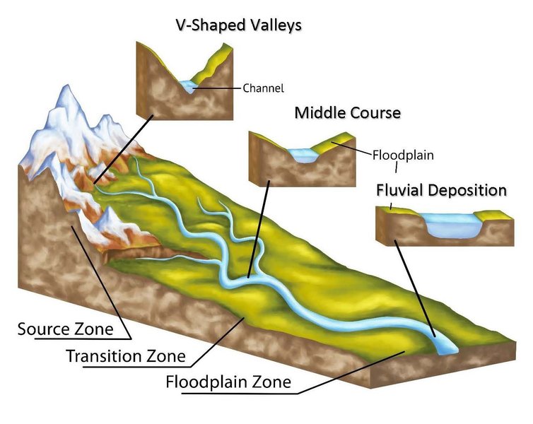
Anatomy of a typical stream, highlighting key components from source to mouth.
Primary Classification Criteria
Fluvial systems can be categorized based on several key characteristics, each providing a different lens through which to understand their behavior and morphology.
Based on Flow Permanence
How Consistently Does Water Flow?
The persistence of water flow is a fundamental classification criterion:
- Perennial Rivers: These rivers maintain a continuous flow throughout the year. They are typically found in humid climates with stable water sources, such as consistent rainfall or groundwater discharge.
- Intermittent/Periodic Rivers: These rivers flow only during specific seasons or periods, often corresponding to wet seasons or snowmelt. They may dry up completely during drier parts of the year.
- Ephemeral Rivers: Flowing only in direct response to precipitation events, ephemeral rivers are short-lived and characteristic of arid or semi-arid environments. Their channels may remain dry for extended periods.
Based on Channel Morphology and Pattern
What Shape Does the River Channel Take?
The physical form and pattern of a river channel are among the most visually distinct and commonly used classification features. These patterns are primarily influenced by the river's energy, sediment load, bank stability, and the slope of the land.
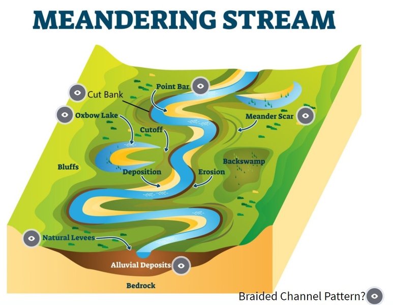
Common river channel patterns: straight, meandering, braided, and anastomosing.
- Straight Rivers: These channels exhibit a low sinuosity (they don't wind much). Naturally straight channels are relatively uncommon and are often found in steep, narrow valleys or where geological structures control the river's path. Many straight channels are human-made or heavily modified.
- Meandering Rivers: Characterized by a single, sinuous channel that winds its way across a floodplain. Meanders typically form in areas with gentle slopes and cohesive bank materials. Features like point bars (deposition on the inside of bends) and cut banks (erosion on the outside of bends) are common.
- Braided Rivers: These rivers consist of multiple, interconnected channels that are constantly shifting and are separated by bars or small islands (braid bars). Braided patterns are common in rivers with high sediment loads, variable discharge, and easily erodible banks, often found in mountainous regions or downstream of glaciers.
- Anastomosing Rivers: These systems feature multiple, interconnected channels that are relatively stable and separated by vegetated, semi-permanent islands. Unlike braided rivers, the islands in anastomosing systems are typically more stable and represent portions of the floodplain. They often occur in low-gradient environments with high sediment loads.
Based on Sediment Transport and Depositional Features
How Does the River Handle Sediment?
The way a river erodes, transports, and deposits sediment is another crucial aspect of its classification:
- Erosional Rivers: These rivers are primarily characterized by erosional processes, actively carving into the landscape to form valleys and canyons. They typically have higher energy and steeper gradients.
- Depositional Rivers: In these systems, sediment accumulation dominates over erosion. They are often found in lower gradient areas and are responsible for building landforms such as floodplains, levees, alluvial fans, and deltas.
- Fluvial-Distributive Systems (DFS): These are systems where a river branches out into multiple distributary channels, spreading water and sediment over a wide area. Deltas are a prime example of DFS, forming where rivers enter a standing body of water. DFS can be classified into proximal (near the source, high-energy), middle (transitional), and distal (low-energy, fan-like spreads) stages.
Based on Drainage Patterns
How Are Tributaries Arranged?
The geometric arrangement of a river and its tributaries forms a drainage pattern, which is largely influenced by the underlying geology and topography of the drainage basin.
- Dendritic: This is the most common pattern, resembling the branching of a tree. Tributaries join the main river at acute angles. It develops on relatively uniform bedrock or gently sloping terrain.
- Trellis: Characterized by a main river channel that is joined by tributaries at nearly right angles. Smaller tributaries often run parallel to the main river before joining. This pattern typically develops in areas with folded or tilted sedimentary rocks of varying resistance.
- Radial: Streams radiate outwards from a central high point, such as a volcano, dome, or isolated peak.
- Rectangular: Tributaries join others at right angles, and streams often make sharp, right-angled bends. This pattern develops in areas where bedrock is heavily jointed or faulted, and the fractures guide the stream courses.
- Parallel: Streams and their tributaries flow roughly parallel to one another over a considerable distance. This pattern often occurs on moderately steep slopes or in areas with parallel, elongated landforms.
Advanced and Formal Classification Systems
Beyond these basic classifications, more detailed and quantitative systems have been developed to provide a more nuanced understanding of fluvial systems, particularly for scientific research and river management.
The Rosgen Stream Classification System
A Widely Used Morphological Framework
Developed by Dave Rosgen, this system is widely used in North America for river assessment and restoration. It classifies streams into broad types (A through G, and DA for distributary anastomosing) based on several measurable channel characteristics:
- Entrenchment Ratio: The degree to which the river is incised into its valley floor.
- Width/Depth Ratio: The ratio of the bankfull channel width to its mean bankfull depth.
- Sinuosity: The ratio of channel length to valley length.
- Channel Slope: The gradient of the water surface.
- Channel Materials: The size and type of sediment found in the channel bed and banks (e.g., bedrock, boulder, cobble, gravel, sand, silt/clay).
Each stream type (e.g., A, B, C, D, E, F, G) reflects different channel stabilities, sediment transport capacities, and responses to disturbance. For example, "E" type streams are often highly sinuous, low-gradient, and sensitive to disturbance.
Geomorphological Classification Using GIS
Leveraging Technology for Analysis
Modern approaches increasingly utilize Geographic Information Systems (GIS) and remote sensing data (like satellite imagery and LiDAR) to classify fluvial systems. These tools allow for the automated or semi-automated extraction of geomorphic parameters (e.g., channel width, sinuosity, valley confinement, floodplain extent) over large areas. This enables more objective and repeatable classifications, crucial for large-scale inventories, monitoring changes over time, and understanding the hydromorphology (the physical character and condition) of rivers.
Hierarchical Classification
From Bedforms to Entire Systems
Some classification schemes adopt a hierarchical approach, recognizing that fluvial systems are composed of nested units at different scales. This can range from:
- Bed: The smallest individual sedimentary layers.
- Bed Set and Storey: Groups of beds forming larger structural units.
- Element: Distinct geomorphic features like bars, pools, or riffles.
- Complex: Assemblages of elements, such as a meander bend complex.
- System: The entire river system or a major reach.
This approach is particularly useful in sedimentology and stratigraphy for interpreting ancient fluvial deposits.
Interaction with Other Environmental Systems
Fluvial Systems in Broader Contexts
Fluvial systems don't exist in isolation. Classification systems have also been developed to describe their interaction with other geomorphic systems, such as aeolian (wind-driven) systems in desert environments. For instance, classifications may detail how fluvial channels penetrate dune fields, bifurcate around dunes, or how interdune corridors are flooded, considering factors like the orientation of dunes relative to river flow.
Visualizing Fluvial System Characteristics
The following chart provides a comparative overview of key characteristics for different morphological river types. The values are illustrative, representing general tendencies rather than precise measurements for any specific river. This helps visualize how different factors like sinuosity, sediment load, channel stability, gradient, and susceptibility to human impact vary across these common river forms.
This radar chart highlights, for instance, that braided rivers typically have low sinuosity but high sediment loads and bank erodibility, while meandering rivers show high sinuosity and moderate stability. Anastomosing rivers tend to be stable with multiple channels in low gradient settings.
Conceptual Overview of Fluvial Classification
The mindmap below offers a simplified visual summary of the main branches of fluvial system classification, showcasing the relationships between different criteria and types.
This mindmap illustrates how various factors, from the persistence of flow to complex morphological metrics, contribute to a comprehensive understanding and categorization of river systems.
Summary Table of Common Fluvial System Classifications
To consolidate the primary classification approaches, the following table outlines key criteria, the types or examples associated with them, and their distinguishing features.
| Classification Criterion | Types/Examples | Key Features |
|---|---|---|
| Flow Permanence | Perennial, Intermittent, Ephemeral | Continuity of water flow throughout the year or specific periods. |
| Channel Morphology/Pattern | Straight, Meandering, Braided, Anastomosing | Channel geometry, sinuosity, number of channels, and stability. Influenced by sediment load, slope, and bank material. |
| Sediment Transport/Deposition | Erosional, Depositional, Distributive (e.g., Deltas) | Dominant processes of sediment erosion, movement, and accumulation; formation of related landforms. |
| Drainage Patterns | Dendritic, Trellis, Radial, Rectangular, Parallel | Geometric arrangement of the main river and its tributaries, reflecting underlying geology and topography. |
| Formal Morphological Systems | Rosgen Stream Types (A-G), Buffington & Montgomery types | Quantitative metrics like entrenchment, width/depth ratio, sinuosity, slope, and bed material. |
| Scale/Hierarchy | Bed, Element, Complex, System | Categorization based on the scale of observation, from individual sedimentary layers to entire drainage basins. |
This table provides a quick reference to the diverse ways fluvial systems are analyzed and understood by scientists and environmental managers.
Exploring Fluvial Dynamics: An Introduction
The video below offers a foundational overview of fluvial systems, discussing their genetic classification and key terminologies. It serves as a good starting point for understanding the fundamental concepts related to rivers and their processes, which underpin the various classification methods discussed.
This video introduces basic concepts of fluvial systems, their formation, and classification components.
Understanding these introductory elements is crucial as it lays the groundwork for appreciating the complexity involved in how fluvial systems are categorized. Concepts such as sediment transport mechanisms (bedload, suspended load, dissolved load), channel geometry, and the energy dynamics of flowing water are all factors that contribute to the distinct characteristics used in classification schemes.
The Importance of Fluvial System Classification
Why Categorize Rivers?
The classification of fluvial systems is not merely an academic exercise; it has significant practical implications across various fields:
- River Management and Restoration: Understanding a river's type helps in designing effective restoration projects, managing flood risks, and maintaining navigation channels. For example, knowing if a stream is naturally a meandering or braided type informs restoration goals.
- Environmental Impact Assessment: Classifications aid in predicting how rivers might respond to human activities such as dam construction, urbanization, or agricultural practices.
- Ecological Studies: Different river types support different aquatic and riparian habitats. Classification helps in understanding biodiversity patterns and managing ecosystems.
- Water Resource Management: Knowledge of flow permanence and channel characteristics is vital for allocating water resources, predicting water availability, and managing water quality.
- Geological Exploration: In geology, classifying ancient (paleo)fluvial systems preserved in sedimentary rocks helps reconstruct past environments and can be important in exploring for resources like hydrocarbons or groundwater.
- Landscape Evolution Studies: Classifications provide a framework for understanding how rivers shape the Earth's surface over geological timescales.
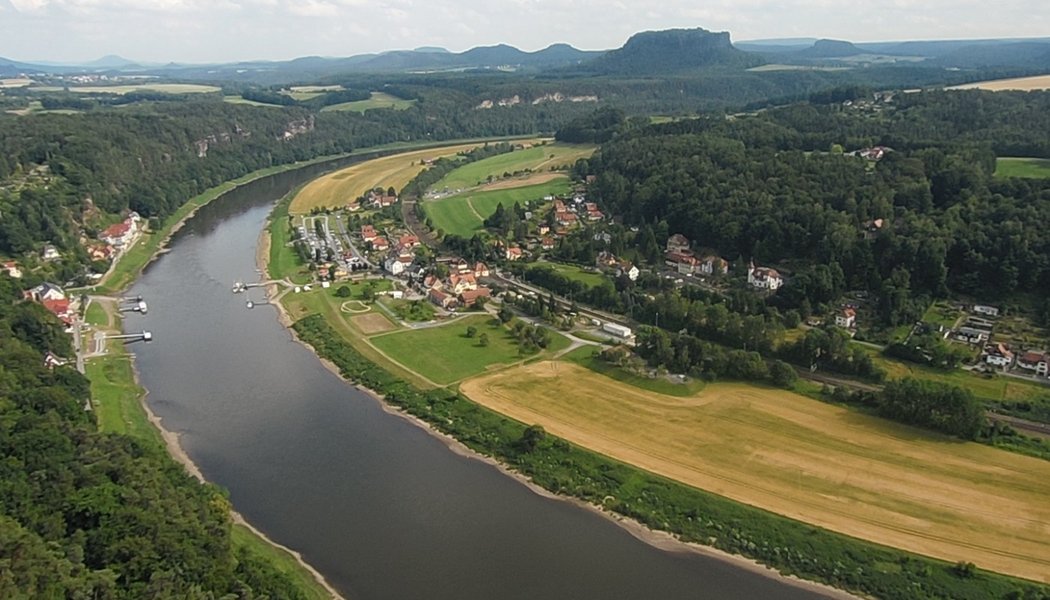
An example of a complex river system, showcasing the features that classification helps to understand and manage.
Frequently Asked Questions (FAQ)
Recommended Further Exploration
- What are the specific characteristics and management implications of each Rosgen stream type?
- How might climate change affect the flow regimes and morphologies of perennial versus ephemeral rivers?
- In what ways does riparian vegetation influence channel stability and how is this considered in fluvial classifications?
- What are the latest remote sensing and GIS techniques being used to map and classify river geomorphology on a large scale?
References
Last updated May 7, 2025