
Charting the Course: A Deep Dive into the History of Navigation
From Ancient Wayfinding to Modern GPS: Unraveling Humanity's Quest to Explore the World
Key Navigational Insights
- Polynesian Wayfinding: Ancient Polynesians mastered non-instrument navigation, utilizing profound knowledge of natural cues like stars, sun, ocean swells, and wildlife to traverse vast stretches of the Pacific Ocean for thousands of years.
- Evolution of Tools and Techniques: Navigation has transformed from rudimentary observations and tools like the quadrant and astrolabe to sophisticated modern systems such as GPS, radar, and digital charts, greatly enhancing accuracy and safety.
- Enduring Relevance of Traditional Skills: Despite technological advancements, traditional navigation skills remain crucial for safety, survival, and a deeper connection to the natural world, with some modern training still emphasizing these foundational methods.
Navigation, fundamentally, is the art and science of determining one's position and guiding movement from one place to another. This human endeavor has evolved dramatically over millennia, driven by an innate desire to explore, trade, and connect distant lands. From the earliest mariners who relied on keen observation of their environment to the sophisticated satellite systems of today, the history of navigation is a testament to human ingenuity and adaptability.
Recommended Books on the History of Navigation
For those seeking a comprehensive understanding of navigation's rich history, several excellent books stand out. While personal preference often dictates the "best" book, titles that provide a broad historical scope, delve into both traditional and modern techniques, and perhaps offer compelling narratives are highly recommended.
A Curated Selection for Navigation Enthusiasts
Based on various recommendations and content scope, here are some top contenders that cover the breadth of navigation history:
- "The History of Navigation" by Dag Pike: This book is frequently cited for its comprehensive overview of marine navigation, covering celestial, electronic, terrestrial, and satellite methods. Pike, a professional mariner, weaves in personal experiences, making the technical aspects more accessible and engaging. It provides a fascinating course through the successes and failures of mankind’s quest to explore the world.
- "Longitude: The True Story of a Lone Genius Who Solved the Greatest Scientific Problem of His Time" by Dava Sobel: While more focused on a specific period and challenge (the accurate determination of longitude at sea), this book is a captivating read that highlights a pivotal moment in navigation history. It underscores the immense difficulties faced by early mariners and the ingenuity required to overcome them.
- "Time and Navigation: The Untold Story of Getting from Here to There" by Carlene E. Stephens and Paul E. Ceruzzi: This companion book to a National Air and Space Museum exhibition explores the surprising connection between time and place in navigation. It traces developments from marine to air and space navigation, showcasing the continuous innovation in this field.
- "The American Practical Navigator" by Nathaniel Bowditch: Often referred to as "Bowditch," this is a classic and foundational text in maritime navigation. While not strictly a historical narrative, its historical editions offer immense insight into the practices and knowledge of past navigators. It's an encyclopedic resource for anyone serious about the subject.
These books collectively offer a rich tapestry of navigational history, from the earliest voyages to the complexities of modern technology, providing a well-rounded understanding of how humans have always striven to find their way.
Traditional Navigation Techniques: Mastering the Natural World
Before the advent of instruments, humans relied profoundly on their senses and deep understanding of the natural environment to navigate. This period, often called "wayfinding," demonstrates remarkable ingenuity and a profound connection to the world around them.
The Ingenuity of Polynesian Wayfinders
Perhaps one of the most celebrated examples of traditional navigation comes from the Polynesians. For thousands of years, these master mariners undertook extraordinary voyages across vast stretches of the Pacific Ocean, settling numerous islands without the aid of any modern instruments. Their techniques were incredibly sophisticated and relied on a holistic reading of nature.
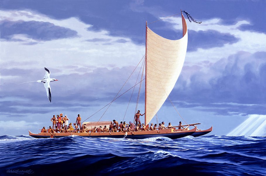
The Hōkūleʻa, a modern replica of an ancient Polynesian voyaging canoe, demonstrates the enduring legacy of traditional wayfinding.
Polynesian navigators used a "star compass," a mental construct rather than a physical tool, to orient themselves. This system involved memorizing the rising and setting points of numerous stars, providing a comprehensive directional guide throughout the night. They also observed the sun's position at different times of the day and its rising and setting points, which shifted with the seasons, offering crucial directional cues.
Beyond celestial bodies, Polynesian wayfinders were adept at interpreting subtle ocean swells and wave patterns. They understood that waves could refract around islands, creating unique interference patterns that indicated the presence and direction of land, even when it was out of sight. They also paid close attention to wind patterns, cloud formations (especially those indicating land), and the behavior of seabirds, which often signaled the proximity of islands. The knowledge was often passed down orally through generations, often in the form of intricate narratives describing voyages.
This video offers an insightful look into how Polynesian wayfinders navigated the Pacific Ocean, highlighting their deep connection to natural cues and the revival of these ancient techniques.
Early European and Other Traditional Methods
While Polynesian navigation is often highlighted for its non-instrumental nature, other early navigators across the globe also developed sophisticated techniques. Early European mariners, for instance, initially relied on coastal piloting, staying within sight of land and using prominent landmarks. As voyages extended into open waters, they began to use tools to measure celestial bodies:
- The Astrolabe: Descended from complex Arabian instruments, the astrolabe was suspended to hang perpendicular to sea level, allowing navigators to sight the sun or a star through small holes and measure its angle above the horizon.
- The Quadrant: Similar to the astrolabe but measuring only 90 degrees, the quadrant was a heavy metal plate with a plumb-bob. Navigators sighted along its edge to the sun or North Star, using the plumb-bob to mark the angle.
- The Cross-Staff: This tool, developed in the Middle Ages, consisted of a long staff with a sliding crosspiece used to measure the angle between the horizon and a celestial body.
- Magnetic Compass: Europeans understood the magnetic properties of lodestone for centuries. Early versions involved floating a magnetized needle on wood in water, eventually evolving into the pivoted needle common in modern compasses.
A display of historical navigation instruments, such as an astrolabe, showcasing the tools used by early mariners to determine their position.
These instruments, combined with dead reckoning (estimating position based on a vessel's course and speed), allowed mariners to venture further from land, though determining longitude remained a significant challenge until the development of accurate chronometers in the 18th century.
The March Towards Modern Navigation: Technology's Embrace
The 20th century marked a profound transformation in navigation, driven by rapid technological advancements. The need for faster, more accurate, and more reliable positioning became paramount with the advent of air travel and the increasing complexity of global shipping.
Electronic Revolution: From Radio to Radar
The early 20th century saw the introduction of radio communication, which quickly found navigational applications. Radio direction finders (RDF) allowed ships and aircraft to determine their bearing relative to known radio beacons, essentially radio versions of lighthouses. This provided an all-weather, all-time capability that celestial navigation could not.
Radar (Radio Detection and Ranging) further revolutionized navigation, particularly in marine and aeronautical contexts. By emitting radio waves and detecting their reflections, radar systems could display the presence, range, and bearing of other ships, buoys, islands, and coastlines, regardless of visibility. This dramatically improved safety, especially in fog or at night.

A modern ship's bridge featuring electronic navigation equipment, including a radar display and a digital chart system, illustrating the technological advancements in marine navigation.
The Age of Satellites: GPS and Beyond
The most significant leap in modern navigation arrived with satellite technology. The Global Positioning System (GPS), initially developed by the U.S. military, uses signals from a constellation of satellites orbiting Earth to provide precise position, velocity, and time information to a receiver anywhere on the globe. GPS offers unparalleled accuracy and convenience, fundamentally changing how humans navigate on land, sea, and air.
GPS has largely replaced older electronic systems like LORAN (Long Range Navigation) due to its superior accuracy and global coverage. Today, integrated bridge systems on ships combine GPS data with radar, digital charts, and other sensors to provide a comprehensive navigational picture. The navigator's role has evolved into that of a system manager, interpreting outputs and monitoring vessel response.
Beyond GPS, other Global Navigation Satellite Systems (GNSS) exist, such as Russia's GLONASS, Europe's Galileo, and China's BeiDou, providing redundancy and increased accuracy. Regional systems like India's IRNSS and Japan's QZSS further augment these capabilities.
Traditional vs. Modern Navigation: A Comparative Perspective
The evolution from traditional reliance on nature and basic instruments to sophisticated satellite technology represents a fundamental shift in navigation. While modern systems offer speed, precision, and convenience, traditional methods still hold significant value.
The radar chart below visually compares key attributes of traditional and modern navigation techniques. This analysis considers various factors such as accuracy, reliability, skill dependency, and environmental impact.
The radar chart illustrates the trade-offs between traditional and modern navigation. While modern techniques excel in accuracy and speed, traditional methods foster greater environmental awareness and reduce reliance on fragile technology. The "Reliability (Instrument Dependence)" axis indicates the vulnerability to instrument failure; traditional methods are more reliable in this aspect as they depend on natural cues, while modern methods are less reliable if technology fails. Similarly, "Skill Dependency" reflects the level of human expertise required; traditional navigation demands high skill, whereas modern navigation can be less demanding.
Modern navigation, with GPS at its core, offers unparalleled precision and speed, providing instant position fixes in virtually all weather conditions. However, this reliance on technology introduces vulnerabilities, such as signal loss, system malfunction, or cyber threats. Traditional methods, though slower and less precise, offer a robust failsafe. Many military training programs and maritime educational systems still emphasize traditional map reading, compass use, and celestial navigation as essential backup skills, ensuring navigators possess diverse capabilities.
Furthermore, traditional navigation fosters a deeper connection to the natural world. It requires a keen observational eye, an understanding of environmental patterns, and a heightened awareness of one's surroundings. This engagement can enhance physical and mental well-being, a stark contrast to the often screen-centric experience of modern navigation. The table below summarizes some key comparisons:
| Feature | Traditional Navigation | Modern Navigation (GPS/Electronic) |
|---|---|---|
| Primary Tools | Stars, Sun, Swells, Winds, Birds, Landmarks, Astrolabe, Quadrant, Compass | GPS receivers, Radar, Sonar, Digital Charts, ECDIS |
| Accuracy | Good for general direction/landfall, less precise for exact coordinates | High precision (within meters or less) |
| Speed of Position Fix | Slow, requires observation and calculation | Instantaneous |
| Weather Dependence | Requires clear skies for celestial navigation; sensitive to conditions affecting visibility of natural cues | Less dependent on weather; works in most conditions |
| Skill Set Required | Extensive knowledge of celestial bodies, oceanography, meteorology, keen observational skills | Understanding of electronic systems, software interfaces, data interpretation |
| Vulnerabilities | Limited by weather, human error in observation/calculation | Signal loss, electronic failure, cyber threats, battery dependence |
| Environmental Connection | High; deep interaction with natural elements | Lower; reliance on technological interfaces |
This table provides a concise comparison of key attributes between traditional and modern navigation methods, highlighting their respective strengths and weaknesses.
The Enduring Legacy and Future of Navigation
The history of navigation is a continuous narrative of human ingenuity and our relentless pursuit of understanding our place in the world. From the ancient voyagers who charted courses by the stars and waves to the satellite-guided vessels of today, the fundamental goal remains the same: to get from here to there safely and efficiently.
While modern technology offers unprecedented capabilities, the knowledge and appreciation of traditional navigation techniques are far from obsolete. They provide a vital backup, a deeper connection to the natural world, and a profound respect for the pioneering spirit of early explorers. As navigation continues to evolve, the integration of traditional wisdom with cutting-edge technology will likely define its future, ensuring both resilience and continued progress.
Frequently Asked Questions
Recommended Further Reading
- Explore the history of celestial navigation and its instruments.
- Understand the impact of GPS on modern maritime practices.
- Learn more about Polynesian voyaging traditions and their modern revival.
- Delve into a comparison of dead reckoning and electronic navigation.
References
 amazon.com
Last updated May 21, 2025