
Sketch Map of Lower Egypt Industrial Area
Visualizing Industrial Hubs Across the Nile Delta and Beyond
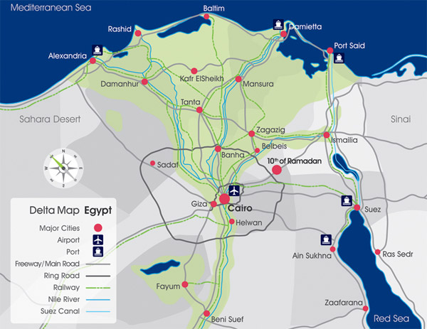
Key Highlights
- Geographical Layout: The map encompasses the Nile Delta, key cities, and coastal areas.
- Primary Industrial Zones: Highlights major industrial hubs in Cairo, Alexandria, and other strategic cities.
- Infrastructure Connections: Emphasizes the importance of transportation links and ports for trade and economic growth.
Understanding the Lower Egypt Industrial Area
Lower Egypt primarily refers to the northern portion of the country, notably the Nile Delta region, along with the Mediterranean coast. This area is not only known for its rich, fertile agricultural land but also for its rapidly expanding industrial landscapes. The industrial zones here have been strategically developed to leverage the advantages of proximity to major cities and ports, easy access to transportation networks, and the fertile environment which continues to support diverse economic activities.
The government of Egypt has initiated several measures to promote industrialization across the region. These include the establishment of numerous industrial zones and free zones, alongside targeted investment projects aimed at diversifying Egypt's economy. The development plan spans various governorates with a significant concentration in and around urban centers like Cairo and Alexandria, which act as the primary nodes in this industrial network.
Components of the Sketch Map
When designing a sketch map for the industrial areas in Lower Egypt, it is essential to incorporate multiple key components that highlight both natural and human-made features. Below is an outline of the main elements to consider:
1. Regional Boundaries and Natural Features
A clear boundary of the Nile Delta should be drawn, marking where the fertile lands begin and extend toward the Mediterranean Sea. Include the following:
a. Nile River and Its Branches
Depict the course of the Nile River and its major branches as they weave through the Delta. The river is the lifeline of the region, facilitating both agriculture and industry by providing essential water resources.
b. Mediterranean Coast
Outline the Mediterranean coastline, which serves as the gateway for international trade. Key ports along this coast, including Alexandria and Port Said, should be clearly indicated.
2. Urban Centers and Major Industrial Hubs
Pinpoint the major cities that drive industrial activity in Lower Egypt:
a. Cairo
Although Cairo is often regarded as the heart of Egypt’s economic activity, its influence extends to its surrounding industrial areas. For instance, the 15th of May City Industrial Zone is an important center for manufacturing and production.
b. Alexandria
Alexandria features prominently on the sketch map. One of the most notable zones here is the Borg El Arab Industrial Zone, which is among the largest and houses diversified sectors such as textiles and electronics.
c. Other Notable Cities
Besides Cairo and Alexandria, cities like Port Said, Ismailia, and Damietta are integral to the industrial landscape. They host various sectors ranging from petrochemicals to food processing, and their roles are emphasized in the map.
3. Industrial Zones and Sector Diversification
The focus of the map is to exhibit marked areas where industrial activities are concentrated. In Lower Egypt, many zones have been designated for specific industrial activities, including:
a. Manufacturing and Textiles
Several industrial zones have specialized in manufacturing goods, with textiles being a significant output due to the existing skilled workforce and established supply chains.
b. Food Processing
Food processing units are common, taking advantage of both the fertile lands and the efficient logistics provided by nearby ports, ensuring rapid movement of processed goods locally and internationally.
c. Petrochemicals and Heavy Industries
Some zones are dedicated to heavier industries, including petrochemicals and construction materials. These areas are strategically placed adjacent to transportation networks for export and logistics purposes.
4. Infrastructure and Connectivity
A critical aspect of the sketch map is to display the inter-connectivity of these industrial regions:
a. Transportation Networks
Major highways, rail links, and inland waterways should be included to highlight how industries link to key markets. These routes are crucial for the efficient transportation of raw materials and finished goods.
b. Proximity to Ports
The strategic advantage of being near ports such as Alexandria and Port Said is underlined through visual markers. Ports are significant not only for export activities but also for attracting foreign investments.
Illustrative Table: Industrial Zones in Lower Egypt
The table below highlights some of the major industrial zones, their locations, and predominant sectors:
| Industrial Zone | Location | Key Sectors | Significance |
|---|---|---|---|
| 15th of May City Industrial Zone | Cairo | Manufacturing, Textiles, Food Processing | Major hub for industrial activities in the capital region |
| Borg El Arab Industrial Zone | Alexandria | Textiles, Electronics, Food Processing | One of the largest industrial areas leveraging coastal trade |
| Port Said Industrial Zone | Port Said | Shipping, Logistics, Petrochemicals | Supports maritime and export-oriented industries |
| Ismailia Industrial Zone | Ismailia | Textiles, Light Engineering | Connects the north and south markets with agile supply chains |
| Damietta Industrial Area | Damietta | Food Processing, Furniture, Maritime Equipment | Utilizes local resources with access to maritime logistics |
Designing the Sketch Map: Step-by-Step Guide
Here is a detailed guide to conceptualize and draw your sketch map, keeping in mind the comprehensive aspects discussed above:
Step 1: Define Your Base Map
Begin with a basic outline of Lower Egypt that includes the Nile Delta region and the coastal boundary along the Mediterranean. You can obtain a simple geographical template from authoritative sources or open-source mapping tools.
Step 2: Mark Key Cities and Urban Centers
Identify and mark major cities such as Cairo, Alexandria, Port Said, Ismailia, and Damietta. Each of these urban centers serves as a nucleus for regional economic activity. Consider using distinct symbols or colored markers for clarity.
Step 3: Delineate Industrial Zones
Overlay the industrial zones within these cities. Each zone should be clearly labeled with its name and the dominant industrial sectors. Utilize shading or color differentiation to indicate various industries—for example, use one color for manufacturing hubs and another for food processing areas.
Step 4: Include Infrastructure Elements
Connect the industrial zones by drawing roads, rail lines, and highlighting access points such as ports. Make sure to indicate the Nile River and its branches since these water routes play a critical role in regional logistics.
Step 5: Add Annotations and Legend
Create a legend that explains the symbols, colors, and notations used on the map. Annotations can provide additional insights such as investment zones, historical development periods, or future project locations. This makes your sketch map an informative tool for understanding the economic landscape.
For those who might need to develop a digital version of this map, there are multiple software tools available such as GIS software, Adobe Illustrator, or even online mapping services that allow the layering of various data points. Ensure to cite any specific data sources used.
Industrial Development Context in Lower Egypt
Industrial growth in Lower Egypt is part of a broader strategy to boost the national economy by diversifying investment opportunities and creating a strong industrial infrastructure. The government has facilitated the development of special economic zones and implemented initiatives that support both local and foreign investors.
Investments in industrial zones have generated significant employment opportunities and have not only spurred economic development locally but have also had a ripple effect on Egypt's overall GDP. With plans to expand and modernize these zones further, Lower Egypt is emerging as a pivotal area for industries ranging from light manufacturing to heavy industries.
Resources for Further Exploration
For readers interested in exploring more about the industrial maps and investment opportunities in Lower Egypt, consider referring to the following authoritative sources. These resources provide detailed industrial investment maps and guides which can further enhance your understanding:
- Industrial Investment Map - Invest In Egypt
- Industrial Investment Plots - Egypt Investment Guide
- Government Plans for Industrial Zones - Enterprise News
- Your Guide to Industrial Investment in Egypt - ECES
- Lower Egypt Overview - Wikipedia
Recommended Searches for Deeper Insights
Last updated March 19, 2025