
Mapping the Menace: Understanding Landslide Hazard Zonation
A comprehensive guide to how experts classify land based on landslide potential to enhance safety and planning.
Landslide Hazard Zonation (LHZ) is a critical process for evaluating the potential danger posed by landslides across different geographical areas. It involves systematically dividing land into zones based on the varying degrees of actual or potential landslide hazard. This classification helps identify where landslides are more likely to occur, providing essential information for disaster risk reduction, land-use planning, infrastructure development, and emergency management.
Highlights
- Definition: Landslide Hazard Zonation (LHZ) systematically classifies terrain into zones (e.g., low, moderate, high) based on the likelihood of landslide occurrence, considering various causative factors.
- Methodologies: LHZ employs diverse methods, ranging from expert-driven qualitative approaches (heuristic, geomorphic) to data-intensive quantitative techniques (statistical, deterministic, probabilistic), often integrated with Remote Sensing and GIS.
- Importance: LHZ maps are vital tools for informed decision-making in land-use planning, infrastructure siting, risk mitigation strategies, and emergency preparedness, ultimately aiming to reduce potential losses to life and property.
Why is Landslide Hazard Zonation Crucial?
Landslides pose significant threats, especially in hilly and mountainous regions. LHZ provides a proactive approach to managing these risks. By identifying areas prone to instability, authorities and planners can:
- Enhance Risk Mitigation: Prioritize areas needing stabilization measures (e.g., retaining walls, drainage improvements) or monitoring.
- Guide Land-Use Planning: Steer development away from high-hazard zones, designating safer areas for housing, critical infrastructure, and agriculture. Regulatory frameworks often use LHZ maps to enforce building codes and land use restrictions.
- Support Infrastructure Development: Ensure roads, bridges, pipelines, and other essential infrastructure are sited and designed considering potential landslide impacts.
- Improve Emergency Preparedness: Inform the development of early warning systems, evacuation plans, and resource allocation for disaster response.
- Promote Environmental Conservation: Identify vulnerable ecosystems that could be impacted by landslides or mitigation efforts.
Ultimately, effective LHZ contributes to community resilience and sustainable development by minimizing the devastating consequences of landslides.
Key Factors Influencing Landslides
LHZ relies on evaluating a combination of factors that prepare slopes for failure and trigger actual landslides. Understanding these factors is fundamental to accurate zonation:
Geological and Geomorphological Factors
The Ground Beneath Our Feet
The inherent characteristics of the ground itself play a major role. This includes:
- Lithology: The type of rock and soil present. Weak, fractured, or weathered rock materials are more susceptible to failure than strong, intact rock. Soil type and depth also influence stability.
- Geological Structures: Features like faults, folds, joints, and bedding planes can create zones of weakness within the rock mass, predisposing slopes to landslides.
- Geomorphology: The shape of the land surface, including slope angle (steepness), aspect (the direction a slope faces), curvature, and relative relief. Steeper slopes are generally more prone to failure.
Hydrological Factors
The Role of Water
Water is a critical triggering factor for many landslides. Key hydrological considerations include:
- Rainfall: Intense or prolonged rainfall saturates soil and rock, increasing pore water pressure (the pressure of water within the pores and fractures of the material), which reduces the shear strength of the slope material, making it easier for failure to occur.
- Drainage Patterns: The way water flows over and through the landscape. Concentrated surface runoff can erode slopes, while poor subsurface drainage can lead to saturation. Proximity to streams and rivers is often a factor.
- Groundwater Levels: Elevated groundwater levels, often responding to rainfall or snowmelt, increase pore water pressure and can lubricate potential failure surfaces.
Environmental and Anthropogenic Factors
Natural Cover and Human Impact
Both natural conditions and human activities modify slope stability:
- Land Use/Land Cover: Vegetation, particularly deep-rooted trees, helps stabilize slopes by binding soil and reducing water infiltration. Deforestation, agriculture on steep slopes, and urbanization can remove this protective cover and alter drainage, increasing landslide susceptibility.
- Anthropogenic Activities: Construction (especially road cuts and building excavations that undercut slopes), mining, improper slope modification, and irrigation can significantly destabilize slopes.
- Seismic Activity: Earthquakes can trigger widespread landslides by shaking the ground and reducing material strength.
Historical Landslide Data
Learning from the Past
Information about past landslides is invaluable. A landslide inventory map, documenting the location, type, size, and estimated date of previous events, is often a fundamental input for LHZ. Areas that have experienced landslides in the past are often susceptible to future events.
Methodologies for Landslide Hazard Zonation
No single method is universally applicable for LHZ; the choice often depends on the scale of the study, data availability, resources, and the specific objectives. Methods range from qualitative assessments to complex quantitative modeling:
Inventory-Based Mapping
This is often the first step, involving the systematic collection and mapping of existing and past landslide occurrences. This data is crucial for understanding landslide distribution patterns and serves as a basis for calibrating or validating other zonation methods.
Qualitative (Heuristic) Approaches
These methods rely heavily on expert knowledge and judgment to assess landslide potential based on the presence and significance of various causative factors. They are particularly useful when detailed quantitative data is scarce.
Geomorphic Techniques
These are direct methods focusing on mapping landforms and features indicative of slope instability (e.g., scarps, hummocky terrain). Experts interpret aerial photographs, satellite imagery, and conduct field surveys to identify areas prone to landslides based on their geomorphological characteristics.
Factor Weighting
Experts assign weights or scores to different causative factors (like slope, geology, land use) based on their perceived importance in causing landslides. These scores are then combined to create a relative hazard index (e.g., India's Bureau of Indian Standards' LHEF rating).
Quantitative Approaches
These methods use numerical data and mathematical models to assess landslide susceptibility and hazard.
Statistical Methods
Statistical techniques analyze the spatial relationship between past landslide occurrences and various causative factors.
- Bivariate Analysis: Compares the distribution of landslides with each individual factor map (e.g., slope categories, geology types). Examples include Frequency Ratio and Weights of Evidence.
- Multivariate Analysis: Considers the combined influence of multiple factors simultaneously. Examples include Logistic Regression.
Deterministic Methods
These methods apply principles of physics and engineering mechanics to calculate slope stability. They typically use Factor of Safety (FoS) calculations, which compare the forces resisting movement to the forces driving movement on a slope. These methods require detailed data on soil/rock strength parameters and groundwater conditions, often making them suitable for site-specific analysis or smaller areas.
Probabilistic Methods
Probabilistic methods go beyond susceptibility (where landslides might occur) to estimate the likelihood (probability) of landslide occurrence within a specific timeframe, considering the frequency of triggering events (like intense rainfall or earthquakes).
Multi-Criteria Decision Making (MCDM)
MCDM techniques provide a structured framework for combining multiple, often conflicting, criteria (causative factors) to derive a hazard or susceptibility index. Methods like the Analytical Hierarchy Process (AHP) allow experts to assign relative weights to factors based on pairwise comparisons. The Weighted Overlay technique, often implemented in GIS, combines different thematic layers (maps of factors) based on assigned weights or scores to produce a final hazard map.
The Role of Technology: Remote Sensing and GIS
Modern LHZ heavily relies on advancements in Remote Sensing (RS) and Geographic Information Systems (GIS). These technologies provide powerful tools for:
- Data Acquisition: Satellites and aerial platforms capture imagery used to derive crucial information like topography (from Digital Elevation Models - DEMs), land cover/use, and sometimes even detect ground deformation indicative of slope movement.
- Data Management: GIS provides a platform to store, manage, and organize vast amounts of spatial data (maps of geology, slope, rainfall, historical landslides, etc.).
- Spatial Analysis: GIS enables the core analysis for LHZ, allowing overlaying of different factor maps, performing statistical calculations, implementing models (like weighted overlay or deterministic stability analysis), and classifying areas into hazard zones.
- Visualization and Mapping: GIS is used to produce the final LHZ maps, clearly visualizing the different hazard zones for planners and the public.
RS provides the essential input data, while GIS acts as the analytical engine and visualization tool, making complex LHZ assessments more efficient and accurate.
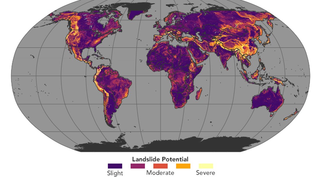
Global map showing areas with moderate to high landslide susceptibility based on factors like slope, geology, and rainfall (NASA Earth Observatory).
Visualizing Hazard Factor Importance
The relative importance of different factors contributing to landslide hazard can vary significantly depending on the region and local conditions. The radar chart below provides a hypothetical visualization of factor importance for a mountainous region known for high rainfall and moderate seismic activity. Factors are rated on a scale reflecting their potential contribution to landslide risk in this specific context.
In this example, slope steepness, rainfall, and underlying geology are considered highly influential, while factors like historical occurrences, vegetation loss, seismic potential, and human modifications also contribute significantly to the overall hazard level.
Mapping the LHZ Workflow
The process of creating Landslide Hazard Zonation maps typically follows a structured workflow, integrating data collection, analysis, and application. The mindmap below outlines the key stages involved in a comprehensive LHZ study.
(Location, Type, Date)"] id1b["Causative Factor Maps
(DEM, Geology, Soil, Land Use, Rainfall etc.)"] id1c["Base Maps
(Topographic, Administrative)"] id1d["Data Integration in GIS"] id2["2. Methodology Selection"] id2a["Qualitative / Heuristic"] id2b["Quantitative
(Statistical, Deterministic, Probabilistic)"] id2c["MCDM"] id2d["Hybrid Approaches"] id3["3. Analysis & Modeling"] id3a["Factor Weighting / Scoring"] id3b["Statistical Correlation / Regression"] id3c["Slope Stability Calculation (FoS)"] id3d["Probability Assessment"] id3e["Model Implementation (GIS)"] id4["4. Zonation & Map Production"] id4a["Classification of Hazard Levels
(Low, Moderate, High, Very High)"] id4b["Generation of LHZ Map"] id4c["Cartographic Representation"] id5["5. Validation & Refinement"] id5a["Comparison with Independent Data
(e.g., new landslide events)"] id5b["Field Checks"] id5c["Model Adjustment / Update"] id6["6. Application & Dissemination"] id6a["Land-Use Planning"] id6b["Infrastructure Siting"] id6c["Risk Mitigation Prioritization"] id6d["Emergency Management"] id6e["Public Awareness"] id6f["Policy & Regulation"]
This workflow highlights the iterative nature of LHZ, often involving validation and refinement steps to improve map accuracy and reliability before applying the results for practical decision-making.
Summary of Factors and Assessment Methods
Different causative factors require specific data sources and analysis techniques for assessment within an LHZ framework. The table below summarizes common factors and the methods or data typically used to evaluate their influence.
| Factor | Common Assessment Methods / Data Sources |
|---|---|
| Slope Steepness & Aspect | Digital Elevation Model (DEM) analysis in GIS, Topographic maps, Field surveys |
| Geology & Lithology | Geological maps, Field surveys, Borehole data, Remote sensing (spectral analysis) |
| Soil Type & Properties | Soil maps, Geotechnical testing (lab/field), Field surveys |
| Land Use & Land Cover | Satellite imagery classification (GIS), Aerial photo interpretation, Land use maps, Field surveys |
| Hydrology (Rainfall, Drainage) | Rain gauge data, Weather radar, DEM analysis (flow accumulation, drainage networks), Hydrological modeling |
| Groundwater Levels | Piezometer data, Hydrogeological studies, Field observations (springs, seeps) |
| Proximity to Faults/Lineaments | Geological maps, Remote sensing analysis (imagery interpretation), DEM analysis |
| Historical Landslides | Landslide inventory maps, Historical archives, Aerial photo/Satellite image interpretation, Field surveys |
| Vegetation Cover | Normalized Difference Vegetation Index (NDVI) from satellite imagery, Field surveys, Land cover maps |
| Anthropogenic Activity | Infrastructure maps (roads, buildings), Land use planning documents, Field observation, Analysis of cut/fill slopes from DEMs |
| Seismic Activity | Earthquake catalogues, Seismic hazard maps (Peak Ground Acceleration), Fault maps |
Visual Tutorial: Weighted Overlay in GIS
The Weighted Overlay method is a common technique used in GIS for landslide susceptibility and hazard zonation, falling under the umbrella of Multi-Criteria Decision Making (MCDM). It involves combining several factor maps (like slope, geology, land use) that influence landslide occurrence. Each factor map is first reclassified or ranked based on its contribution to landslide susceptibility (e.g., steeper slopes get higher susceptibility scores). Then, each ranked factor map is assigned a weight reflecting its overall importance relative to other factors. Finally, the GIS software multiplies each ranked map by its weight and sums them all up to produce a final susceptibility or hazard map.
The following video provides a tutorial on how to perform landslide hazard mapping using the weighted overlay method within the ArcGIS software environment, demonstrating the practical steps involved in implementing this widely used LHZ technique.
Outputs and Applications of LHZ
The primary output of the LHZ process is a map delineating zones of varying landslide hazard potential.
Landslide Hazard Maps
These maps typically categorize the landscape into several zones, often using qualitative terms like:
- Low Hazard Zone: Landslides are unlikely under normal conditions.
- Moderate Hazard Zone: Landslides may occur, often triggered by significant events (heavy rainfall, earthquakes). Some precautions may be necessary.
- High Hazard Zone: Landslides are likely to occur. Development is generally discouraged or requires significant engineering intervention and mitigation.
- Very High Hazard Zone: Landslides are highly likely or frequent. These areas are typically unsuitable for most types of development.
Some maps may provide more quantitative information, such as the probability of landslide occurrence within a given timeframe.
Applications in Planning and Mitigation
LHZ maps are invaluable decision-support tools:
- Land-Use Planning: Guiding zoning regulations, restricting development in high-risk areas, and identifying safer locations for settlements and agriculture.
- Infrastructure Development: Informing the routing and design of roads, railways, pipelines, and locating critical facilities like hospitals and schools away from hazardous zones.
- Mitigation Strategy Prioritization: Helping authorities allocate limited resources effectively by focusing stabilization efforts (e.g., terracing, retaining walls, drainage control, reforestation) on the most hazardous areas posing the greatest risk.
- Building Codes: Informing specific design and construction standards for buildings in moderate hazard zones.
- Emergency Management: Assisting in the design of evacuation routes, placement of shelters, development of early warning systems, and public awareness campaigns about landslide risks.
- Regulatory Frameworks: Forming the basis for official guidelines and regulations governing development in landslide-prone areas (e.g., Washington Administrative Code WAC 222-16-050, Bureau of Indian Standards IS 14496).
Challenges in Landslide Hazard Zonation
Despite its importance, LHZ faces several challenges:
- Data Availability and Quality: Accurate zonation requires comprehensive and reliable data on geology, topography, hydrology, land use, and historical landslides, which can be scarce or inconsistent, especially in remote or developing regions.
- Methodological Complexity: Choosing the most appropriate method requires expertise, and different methods can yield varying results for the same area. There is no single universally accepted "best" method.
- Dynamic Conditions: Landslide hazards are not static. Climate change (altering rainfall patterns), seismic activity, and ongoing human activities (like construction or deforestation) can change hazard levels over time, requiring periodic updates of LHZ maps.
- Scale Issues: Methods suitable for regional assessment may lack the detail needed for site-specific planning, and vice-versa.
- Validation Difficulties: Rigorously validating the predictive accuracy of LHZ maps can be challenging, often requiring long-term monitoring or comparison with future landslide events.
Frequently Asked Questions
Recommended
- What are the most effective landslide mitigation techniques?
- How does climate change impact landslide frequency and hazard?
- Explore case studies of successful landslide hazard management using LHZ.
- What role does community participation play in landslide risk reduction?
References
Last updated May 5, 2025