
Unveiling the Best Location Documentation Apps for Your Mobile Device
Explore top-tier mobile applications designed to accurately record and organize your movements, perfect for travel, personal history, or family safety.
Mobile applications for documenting location have become indispensable tools in our increasingly connected world. Whether you're a globetrotter eager to map every country visited, a parent ensuring your child's safety, or simply someone who wants a digital journal of their daily whereabouts, these apps leverage sophisticated technologies like GPS, Wi-Fi, and cellular data to provide precise and comprehensive location tracking. This guide delves into the diverse landscape of location documentation apps, highlighting their features, use cases, and how they empower users to keep a meticulous record of their movements.
Key Highlights of Location Documentation Apps
- Versatile Functionality: Modern location apps serve a multitude of purposes, from simple trip logging and travel mapping to advanced family safety and professional tracking.
- Advanced Location Technologies: Apps utilize a combination of GPS, Wi-Fi, and cellular network data, and even inertial sensors, to ensure high accuracy in diverse environments, both indoors and outdoors.
- Privacy and Control: While offering powerful tracking capabilities, many leading apps prioritize user privacy, providing options to control data sharing, delete history, and maintain discretion.
Understanding Location Tracking Technologies
At the heart of any location documentation app lies its ability to accurately pinpoint a device's geographical position. This precision is achieved through a combination of sophisticated technologies:
Global Positioning System (GPS)
GPS is the cornerstone of outdoor location tracking. It relies on a network of satellites orbiting Earth that transmit signals. A GPS receiver in your mobile device picks up these signals from multiple satellites and triangulates its position based on the time difference of arrival of these signals. This method offers high accuracy, especially in open areas with a clear view of the sky. Modern smartphones use assisted GPS (A-GPS) which combines satellite data with cellular network information for faster and more accurate fixes, even in challenging environments like urban canyons.
Wi-Fi Positioning System (WPS)
When GPS signals are weak or unavailable, particularly indoors, Wi-Fi Positioning System (WPS) comes into play. WPS determines a device's location by identifying nearby Wi-Fi networks and comparing their signal strengths to a database of known Wi-Fi access point locations. This method is surprisingly accurate in urban areas dense with Wi-Fi hotspots and is crucial for indoor navigation and location services.
Cellular Network Positioning
Also known as cellular ID or cell tower triangulation, this method uses the signals from nearby cellular base stations to estimate a device's location. While generally less precise than GPS or Wi-Fi positioning, it serves as a reliable fallback, especially in areas with limited Wi-Fi coverage or when GPS signals are completely absent. The unique identifier of each cell tower provides an approximate location.
Inertial Sensors and Other Technologies
Modern smartphones are equipped with a suite of inertial sensors, including accelerometers, gyroscopes, and magnetometers. These sensors can track movement and orientation, providing valuable contextual data that can improve location accuracy and even predict movement patterns when combined with other positioning methods. Additionally, technologies like Bluetooth (especially for beacons) and Ultra-Wideband (UWB) are used for highly precise indoor tracking, offering accuracy within a few centimeters for applications like item trackers.
Top Mobile Apps for Documenting Your Location
The market for location documentation apps is rich with options, each catering to slightly different needs. Here's a breakdown of some of the most prominent and highly-rated choices:
For Travel Enthusiasts and Adventurers
Travelers often seek apps that can not only track their routes but also help them visualize their journey, mark visited places, and share their experiences.
Google Maps Timeline
Google Maps is arguably the most ubiquitous mapping service, and its "Timeline" feature is a powerful, passive location logger. If you have Location History enabled, Google Maps automatically records your routes, places you've visited, and even modes of transport. You can view your history by day, month, or year, and it can help you remember exact businesses and foreign countries you've been to. It’s integrated with your Google Account, providing a comprehensive personal map of your movements.
Google Maps Interface for Location Tracking
Polarsteps
Polarsteps is an all-in-one travel app that automatically plots your route, locations, and photos on a beautiful world map. It’s designed for travelers who want to track their journey, add photos and descriptions, and share their adventures with friends and family. It can also suggest enticing travel destinations and offer insider tips, making it a comprehensive travel companion.
Visited
Visited allows you to design your personal travel map, consisting of countries, states, regions, and cities you have been to, lived in, or want to visit. It’s a travel tracker app that lets you map your travels and discover new destinations based on your interests, helping you decide "where to next." It values user privacy by not tracking your location continuously unless specifically enabled for certain features.
TrackMyTour
TrackMyTour enables users to create an online travel map and journal for friends and family to follow along. You can add waypoints and highlight locations, making it an excellent tool for sharing live updates of your journey with loved ones.
For Personal Safety and Family Monitoring
Many apps are specifically designed to provide peace of mind by allowing real-time location sharing and safety features for family members and close friends.
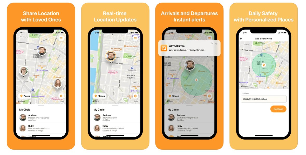
Life360
Life360 is a leading family location safety app. It offers real-time location sharing, crash detection, smart notifications, location history, place alerts (geofencing), and SOS help alerts. It goes beyond simple GPS tracking, integrating with Tile Bluetooth trackers to help keep tabs on essential items like keys, wallets, and even pets. It's particularly useful for families to monitor each other's whereabouts and ensure safety, even providing insights into driving habits like speed and phone usage.
Life360 App Interface for Family Tracking
iSharing
iSharing provides a real-time locator service, allowing family members and close friends to privately share their locations. It also impresses with its ability to track location history, showing detailed routes taken, which can be helpful for various situations, including keeping an eye on children or locating lost devices. It supports both Android and Apple devices.
FamiSafe
Wondershare FamiSafe is a top-rated parental control app that offers real-time location updates and detailed location history for both Android and iPhone devices. Its geofencing feature allows parents to set safe zones and receive instant alerts when children enter or leave these areas. It's considered one of the best family locator apps for parents who want to keep tabs on their kids' whereabouts with high accuracy.
For Detailed Logging and Data Export
Some users require more granular control over their location data, often for professional use, fitness tracking, or in-depth analysis.
Geo Tracker - GPS tracker
This app allows you to record GPS tracks of your trips, analyze statistics, and share them. It's ideal for those who need a robust tool for logging specific routes and reviewing performance metrics, whether for hiking, cycling, or other outdoor activities.
Location Log
Location Log is designed for individuals who want to know exactly where they were at any point in time while valuing their privacy. It continuously and accurately tracks your location in the background, optimizing battery usage. It offers a history function to view movements on any date, a distance calculator, and search functions, along with options to delete, import, and export data, giving users complete control over their information.
Fitness-Oriented Apps (Runkeeper, Strava, Endomondo)
While primarily focused on fitness, apps like Runkeeper, Strava, and Endomondo excel at recording GPS position during outdoor activities like running, cycling, and hiking. They track pace, calories burned, and other metrics, and importantly, allow users to export their GPS data (e.g., in GPX or CSV formats) for further analysis in other mapping software like Google Earth. This makes them excellent choices for documenting specific activity routes.
Choosing the Right Location Documentation App
Selecting the best app depends largely on your specific needs and priorities. Here's a radar chart comparing various aspects of popular location tracking app categories to help you make an informed decision.
Comparative Analysis of Location Tracking App Features
This radar chart illustrates a comparative assessment of different types of location tracking apps across key attributes. "Travel & Exploration" apps excel in visual trip documentation and sharing, while "Family Safety" apps prioritize real-time monitoring and alert features. "Data Logging & Analysis" apps stand out for their precision and export capabilities, and "General Utility" apps like Google Maps offer broad accessibility and integration. This visual representation helps to highlight where each category of app typically shines, guiding you towards an app that aligns best with your specific requirements for location documentation.
Feature Comparison for Location Documentation Apps
To further assist in your decision, here's a detailed comparison of key features across different categories of location documentation apps:
| Feature | Travel & Exploration Apps (e.g., Polarsteps, Visited) | Family Safety Apps (e.g., Life360, FamiSafe) | Data Logging & Analysis Apps (e.g., Geo Tracker, Location Log) | General Utility (e.g., Google Maps Timeline) |
|---|---|---|---|---|
| Real-time Tracking | Moderate (often for specific segments, not continuous) | High (continuous, highly accurate updates) | High (continuous background logging) | High (if Location History is enabled) |
| Location History | Detailed historical maps with photos and journal entries | Extensive history, often with driving reports and routes | Precise chronological log with timestamps and coordinates | Comprehensive timeline of places and routes visited |
| Geofencing/Place Alerts | Limited or none (focus on discovery) | High (alerts for entering/leaving defined zones) | None | Available through custom "Places" |
| Privacy Controls | Generally strong, with user control over data sharing | Varies, but often allows sharing within designated "circles" | High (data often stored locally or with clear export options) | User-managed settings for Location History and Web & App Activity |
| Data Export Options | Some (e.g., trip summaries, photo albums) | Limited (primarily for in-app viewing) | High (e.g., GPX, KML, CSV for detailed analysis) | Limited direct export (can view on Timeline) |
| Visual Mapping | Highly visual, custom travel maps, photo integration | Clear map display with family members' icons | Basic map view of recorded tracks | Detailed map with satellite, terrain, and street views |
| Battery Usage | Moderate (optimized for intermittent tracking) | Can be high (due to continuous real-time updates) | Optimized for background use, but can be moderate to high | Moderate to high (depending on usage and settings) |
| Sharing Features | Strong (public/private trip sharing, social media integration) | Within trusted "circles" or family groups | Limited (often manual export for sharing) | Live location sharing, shared lists |
Considerations for Using Location Tracking Apps
While highly beneficial, using location documentation apps comes with important considerations:
Battery Consumption
Continuous GPS tracking can significantly drain your device's battery. Apps often employ optimization techniques, but it's wise to carry a portable charger, especially during long trips or if you rely on real-time tracking.
Privacy Concerns
Sharing your location data, even with trusted individuals or within an app, raises privacy implications. Always review an app's privacy policy, understand what data is collected and how it's used, and utilize available controls to manage your sharing preferences. Some apps, like Visited, explicitly state they do not track your location unless features requiring it are actively used, which can be a strong selling point for privacy-conscious users.
Accuracy in Diverse Environments
Location accuracy can vary depending on your environment. Dense urban areas with tall buildings (urban canyons) or indoor spaces can degrade GPS signals, leading to less precise location data. Apps compensate by integrating Wi-Fi and cellular positioning, but complete accuracy in all scenarios is challenging.
Internet Connectivity
Many advanced features, especially those involving map loading, sharing, and cloud backups, require an active internet connection. Some apps offer offline map capabilities or store data locally, but real-time tracking and sharing will always rely on connectivity.
Embracing the Journey: The Power of Location Tracking
Location tracking apps, whether for personal memory-keeping or family safety, offer unparalleled convenience and peace of mind. They transform your mobile device into a powerful logging tool, capturing the essence of your journeys and daily life. As these technologies continue to evolve, they promise even more intuitive and integrated ways to document and interact with the world around us.
A Comparison of Popular Location Tracking Apps: Google Maps, Find My Friends, and Life360. This video highlights the key features and differences between these widely used platforms, providing a comprehensive overview for users seeking to understand their capabilities for family tracking and personal safety.
Frequently Asked Questions
Conclusion
The array of mobile applications available for documenting your location offers unparalleled opportunities to log your travels, ensure the safety of loved ones, or simply keep a personal record of your movements. From the comprehensive timelines of Google Maps to the adventure-focused maps of Polarsteps and the robust safety features of Life360, there's an app tailored for every need. By understanding the underlying technologies and carefully considering features like privacy controls, battery usage, and data export options, you can select the perfect tool to capture your journey through the world.
Recommended Searches
- Discover the best travel journal apps that integrate maps and photo logging.
- Learn how to safely track your family's location using mobile apps with privacy features.
- Find top-rated apps for recording and analyzing GPS data from hiking and outdoor activities.
- A deep dive into the privacy features and data handling of popular location tracking applications.
Referenced Search Results
 docs.aws.amazon.com