
Discover the Ideal Sensor for Pothole Detection
Choosing the Right Sensor Technology to Enhance Road Maintenance Efficiency
Key Insights
- Integration of Multiple Sensing Modalities: A combination of camera-based computer vision systems, LiDAR, and vibrational sensors maximizes detection accuracy.
- Real-Time and Detailed Monitoring: Advanced sensors not only detect potholes immediately but also capture detailed visual and 3D data to facilitate maintenance decisions.
- Cost-Effectiveness vs. Precision Trade-offs: While high-end sensors offer superior detail, lower-cost alternatives can be deployed effectively in large-scale, community-centric applications.
Overview of Sensor Technologies
Local governments require robust and effective technologies for road maintenance to ensure smooth transport and enhance safety. Among common sensor technologies available, three leading candidates often emerge: camera-based computer vision systems, LiDAR sensors, and vibration sensors that include accelerometers (potentially with gyroscopes). These technologies can be deployed independently or in a hybrid configuration to capitalize on the strengths of each method.
Camera-Based Computer Vision Systems
Technology and Implementation
Computer vision systems rely on high-resolution cameras mounted on maintenance vehicles. These cameras capture continuous images of the road surface. By applying machine learning algorithms such as convolutional neural networks (CNNs) or object detection models like YOLO (You Only Look Once), the system can identify potholes in real-time. This approach has several benefits:
- Instantaneous Identification: Integrated with real-time processing units, camera systems can detect and categorize potholes effectively as the vehicle is in motion.
- Visual Documentation: The captured images serve as evidence for road conditions, assisting in planning maintenance schedules and validating repair work.
- Adaptability: They can be enhanced with weather-adaptive algorithms to maintain accuracy regardless of lighting or weather conditions.
Despite their strengths, computer vision systems require substantial computational power, possibly necessitating onboard processing units or cloud connectivity for real-time inference, especially in harsh environmental conditions.
LiDAR Sensors for 3D Road Mapping
Functionality and Benefits
LiDAR (Light Detection and Ranging) sensors transmit laser pulses to measure distances with high precision, creating detailed three-dimensional maps of the road surface. This technique is exceptionally useful for detecting minute road imperfections such as small potholes, cracks, and gradual depressions. Key advantages include:
- High Precision: LiDAR provides sub-centimeter resolution data, ensuring even tiny road irregularities are identified.
- 3D Reconstruction: By generating detailed 3D representations, maintenance teams can assess the depth, width, and spread of each pothole, which helps in accurate repair planning.
- Robust Under Varied Conditions: In contrast to optical sensors, LiDAR is less affected by changes in lighting conditions, making it particularly useful at night and under overcast skies.
However, LiDAR sensors tend to be more expensive, and additional computing resources are required to process the large amount of data generated. This technology often pairs well with camera systems to form a complementary analysis framework.
Vibration Sensors and Accelerometers
Mechanism and Integration
Vibration sensors, such as accelerometers and gyroscopes, monitor the dynamics of vehicles as they traverse roads. When the vehicle encounters a pothole, the sudden jolt causes an identifiable vibration pattern. These sensors are noteworthy for the following reasons:
- Cost-Effectiveness: Accelerometers are generally low-cost and already widely embedded in smartphones and vehicle control systems, making them an attractive option for initial anomaly detection.
- Easy Implementation: These sensors can be seamlessly integrated with existing vehicular systems. Their data often serves as a trigger for confirming potholes with higher precision sensors like cameras or LiDAR.
- Supplementary Use: While they might not offer the detailed resolution of visual or LiDAR methods alone, they lend valuable context, particularly when used in a multisensor fusion environment.
This method is ideal for applications where budget constraints limit the use of high-end sensors. When augmented with machine learning algorithms, vibration data can be effectively filtered to distinguish between pothole-induced vibrations and those from other road conditions.
Comparative Overview Table
| Sensor Type | Primary Function | Advantages | Limitations |
|---|---|---|---|
| Camera-Based Computer Vision | Image Analysis and Real-Time Pothole Detection |
|
|
| LiDAR Sensors | 3D Mapping and Precise Road Surface Profiling |
|
|
| Vibration Sensors (Accelerometers/Gyroscopes) | Detection of Road Irregularities via Vibration Patterns |
|
|
Optimization Strategies for Pothole Detection
Hybrid Sensor Systems
Relying on a single type of sensor may not fully capture all the nuances of road surface irregularities. A robust solution involves integrating multiple sensor types into a hybrid system. For instance, a vehicle equipped with both a high-resolution camera and a LiDAR sensor can leverage the strengths of each: the camera provides detailed imagery while LiDAR offers precise three-dimensional measurements of the road surface. In tandem with vibration sensor data collected from accelerometers, this hybrid approach can significantly reduce false positives and augment detection accuracy by confirming road anomalies detected by different sensor modalities.
Real-Time Data Processing and Analytics
Implementing an effective pothole detection system also hinges on real-time data processing. Modern vehicles can integrate onboard processors that handle data from sensors in real time. Machine learning algorithms continuously analyze incoming data, quickly flagging irregularities that match the profile of potholes, and triggering alerts for road maintenance teams. This fast response capability is crucial for proactive maintenance, minimizing damage caused by prolonged exposure to road defects.
Cost and Deployment Considerations
Decision-makers must balance the benefits of advanced technologies with budgetary restrictions. While systems such as LiDAR and sophisticated camera arrays provide unparalleled detail, they come with substantial initial investment costs. In contrast, vibration sensors offer a cost-effective yet reliable method ideal for large-scale or supplementary monitoring. Often, the best strategy is a phased implementation where cost-effective methods are deployed first, with high-resolution sensors gradually introduced in high-priority regions for comprehensive road monitoring.
System Implementation and Future Directions
Integration into Existing Maintenance Infrastructures
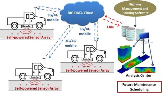
Local governments can enhance existing road maintenance vehicles with modular sensor packages. These packages may allow easy installation of cameras, LiDAR modules, and accelerometers, all connected to a centralized data processing unit. This integration facilitates real-time decision-making and efficient road repair scheduling based on automated analysis of road conditions.
Advancements and Research
Ongoing research in sensor fusion technologies and the development of more efficient deep learning algorithms continue to improve pothole detection systems. Future advancements may further reduce sensor costs, increase detection precision, and improve resilience under varying environmental conditions. Local governments stand to benefit from these innovations as they offer the potential for more predictive maintenance strategies, thereby reducing accident risks and improving overall road quality.
References
-
AI-Based Pothole Detection for Enhanced Road Safety - CyberSwift
- How AI Is Changing Pothole Detection On Roads? - EasyFlow.tech
- Pothole Detection Study by MDPI - MDPI
-
Detection of Road Potholes by Sensor Technologies - NCBI
- Pothole Detection Using Deep Learning - Wiley Online Library
Recommended Related Queries
Last updated March 26, 2025