
Unveiling the Curve: Definitive Proof Our World Isn't Flat
Discover the compelling evidence, from ancient observations to modern technology, that confirms the Earth's spherical shape.
Highlights: Key Evidence for Earth's Curvature
- Disappearing Act at the Horizon: Objects like ships vanish hull-first as they move away, a direct consequence of the Earth curving away beneath them.
- Earth's Round Shadow: During lunar eclipses, the shadow Earth casts on the Moon is consistently curved, irrefutable proof of its spherical nature, recognized since antiquity.
- Varying Starscapes & Sun Angles: The stars visible in the night sky and the Sun's angle change predictably with latitude, a phenomenon only explainable by a curved surface.
Echoes from Antiquity: Early Proofs of a Round Earth
How Ancient Thinkers Deduced Our Planet's Shape
Eratosthenes' Ingenious Calculation
One of the earliest and most celebrated proofs came from the Greek scholar Eratosthenes around 240 BCE. He observed that at noon on the summer solstice, the Sun was directly overhead in Syene (modern Aswan, Egypt), casting no shadows. However, in Alexandria, located north of Syene, vertical objects cast a distinct shadow at the same time. By measuring the angle of this shadow (about 7 degrees, or 1/50th of a circle) and knowing the distance between the two cities, Eratosthenes calculated the Earth's circumference with remarkable accuracy. This difference in shadow angles is only possible if the Sun's rays strike a curved surface at different angles. If the Earth were flat, the shadow angles would be identical.
Aristotle and the Lunar Eclipse
Even earlier, in the 4th century BCE, Aristotle noted that during a lunar eclipse, when the Earth passes between the Sun and Moon, the shadow cast by the Earth onto the Moon's surface is always circular. Regardless of Earth's orientation, the shadow maintains this round shape. Aristotle correctly deduced that the only geometric form that consistently casts a circular shadow is a sphere.
The Age of Exploration: Circumnavigation
Journeys like Ferdinand Magellan and Juan Sebastián Elcano's expedition (1519–1522) provided practical proof. By sailing continuously in one general direction (westward), they eventually returned to their starting point without falling off an edge. This feat of circumnavigation is only achievable on a closed, curved surface like a sphere.
This video explains how ancient Greek thinkers like Eratosthenes used observation and geometry to understand Earth's shape.
Observable Phenomena: Seeing the Curve in Action
Everyday Observations Confirming a Spherical World
The Disappearing Ship: Horizon Effects
One of the most intuitive proofs is observing a ship sailing away towards the horizon. You'll notice the hull disappears from view first, followed by the lower structures, and finally the mast. Conversely, an approaching ship appears mast-first. This "hull-down" phenomenon occurs because the curved surface of the Earth obstructs the lower parts of the distant object first. On a flat plane, the entire ship would simply shrink uniformly until it became too small to see.
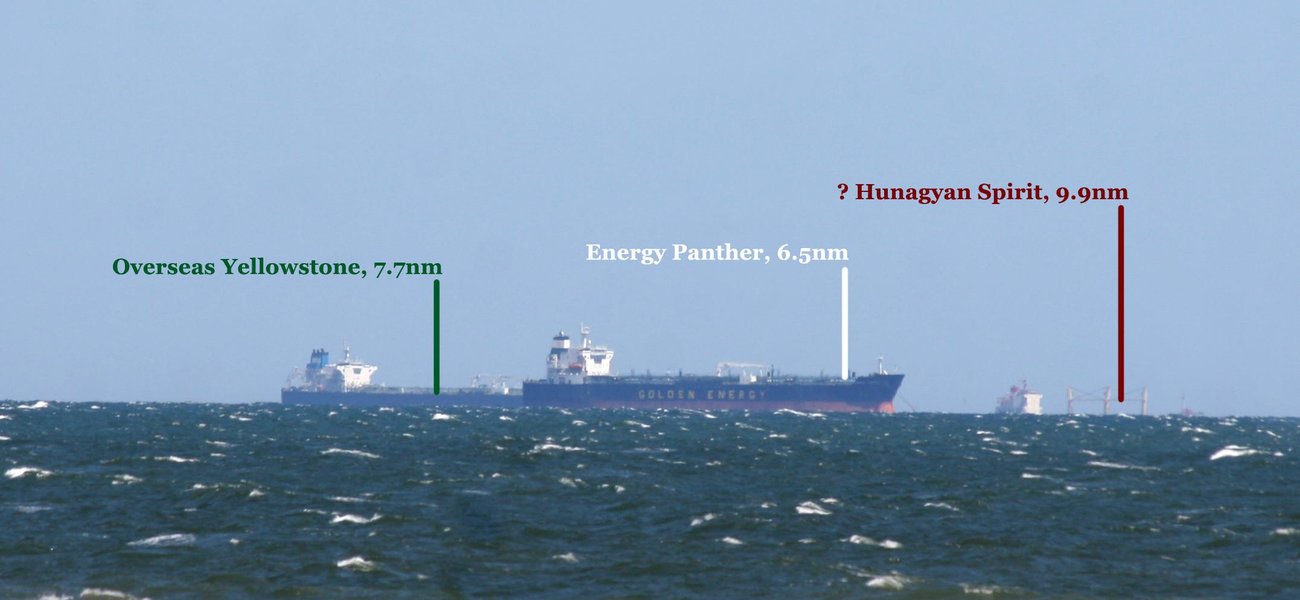
Illustration showing how ships disappear hull-first over the curved horizon.
Higher Altitude, Farther View
Climbing to a higher vantage point, like a tall building, mountain, or airplane, allows you to see farther. This expanded horizon is a direct result of Earth's curvature. From a greater height, your line of sight can extend over more of the curve before intersecting the surface. The relationship between altitude and horizon distance precisely matches the geometry of a sphere. From very high altitudes, like those reached by weather balloons or aircraft (e.g., 21,000 feet or higher), the curvature of the horizon itself becomes visually apparent.
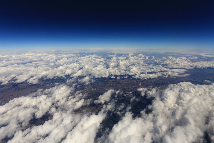
The distinct curve of the Earth's horizon as seen from an airplane window.
Changing Constellations and Sun Angles
As you travel north or south, the stars visible in the night sky change. Some constellations sink below the horizon, while others rise higher. For instance, Polaris (the North Star) appears higher in the sky as you travel north in the Northern Hemisphere and disappears below the horizon south of the equator. Similarly, the maximum height of the Sun in the sky changes with latitude. These observations are only consistent with viewing the celestial sphere from different angles on a curved surface.
Gravity's Consistent Pull
Gravity pulls objects towards the center of mass. On a spherical Earth, "down" always points towards the center of the planet, regardless of your location. This explains why people in Australia don't "fall off" – gravity pulls them towards the Earth's center just as it does for someone in North America. If the Earth were a flat disk, gravity would pull differently depending on the distance from the center, and wouldn't consistently pull straight down everywhere.
Modern Measurements and Experiments
Technological and Experimental Verification
Satellite Imagery and Space Exploration
Perhaps the most direct and undeniable proof comes from photographs and videos taken from space. Images captured by satellites, space stations, and missions to the Moon consistently show Earth as a sphere. Astronauts have directly observed Earth's roundness. The famous "Blue Marble" and "Earthrise" photos leave no doubt about our planet's shape.
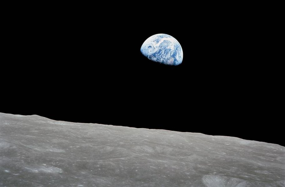
The iconic "Earthrise" photograph taken by the Apollo 8 crew in 1968, showing the Earth rising above the Moon's horizon.
Geodetic Surveys and Engineering
Large-scale engineering projects, such as long bridges and tunnels, must account for the Earth's curvature. For example, the towers supporting a long suspension bridge are not perfectly parallel; they are built vertically relative to the curved surface, meaning they are slightly farther apart at the top than at the base. Geodetic surveys, which measure positions on the Earth's surface with high precision, consistently incorporate the planet's spherical geometry.
The Bedford Level and Rainy Lake Experiments
Experiments specifically designed to measure the flatness or curvature of water surfaces over long distances have repeatedly confirmed the curve. The Bedford Level experiment, conducted on a long, straight canal in England, showed that a target set several miles away appeared lower than expected for a flat surface. More modern iterations, like the Rainy Lake Experiment, used sophisticated equipment (lasers, theodolites) over miles of frozen lake surface. These experiments carefully accounted for atmospheric refraction (the bending of light) and still measured a drop consistent with the calculated curvature of the Earth.
Global Positioning System (GPS)
The GPS network relies on a constellation of satellites orbiting the Earth. The calculations used to determine your position on Earth depend fundamentally on the satellites' positions and the assumption of a spherical (or more accurately, oblate spheroid) Earth model, including accounting for relativistic effects influenced by Earth's gravity well. The system simply wouldn't function accurately if the Earth were flat.
Quantifying the Curve
Measuring the Earth's Curvature
The Earth's curvature is not dramatic over short distances, which is why it often appears flat to the naked eye at ground level. However, it can be calculated and measured. A common approximation states that the Earth's surface drops about 8 inches for the first mile, and this drop increases with the square of the distance.
The formula for the approximate curvature drop (h) over a distance (d), assuming a perfect sphere and ignoring refraction, is:
\[ h \approx \frac{d^2}{2R} \]Where \( R \) is the Earth's radius (approximately 6,371 kilometers or 3,959 miles). For example:
- Over 1 mile (1.6 km): Drop ≈ 8 inches (20 cm)
- Over 3 miles (4.8 km): Drop ≈ 6 feet (1.8 m)
- Over 10 miles (16 km): Drop ≈ 66.7 feet (20.3 m)
While atmospheric refraction can slightly bend light rays, making distant objects appear slightly higher than they geometrically should, this effect is well-understood and accounted for in precise measurements. It does not negate the much larger effect of the Earth's curvature over significant distances.
Visualizing the Evidence: A Mindmap
Connecting the Dots of Proof
This mindmap summarizes the diverse categories of evidence demonstrating Earth's curvature, linking historical insights, observable phenomena, experimental results, and modern technological confirmation.
(Shadow Angles)"] id1b["Aristotle's Observation
(Lunar Eclipse Shadow)"] id1c["Circumnavigation
(Magellan's Voyage)"] id2["Observational Evidence"] id2a["Horizon Effect
(Ships Disappearing Hull-First)"] id2b["Altitude Effect
(Higher Viewpoint, Farther Horizon)"] id2c["Changing Star Positions
(Latitude Dependence)"] id2d["Varying Sun Angle
(Latitude Dependence)"] id2e["Gravity's Direction
(Towards Center of Mass)"] id3["Experimental Evidence"] id3a["Bedford Level Experiment
(Water Surface Curvature)"] id3b["Rainy Lake Experiment
(Laser/Theodolite Measurements)"] id3c["Long-Distance Laser Tests"] id4["Modern & Technological Proof"] id4a["Satellite Photography
(Images from Space)"] id4b["GPS Functionality
(Relies on Spherical Model)"] id4c["Geodetic Surveys
(Measurements Account for Curve)"] id4d["Large-Scale Engineering
(Bridge/Tunnel Design)"] id4e["High-Altitude Observation
(Balloons, Aircraft)"]
Comparing the Proofs: An Analytical Overview
Evaluating Different Lines of Evidence
While all lines of evidence point towards a curved Earth, they vary in their accessibility, historical significance, and reliance on technology. This chart provides a comparative perspective on some key proofs, rated on different factors from 1 (Low) to 5 (High). These ratings reflect a general assessment rather than precise quantitative values.
This visualization highlights how different proofs contribute uniquely to our understanding. For instance, the horizon effect is easily observable but less scientifically rigorous than experimental measurements, while satellite imagery provides definitive proof but requires advanced technology.
Summary Table of Evidence
A Comparative Look at Key Proofs
This table provides a concise summary of some primary methods used to demonstrate Earth's curvature, outlining the basic principle and key takeaway for each.
| Evidence Type | Methodology / Observation | Key Finding / Implication |
|---|---|---|
| Horizon Effect | Observing distant objects (e.g., ships) disappear bottom-first over the horizon. | Only possible if the surface curves away from the observer. |
| Lunar Eclipse Shadow | Observing the shape of Earth's shadow cast on the Moon during an eclipse. | The shadow is consistently round, indicating a spherical Earth. |
| Altitude & Visibility | Increased altitude allows observation of a farther horizon and reveals curvature. | Matches geometric predictions for a spherical body. |
| Varying Star Positions | Different stars/constellations are visible depending on latitude. | Only possible if observers are on a curved surface viewing a distant celestial sphere. |
| Eratosthenes' Method | Measuring differing shadow angles at noon in locations with known north-south separation. | Allows calculation of Earth's circumference, proving curvature. |
| Water Surface Experiments (e.g., Bedford Level, Rainy Lake) | Measuring line-of-sight or laser paths over long, flat bodies of water. | Detects a measurable drop consistent with Earth's radius, even accounting for refraction. |
| Satellite Imagery | Direct photographs and video footage from space. | Provides unequivocal visual confirmation of Earth's spherical shape. |
| GPS Operation | System relies on satellite positions relative to a spherical Earth model. | Accurate positioning requires accounting for Earth's shape and gravity. |
Frequently Asked Questions (FAQ)
Addressing Common Questions about Earth's Shape
Why does the Earth look flat from the ground?
Can atmospheric refraction explain away the curvature evidence?
How high do you need to be to see the curve?
Are there simple experiments I can do myself?
Recommended
- How did Eratosthenes calculate Earth's circumference?
- Explain the Bedford Level experiment in detail.
- How does atmospheric refraction affect viewing distant objects?
- At what altitude is the curvature of the Earth visible?
References
Last updated May 1, 2025