
Is Earth Really Round? Unpacking Our Planet's True Shape
Discover why Earth isn't a perfect sphere, but a fascinatingly complex shape sculpted by physics and gravity.
Quick Insights: Earth's Shape Explained
- Oblate Spheroid: Earth's primary shape is a sphere slightly flattened at the poles and bulging at the equator due to its rotation.
- The Geoid: For higher precision, scientists use the geoid model, which represents Earth's irregular shape based on gravity and mean sea level.
- Dynamic Form: Earth's shape isn't static; it constantly changes due to geological processes, tides, and mass redistribution.
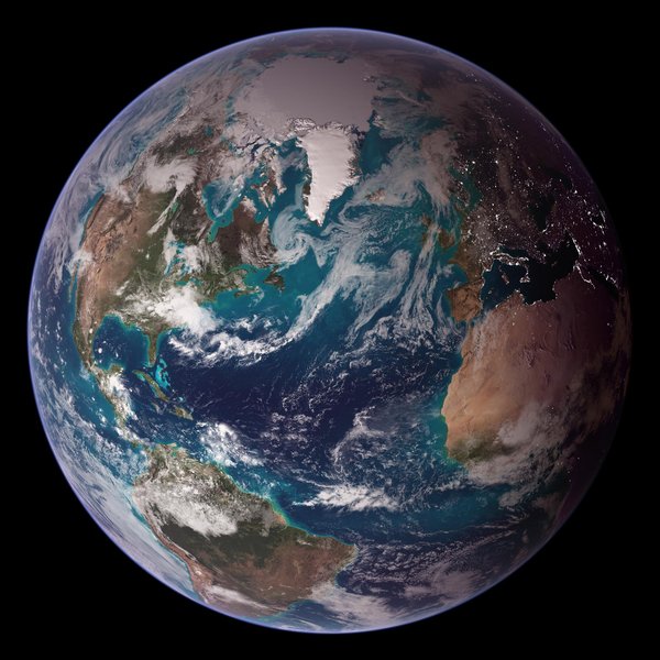
Earth as seen from space, appearing nearly spherical. NASA/GSFC
Beyond the Sphere: Unveiling the Oblate Spheroid
Why a Squashed Sphere?
While we often think of Earth as a perfect ball, its actual shape is more accurately described as an oblate spheroid. Imagine a sphere that's been slightly squashed from top to bottom and bulges out around the middle – that's essentially what an oblate spheroid is. This shape is a direct consequence of our planet's rotation.
The Spin Doctor: Rotation and Centrifugal Force
As Earth spins on its axis (completing a rotation roughly every 24 hours), it generates a centrifugal force. This force acts outwards, perpendicular to the axis of rotation, and is strongest at the equator and zero at the poles. Think of spinning a wet tennis ball – water flies off most vigorously from its "equator." Similarly, Earth's rotational force causes mass (rock, water) to push outwards more at the equator, leading to an equatorial bulge. Conversely, the areas near the poles experience less of this outward force and are slightly flattened.
This concept was first theorized by Sir Isaac Newton in the 17th century, based on his understanding of gravity and mechanics. He predicted that the combination of gravity pulling mass inward and centrifugal force pushing it outward would result in an oblate shape. Subsequent measurements and expeditions, particularly in the 18th century, confirmed his hypothesis.

Conceptual illustration showing the difference between a sphere and an oblate spheroid (exaggerated). Geography.name
Measurable Differences: Equatorial vs. Polar Dimensions
The difference caused by this oblateness is subtle but significant for science and technology. The Earth's diameter measured through the equator is longer than the diameter measured between the poles.
Here's a comparison of the approximate dimensions:
| Measurement | Equatorial | Polar | Difference |
|---|---|---|---|
| Radius | ~6,378 km (3,963 miles) | ~6,357 km (3,950 miles) | ~21 km (13 miles) |
| Diameter | ~12,756 km (7,926 miles) | ~12,714 km (7,900 miles) | ~43 km (27 miles) |
Comparison of Earth's approximate equatorial and polar dimensions.
This difference means Earth is about 0.33% wider at the equator than it is tall from pole to pole. While you wouldn't notice this visual difference from space with the naked eye, it's crucial for accurate calculations in fields like navigation, satellite tracking, and geodesy (the science of measuring Earth's shape).
Digging Deeper: Introducing the Geoid
The "True" Gravitational Shape
While the oblate spheroid provides a good mathematical approximation of Earth's overall form, the planet's actual shape is even more complex. The most precise representation is called the geoid. The geoid isn't a purely geometric shape like an ellipsoid; instead, it's defined by Earth's gravity field.
Imagine the entire planet covered by a calm ocean, with no tides, currents, or winds. The surface this global ocean would settle into, solely under the influence of gravity and Earth's rotation, is the geoid. It represents an equipotential surface, meaning the gravitational potential energy is the same at every point on it. In practical terms, the geoid approximates mean sea level across the globe.
Why the Irregularity? Lumps and Bumps
Unlike the smooth, mathematical surface of an ellipsoid, the geoid is irregular – often described colloquially as "lumpy" or "potato-shaped." This irregularity arises because Earth's mass is not distributed perfectly uniformly. Factors contributing to these variations include:
- Mountains and Valleys: Large geological features like the Himalayas or the Mariana Trench create concentrations or deficits of mass.
- Density Variations: Differences in the density of materials within the Earth's crust and mantle affect the local gravitational pull.
- Ocean Trenches: Deep parts of the ocean represent less mass compared to continental areas.
Where there's more mass (like under a mountain range), gravity is slightly stronger, pulling the geoid surface upwards relative to the reference ellipsoid. Where there's less mass (like over an ocean trench), gravity is weaker, and the geoid surface dips downwards. These variations mean the geoid undulates above and below the smooth surface of the reference ellipsoid by amounts ranging up to about 100 meters (roughly 330 feet).
Geoid vs. Ellipsoid: When Precision Matters
So, which shape is "real"? Both the oblate spheroid (ellipsoid) and the geoid are models used to describe Earth's shape, but for different purposes:
- Oblate Spheroid/Ellipsoid: This is a simplified, geometrically defined shape used as a reference for coordinate systems (latitude, longitude, height). It's essential for mapping, GPS, and navigation because it provides a smooth mathematical surface to work with.
- Geoid: This represents the physical reality of Earth's gravity field and mean sea level. It's crucial for applications requiring precise elevation data relative to sea level, such as civil engineering (e.g., large-scale construction projects, water flow modeling) and oceanography. GPS systems, for example, initially calculate height relative to the reference ellipsoid, which must then be corrected using a geoid model to determine height above mean sea level.
In essence, the ellipsoid gives us a reference framework, while the geoid provides a more physically accurate picture of Earth's complex gravitational surface.
Modeling the Earth: Ellipsoids and Datums
The Role of Reference Ellipsoids
To create maps and define locations accurately across the globe, scientists and cartographers rely on standardized mathematical models of Earth's shape called reference ellipsoids. These are specific types of oblate spheroids with precisely defined parameters: the length of the semi-major axis (equatorial radius), the length of the semi-minor axis (polar radius), and the flattening.
Different reference ellipsoids have been developed over time, optimized for better fits in specific regions or for global use. Examples include WGS 84 (World Geodetic System 1984) and GRS 80 (Geodetic Reference System 1980).
Datums in Practice: Pinpointing Locations
A reference ellipsoid alone isn't enough; we also need a way to anchor it to the actual Earth. This is where geodetic datums come in. A datum defines the origin and orientation of the coordinate system (latitude, longitude, height) used with a specific reference ellipsoid.
Common datums include:
- WGS 84: A global datum used by the Global Positioning System (GPS). It uses the WGS 84 ellipsoid.
- NAD 83 (North American Datum 1983): Used primarily in North America. It is based on the GRS 80 ellipsoid.
These datums are fundamental for ensuring consistency in mapping, surveying, navigation, and geographic information systems (GIS). When your GPS device gives you coordinates, it's calculating your position relative to a specific datum, typically WGS 84.
Visualizing Earth Shape Models
The relationship between these different ways of describing Earth's shape can be visualized as a progression from simple approximations to more complex, accurate models. The following mind map illustrates this hierarchy:
Mind map showing the hierarchy and applications of different Earth shape models.
A Dynamic Planet: Earth's Ever-Changing Form
Not Set in Stone
It's important to understand that Earth's shape, whether described by the ellipsoid or the geoid, is not static. Our planet is a dynamic system, and its form undergoes continuous, albeit often slow, changes driven by various natural processes:
- Plate Tectonics: The constant movement of tectonic plates reshapes continents, builds mountains, and forms ocean trenches, altering the distribution of mass and influencing the geoid.
- Tides: The gravitational pull of the Moon and Sun causes tides, which involve vast movements of water, temporarily changing the shape of the ocean surface (and slightly deforming the solid Earth).
- Post-Glacial Rebound: Areas covered by massive ice sheets during the last ice age were pushed down by the weight. As the ice melted, the land slowly started "rebounding" upwards, a process still ongoing in regions like Scandinavia and Canada, changing local elevations and gravity.
- Melting Ice Caps and Glaciers: As climate change causes ice sheets in Greenland and Antarctica to melt, the redistribution of water mass into the oceans subtly alters Earth's gravitational field and rotation, impacting both the geoid and the planet's oblateness over time.
- Large Earthquakes: Major earthquakes can cause significant shifts in the Earth's crust over large areas, instantaneously changing local topography and slightly altering the mass distribution.
Scientists use sophisticated techniques, including satellite laser ranging (SLR), GPS networks, and gravity-measuring satellites (like GRACE and GOCE), to monitor these subtle changes in Earth's shape and gravity field with remarkable precision.
Relative Influence on Earth's Shape
Different factors contribute varying degrees to Earth's overall shape versus its local surface features. The chart below provides an illustrative comparison of the relative impact of key factors. "Overall Shape" refers to the fundamental oblate spheroid form, while "Local Features/Geoid" refers to the irregularities and dynamic changes on the surface and in the gravity field.
Illustrative radar chart comparing the relative influence of various factors on Earth's overall shape versus its local features and geoid irregularities.
Historical Perspectives and Modern Confirmation
From Theory to Measurement
The understanding that Earth is not perfectly spherical has evolved over centuries. Following Newton's theoretical prediction, the French Academy of Sciences sponsored expeditions in the mid-18th century to Peru (near the equator) and Lapland (in the Arctic). By measuring the length of a degree of latitude in both locations, they confirmed that Earth was indeed flattened at the poles, supporting the oblate spheroid model.
Confirming Earth's Shape from Above
Modern technology provides undeniable confirmation and incredibly precise measurements of Earth's shape. Satellites orbiting the planet constantly measure its surface features and gravitational field. Techniques like:
- Satellite Altimetry: Measures the height of the sea surface, revealing the shape of the geoid over the oceans.
- Satellite Gravimetry: Missions like GRACE and GOCE precisely map Earth's gravity field, allowing scientists to model the geoid globally with high resolution.
- GPS and Geodetic Networks: Ground-based receivers continuously track signals from GPS satellites, enabling measurements of crustal movements and changes in Earth's shape with millimeter accuracy.
- Satellite Laser Ranging (SLR): Lasers are bounced off satellites, and the travel time is measured precisely to track satellite orbits, which are influenced by Earth's gravity field and shape.
- Very Long Baseline Interferometry (VLBI): Uses radio telescopes to observe distant quasars, providing a stable reference frame to measure continental drift and Earth's rotation variations.
These technologies not only confirm the oblate spheroid shape and the complex geoid but also allow us to observe the dynamic changes occurring on our planet.
Visualizing Earth's True Shape
The following video provides a concise explanation of Earth's actual shape, touching upon the concepts of the oblate spheroid and the equatorial bulge.
Video explaining Earth's subtle equatorial bulge and why it's not a perfect sphere.
Frequently Asked Questions (FAQ)
Is the Earth perfectly round?
No, the Earth is not perfectly round like a mathematical sphere. While it appears generally round from space, precise measurements show it's slightly flattened at the poles and bulges at the equator. Its shape is best described as an oblate spheroid or, more accurately for gravitational purposes, a geoid.
Why isn't the Earth a perfect sphere?
The main reason is its rotation. The centrifugal force generated by Earth spinning on its axis pushes mass outwards, most strongly at the equator. This causes the equatorial region to bulge out and the polar regions to flatten slightly. Gravity pulls everything inwards, but the outward centrifugal force counteracts it more effectively at the equator.
What's the difference between an oblate spheroid and a geoid?
An oblate spheroid (or ellipsoid) is a smooth, mathematical shape that approximates Earth's overall form (flattened poles, bulging equator). It's used as a reference for coordinate systems like latitude and longitude.
The geoid is a more complex, irregular surface that represents Earth's mean sea level based on its actual gravity field. It accounts for variations due to mountains, trenches, and density differences. The geoid is a better representation of the "physical" shape related to gravity potential.
How do we know the Earth's shape?
Our knowledge comes from various sources:
- Satellite Measurements: Satellites measure distances, gravity variations, and sea surface height with high precision (e.g., GPS, satellite altimetry, gravimetry).
- Geodetic Surveys: Ground-based measurements using techniques like VLBI and SLR track Earth's rotation and crustal movements.
- Historical Expeditions: Early measurements of latitude arcs confirmed the polar flattening.
- Astronomy: Observations of how Earth interacts gravitationally with other celestial bodies support its measured mass and shape.
- Images from Space: While showing a generally round appearance, detailed analysis supports the measured dimensions.
Does the Earth's shape change?
Yes, Earth's shape is dynamic and constantly changing, although often very slowly. Factors like plate tectonics, post-glacial rebound, melting ice sheets, large earthquakes, and even tides cause continuous adjustments to the planet's surface, gravity field, and overall form.
Recommended Reading
- Explore the concept of the geoid and the satellite technology used to measure it.
- Learn more about the physics behind centrifugal force and its impact on planetary shapes.
- Discover the importance of reference ellipsoids and datums in GPS and mapping.
- Investigate the effects of melting ice caps and water redistribution on Earth's rotation and shape.
References
Last updated April 27, 2025