
Mapping Coral Reef Concentrations in the Coral Triangle
An in-depth exploration of biodiversity, mapping techniques, and conservation efforts
Key Highlights
- Rich Biodiversity: The region hosts over 76% of the world’s shallow-water reef-building coral species and 37% of reef fish species.
- Advanced Mapping Techniques: Utilization of Geographic Information Systems (GIS), satellite imagery, and interactive atlases to spatially analyze coral reef distributions.
- Comprehensive Conservation: Collaborative efforts among Coral Triangle nations and international organizations to secure and manage high biodiversity areas.
Overview of the Coral Triangle
The Coral Triangle represents one of the world’s most complex and biodiverse marine regions. Spanning roughly 4 to 6 million square kilometers in the western Pacific Ocean, it includes the waters of Indonesia, Malaysia, Papua New Guinea, the Philippines, Timor-Leste, and Solomon Islands. Often referred to as the "Amazon of the seas," the Coral Triangle is celebrated for its extraordinary assortment of marine life, making it a focal point for both scientific research and conservation efforts.
Biodiversity and Its Significance
The region’s biodiversity is staggering. It is home to over 605 species of reef-building corals, which constitute more than 76% of the world’s shallow-water coral species. In addition, the Coral Triangle houses more than 2,000 species of reef fishes. High-density areas such as the Verde Island Passage in the Philippines and the Bird’s Head Seascape in Indonesian Papua exemplify regions where marine species richness reaches its peak. This diversity underpins the ecological resilience of the area and its importance to global marine ecosystems.
Ecological Importance
Coral reefs provide essential services including coastal protection, fishery support, and livelihoods for millions of people. The dense aggregation of coral reef species not only sustains local economies but also contributes to the overall health of ocean systems. Understanding and mapping these concentrations is crucial for both ecological research and the development of targeted conservation strategies.
Mapping Techniques and Tools
Geographic Information Systems (GIS) and Interactive Atlases
A cornerstone of mapping efforts in the Coral Triangle involves the use of Geographic Information Systems (GIS). GIS technology enables the integration of various datasets, such as biodiversity records, environmental variables, and spatial data from satellite imagery, to produce detailed maps of coral reef concentrations. One of the most renowned tools is the Coral Triangle Atlas, which aggregates extensive data on coral distributions, marine protected areas, and biodiversity hotspots.
Interactive Atlases and Online Databases
Interactive atlases like the Coral Triangle Atlas empower researchers and policymakers by providing user-friendly interfaces to visualize biodiversity data. These platforms combine data layers including bathymetry, coral cover, and human impacts, allowing for dynamic analysis of reef health and spatial distribution. The information gleaned from these resources can guide the establishment of conservation areas and track changes in reef ecosystems over time.
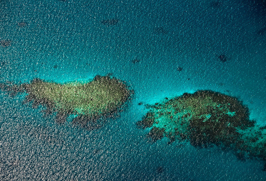
Satellite Imagery and Remote Sensing
Incorporating satellite imagery into mapping projects has revolutionized the way researchers monitor coral reefs. High-resolution images sourced from satellites, such as those from the Landsat program, are critical for detecting changes in coral cover and reef structure. These images help delineate reef boundaries, assess damage following bleaching events, and monitor recovery processes. Advanced remote sensing techniques allow for continuous monitoring of extensive and remote reef systems, providing near real-time data to support active conservation measures.
Technological Integration
The integration of GIS with high-definition satellite data offers a robust framework for understanding spatial patterns in reef distribution. This technology is essential not only for mapping current conditions but also for predictive modeling of how reefs may respond to threats like climate change, pollution, and overfishing. Predictive models are increasingly important for forecasting shifts in biodiversity and guiding proactive conservation.
Data Collection and Spatial Analysis
Detailed mapping requires comprehensive data collection from various sources. Field surveys, diver observations, underwater drones, and acoustic monitoring contribute to building an extensive database of coral species, reef structures, and environmental factors. When combined with GIS, these data support spatial analyses that highlight critical areas of biodiversity.
Steps in Mapping Coral Reefs
The process typically involves:
- Data Collection: Gathering information from scientific surveys, remote sensing, and local community reports.
- Spatial Analysis: Utilizing GIS to overlay various data layers, identify biodiversity hotspots, and determine reef boundaries.
- Visualization: Creating detailed maps that illustrate coral densities, reef health, and areas at risk.
- Conservation Planning: Using mapped data to guide the establishment of marine protected areas and inform policy decisions.
Conservation Efforts and Collaborative Initiatives
Regional and International Partnerships
Recognizing the intrinsic value of the Coral Triangle’s diverse ecosystems, several multinational initiatives have emerged to conserve and sustainably manage these marine resources. Notably, the Coral Triangle Initiative (CTI) embraces multilateral cooperation among the six nations in the region. This collaboration aims to mitigate threats from overfishing, coastal development, pollution, and climate change, while also ensuring food security and economic stability for local communities.
Conservation Targets for 2025
The CTI and its partners have set ambitious conservation targets for 2025. These include not only preserving the vast coral biodiversity but also rehabilitating degraded reef areas. By applying rigorous mapping techniques, nations involved can pinpoint priority areas for protection and restoration. Initiatives often focus on regions identified as biodiversity hotspots, such as the Verde Island Passage and the Bird’s Head Seascape.
Role of Local Communities and NGOs
Engaging local communities is pivotal in every phase of conservation. Community-based management practices have proven effective in reducing unsustainable fishing and other local threats. Additionally, non-governmental organizations (NGOs) and research institutions provide essential support in monitoring reef health and conducting extensive mapping exercises. By collaborating with local stakeholders, these organizations help ensure that conservation measures are both culturally relevant and scientifically robust.
Case Study: Marine Protected Areas (MPAs)
MPAs in the Coral Triangle serve as practical examples of how data-driven mapping guides conservation. In areas where comprehensive mapping has revealed high coral and fish biodiversity, MPAs are established to safeguard these resources against human-induced stressors. Scientific monitoring post-establishment often shows significant improvements in reef resilience and species recovery, underscoring the efficacy of an informed, strategic conservation approach.
Detailed Mapping Data and Comparative Analysis
Coral Reef Concentration Mapping Table
The following table provides an illustrative overview of key data points collected from various research and mapping initiatives within the Coral Triangle:
| Region/Area | Biodiversity Significance | Key Mapping Tools | Conservation Priorities |
|---|---|---|---|
| Verde Island Passage, Philippines | Highest concentration of reef fish species; rich coral biodiversity | GIS, Satellite Imagery, Coral Triangle Atlas | Establishing MPAs, stringent fishing regulations |
| Bird’s Head Seascape, Indonesia | Important coral and fish species aggregation | Remote sensing, Differential analysis via GIS | Habitat preservation, pollution control |
| Solomon Islands and Timor-Leste Waters | Diverse coral species and significant unknown species populations | Field surveys, Satellite imaging integrated into GIS | Sustainable fishing practices, restoration projects |
Implications for Future Research
Detailed and dynamic mapping of coral reef concentrations not only enhances our understanding of the region’s ecological complexity but also supports effective resource management decisions. It empowers policymakers with the data needed to allocate conservation funding efficiently. Researchers continue to refine mapping methodologies by incorporating innovative data sources and advanced algorithms, such as change detection models, that predict reef health under future climate scenarios.
Technological Advances and Environmental Policy
As technology evolves, so will our capacity to monitor and manage the Coral Triangle. The integration of real-time monitoring tools and machine learning offers promising advancements in detecting reef degradation early. Furthermore, environmental policies driven by such scientific evidence can lead to practical, enforceable guidelines that balance ecological demands with local economic activities.
Challenges and Future Directions
Threats to Coral Reefs
Despite the significant strides in mapping and conservation, the Coral Triangle remains vulnerable to a range of anthropogenic pressures. Unsustainable fishing, coastal development, pollution, and the pervasive impacts of climate change forefront the list of persistent challenges. Bleaching events, driven by rising water temperatures, have particularly devastating effects on coral health, disrupting the delicate balance of these ecosystems.
Mitigation Strategies
Addressing these issues requires coordinated mitigation strategies. Mapping technologies not only assist in pinpointing vulnerable regions but also facilitate rapid response mechanisms during environmental crises. Continued international collaboration, public awareness programs, and stricter enforcement of environmental laws are required to enhance the resilience of coral reef ecosystems.
Opportunities for Enhanced Mapping
The future of coral reef mapping lies in embracing emerging technologies such as unmanned underwater vehicles (UUVs) and advanced remote sensing techniques. Innovations in these areas will drive even more granular studies of reef dynamics, enabling scientists to capture subtle changes in aquatic ecosystems. Moreover, the integration of citizen science initiatives may further broaden data collection, as local divers and community members contribute valuable observations.
Long-term Monitoring and Adaptive Management
Long-term ecosystem monitoring is fundamental for detecting trends and refining adaptive management practices. Maintaining a detailed historical record of reef conditions allows stakeholders to understand long-term impacts of environmental stressors, adjust management strategies accordingly, and ultimately guide the future of marine conservation in the Coral Triangle.
References
- Coral Triangle - Wikipedia
- Coral Triangle - CORAL
- WWF - Coral Triangle
- Reef World - Coral Triangle Facts
- Coral Triangle Atlas
Recommended Related Queries
Last updated March 9, 2025