
Comprehensive Guide to Conducting Hydrographic and Bathymetric Surveys Using Unmanned Surface Vehicles (USVs)
Harnessing USV Technology for Accurate and Efficient Waterbody Mapping
Key Takeaways
- Strategic Planning and Preparation: Essential for mission success, encompassing area assessment and equipment selection.
- Advanced Sensor Integration: Utilizing high-precision sensors for accurate data collection.
- Comprehensive Data Processing: Ensuring data integrity and generating detailed bathymetric maps.
1. Planning and Preparation
1.1 Survey Area Assessment
The first step in conducting a hydrographic and bathymetric survey using a USV is to thoroughly assess the survey area. This includes evaluating the water conditions, depth variations, underwater terrain, and potential obstacles that might interfere with the USV's operation.
Environmental Conditions
Understanding the environmental conditions such as tides, currents, weather patterns, and visibility is crucial. These factors can significantly affect the USV's performance and data accuracy. Seasonal variations and unexpected weather changes should also be considered during the planning stage.
1.2 Defining Objectives and Data Requirements
Clearly defining the survey objectives and data requirements ensures that the mission aligns with project goals. Determine the specific data needed, such as water depth, sub-bottom profiles, or side-scan imaging. Establishing target accuracy and resolution based on regulatory standards or project specifications is essential for producing reliable results.
1.3 Selecting the Appropriate USV
Selecting the right USV is pivotal for the success of the survey mission. Key factors to consider include the USV's size, maneuverability, sensor compatibility, autonomy level, data processing capabilities, and cost. Popular models like the BlueBoat by Blue Robotics and CEE-USV by CEE Hydrosystems offer specialized features for bathymetric surveys, including precise navigation and multiple sensor mounting points.
2. Equipping the USV
2.1 Sensor Payload Configuration
Equipping the USV with the appropriate sensors is critical for accurate data collection. Commonly used sensors include echo sounders for depth measurements, GNSS receivers with Real-Time Kinematic (RTK) for precise positioning, and additional instruments for measuring water quality, temperature, or currents. Depending on the survey's scope, side-scan sonar or sub-bottom profilers may also be integrated.
2.2 Data Acquisition and Control Systems
Integrating a robust data acquisition and control system ensures seamless data collection and real-time monitoring. The system should facilitate real-time communication links, such as telemetry or wireless connections, enabling remote monitoring and adjustments during the survey. Onboard data storage and backup systems are essential to safeguard the acquired data against potential loss or corruption.
2.3 USV Modifications and Enhancements
Depending on the payload weight and power requirements of the sensors, the USV may require modifications to its power system and flotation characteristics. Ensuring that the USV can handle the additional weight without compromising stability and maneuverability is crucial. Vibration isolation systems should be considered for sensitive instruments to prevent data inaccuracies caused by USV movements.
3. Pre-Mission Checks and Calibration
3.1 Sensor Calibration
Accurate sensor calibration is fundamental for reliable data collection. Calibrate echo sounders at known depth points to ensure depth measurements are precise. Set up GNSS RTK base stations to enhance positioning accuracy. Additionally, calibrate inertial measurement units (IMUs) to maintain correct sensor orientation and mitigate the impact of the USV's movements on data quality.
3.2 System Integrity and Functionality Checks
Conduct comprehensive system checks to verify the operational status of all components. Perform a dry-run to test data collection processes, communication links, and autonomous navigation systems. Ensure that all safety mechanisms are functional and that the USV is in optimal mechanical condition to withstand the survey environment.
4. Mission Execution
4.1 Deployment and Launch
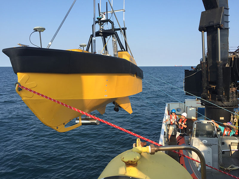
Deploy the USV in a controlled and safe manner from shore or a support vessel. Ensure that the entry and recovery points are free from obstructions and provide sufficient space for the USV to navigate during and after the survey. For extensive missions, consider using support vessels or monitoring stations to oversee the USV's progress.
4.2 Autonomous Navigation and Data Collection
Activate the USV's autonomous navigation system, ensuring it follows the pre-programmed survey lines accurately. Maintain a consistent speed suitable for the sensors to capture high-quality data without missing critical information. Real-time monitoring of sensor feedback allows for immediate adjustments to the USV's course in response to environmental changes or obstacles.
4.3 Adaptive Management
Be prepared to adapt the survey plan if unexpected conditions arise. This includes modifying survey paths to navigate around obstacles or adjusting data collection parameters in response to sensor interference or errors. Effective adaptive management ensures the survey can continue smoothly despite unforeseen challenges.
5. Post-Mission Data Processing
5.1 Data Retrieval and Backup
After completing the survey, retrieve all collected data from the USV and create secure backup copies. Verifying the integrity of the datasets prevents data loss and ensures that all information can be reliably used for subsequent analysis.
5.2 Data Processing and Quality Control
Utilize specialized hydrographic software to process the collected bathymetric data. Merge depth measurements with GNSS coordinates to create georeferenced maps. Apply necessary corrections, such as sound velocity and tide adjustments, to enhance data accuracy. Conduct quality control checks to identify and rectify any anomalies or inconsistencies in the data.
5.3 Analysis and Reporting
Analyze the processed datasets to extract meaningful insights and meet project objectives. Generate detailed depth maps and underwater terrain models to visualize the surveyed area comprehensively. Prepare comprehensive reports that include survey accuracy, coverage details, and any noteworthy findings or anomalies discovered during the mission.
6. Safety and Efficiency Considerations
6.1 Enhancing Safety
Utilizing USVs for hydrographic and bathymetric surveys significantly enhances safety by eliminating the need for human presence in potentially hazardous environments. USVs can continuously operate without fatigue, reducing the risk of accidents associated with extended survey operations.
6.2 Cost and Time Efficiency
USVs offer substantial cost savings compared to traditional manned survey vessels by minimizing labor costs and operational expenses. Their ability to autonomously perform long-duration surveys without the need for regular breaks increases overall efficiency, enabling timely completion of survey missions.
6.3 Regulatory Compliance
Ensure that the survey complies with relevant standards and regulations set by national hydrographic offices or the International Hydrographic Organization. Adhering to legal and safety guidelines for unmanned operations is essential for the legitimacy and acceptance of the survey results.
7. Practical Example: USV-Based Hydrographic Survey Workflow
| Stage | Activities | Tools/Equipment |
|---|---|---|
| Planning | Define objectives, assess area, select USV | Survey software, environmental data |
| Equipment Setup | Install sensors, configure data systems | Echo sounders, GNSS RTK, control systems |
| Pre-Mission | Calibrate sensors, perform system checks | Calibration tools, testing software |
| Execution | Deploy USV, collect data autonomously | USV control station, monitoring systems |
| Post-Mission | Retrieve data, process and analyze | Hydrographic software, GIS tools |
| Reporting | Generate maps, prepare reports | Visualization tools, documentation software |
8. Advanced Techniques and Technologies
8.1 Integration of Sub-Bottom Profiler
Sub-bottom profilers provide valuable information about the sediment layers beneath the seafloor. Integrating these profilers with USVs enhances the survey's depth, allowing for a more comprehensive understanding of underwater geological features.
8.2 Side-Scan Sonar Applications
Side-scan sonar technology enables detailed imaging of the seafloor, revealing features such as shipwrecks, underwater obstructions, and biological habitats. When combined with bathymetric data, side-scan sonar offers a multidimensional view of the surveyed area.
8.3 Real-Time Data Processing and Visualization
Implementing real-time data processing and visualization tools allows surveyors to monitor data quality and make immediate adjustments to the survey parameters. Advanced software solutions can display bathymetric data in real-time, facilitating prompt decision-making and enhancing the overall efficiency of the mission.
9. Troubleshooting Common Challenges
9.1 Navigational Errors
Navigational errors can occur due to GPS signal loss, IMU inaccuracies, or unexpected obstacles. To mitigate these issues, ensure robust sensor calibration, use redundant navigation systems, and incorporate obstacle detection and avoidance technologies.
9.2 Data Quality Issues
Inaccurate data can result from sensor malfunctions, environmental interferences, or improper calibration. Regular maintenance, thorough pre-mission checks, and real-time monitoring can help detect and correct data quality issues promptly.
9.3 Communication Failures
Reliable communication links are vital for real-time monitoring and control. Utilize high-quality telemetry systems and establish fallback communication protocols to prevent mission disruptions caused by communication failures.
10. Future Trends in USV-Based Hydrographic Surveys
10.1 Autonomous Decision-Making
Advances in artificial intelligence and machine learning are enabling USVs to make autonomous decisions during survey missions. This includes adaptive path planning, real-time data analysis, and autonomous obstacle avoidance, further enhancing the efficiency and reliability of hydrographic surveys.
10.2 Enhanced Sensor Technologies
Emerging sensor technologies are improving the accuracy and depth of hydrographic and bathymetric surveys. Innovations such as higher resolution multibeam sonar systems and improved sub-bottom profilers provide more detailed and precise data, expanding the capabilities of USV-based surveys.
10.3 Integration with Other Unmanned Systems
Integrating USVs with other unmanned systems, such as aerial drones (UAVs) and underwater drones (UUVs), can create a comprehensive unmanned survey ecosystem. This integration allows for multi-layered data collection, providing a holistic view of the surveyed waterbody.
Conclusion
Utilizing Unmanned Surface Vehicles (USVs) for hydrographic and bathymetric surveys offers numerous advantages, including enhanced safety, cost-efficiency, and the ability to conduct detailed and accurate waterbody mapping. By meticulously planning the mission, equipping the USV with advanced sensors, ensuring thorough pre-mission checks, and employing comprehensive data processing techniques, surveyors can achieve high-quality results that meet or exceed project requirements. As technology continues to advance, USV-based hydrographic surveying is poised to become even more integral to marine and freshwater mapping endeavors.
References
Last updated February 14, 2025