
Mapping the Genesis: Unpacking the First Decade of Volunteered Geographic Information Research
A deep dive into the seminal 2020 review by Yan et al. that charted the course of VGI in GIScience from 2007 to 2017.
Highlights of the Yan et al. (2020) VGI Review
- Comprehensive Scope: Analyzed 346 peer-reviewed articles from 24 GIScience journals published between 2007 and 2017, identifying key research trajectories.
- Thematic Organization: Structured the vast body of research into three overarching themes: VGI contributions/contributors, application fields, and conceptual/future visions.
- Foundational Impact: Established as a landmark review, synthesizing the critical first decade of VGI research and highlighting persistent challenges like data quality and integration.
Context: VGI and the Genesis of the Review
What is Volunteered Geographic Information (VGI)?
Volunteered Geographic Information (VGI) refers to geographic data generated and shared voluntarily by individuals, often acting as "citizen sensors." Coined by Michael Goodchild in 2007, VGI represents a paradigm shift from traditional, authoritative mapping agencies towards harnessing the power of the crowd. It encompasses a wide range of user-generated spatial content, from mapping features in platforms like OpenStreetMap (OSM) to geotagging photos or reporting environmental observations via mobile apps. VGI is closely related to citizen science and user-generated content, leveraging public participation to create rich, diverse, and often real-time geographic datasets.
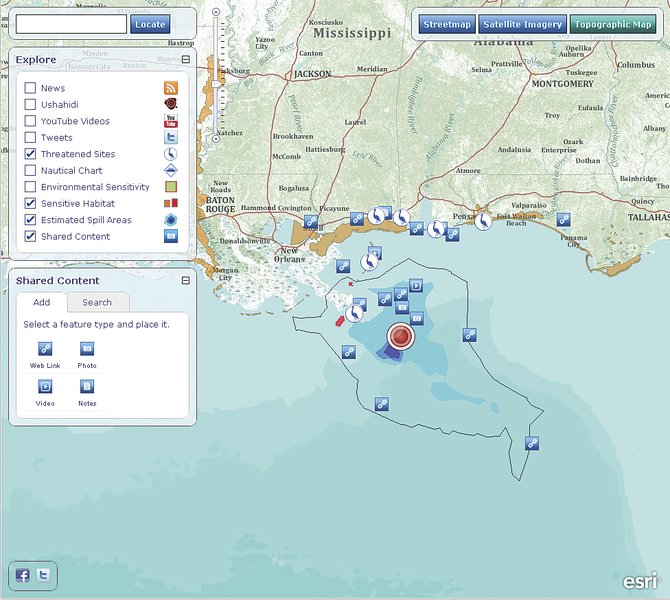
Conceptualizing the flow and application of Volunteered Geographic Information.
Why Review the First Decade?
The period from 2007 to 2017 marked the formative years of VGI as a distinct research field within Geographic Information Science (GIScience). Following Goodchild's conceptualization, research activity surged, exploring VGI's potential, applications, and inherent challenges. Yan et al. (2020) undertook their review to synthesize this burgeoning body of work, aiming to understand the evolution of research themes, identify dominant trends, pinpoint persistent gaps, and provide a structured overview for researchers. Documenting this first decade was crucial for consolidating knowledge, assessing the field's maturation, and charting future research directions.
Deep Dive into the Yan et al. (2020) Review
Scope and Rigorous Methodology
Data Collection and Analysis
The review meticulously compiled a dataset of 346 VGI-related articles published between November 20, 2007, and November 20, 2017. These articles were sourced from 24 prominent, peer-reviewed international journals indexed by the Science Citation Index, ensuring a focus on high-impact GIScience research. The authors employed both narrative synthesis and advanced bibliometric and text-mining techniques, notably Latent Dirichlet Allocation (LDA) topic modeling, to systematically analyze the content and structure of the VGI literature.
Hierarchical Thematic Structure
A key contribution of the paper was its hierarchical organization of the research landscape. Using LDA, the authors first identified 50 discrete research topics within the 346 articles. These topics were then clustered into 13 intermediate, more cohesive thematic groups. Finally, these intermediate groups were aggregated into three overarching themes, providing a multi-level understanding of the dominant areas of focus and their interconnections within VGI research during its first decade. This structured approach allowed for a nuanced narrative that went beyond simple categorization, revealing the intellectual architecture of the field.
Unpacking the Three Pillars of VGI Research (2007-2017)
The review structured the VGI literature around three core pillars:
1. VGI Contributions and Contributors
This theme delves into the 'who, what, why, and how' of VGI creation. Research under this pillar examined the characteristics and demographics of volunteers, their motivations for contributing (ranging from altruism to personal interest), the types of geographic information being contributed, and the processes of data generation. A significant portion of research within this theme also grappled with the critical issue of VGI data quality, exploring its variability and the factors influencing contributor accuracy.
2. Main Fields Applying VGI
This pillar highlights the diverse practical applications of VGI. The review identified key domains where VGI made significant inroads. Prominent examples include:
- Disaster Management and Crisis Mapping: Using VGI for real-time situational awareness, damage assessment, and resource allocation during emergencies (e.g., earthquakes, floods).
- Urban Planning and Monitoring: Leveraging VGI for updating land use maps, monitoring urban change, and understanding spatial patterns of human activity.
- Environmental Monitoring: Utilizing citizen-reported data for tracking biodiversity, mapping environmental hazards, or monitoring pollution levels.
- Citizen Science Initiatives: Many VGI projects overlap significantly with broader citizen science goals, engaging the public in scientific data collection.
3. Conceptions and Envisions
This theme addresses the theoretical, methodological, and future-oriented aspects of VGI research. It encompasses how VGI is conceptualized within GIScience, the development of analytical frameworks and methodologies for processing and validating VGI, discussions on inherent biases and representativeness, ethical considerations (like privacy), and visions for the future integration of VGI with authoritative data sources, sensor networks (citizen sensing), and emerging technologies like machine learning. Assessing and communicating VGI quality remains a central concern within this theme.
Visualizing the VGI Research Landscape
A Mindmap of VGI Research Themes (2007-2017)
This mindmap visualizes the hierarchical structure identified by Yan et al. (2020), showing the three main pillars of VGI research during its first decade and some key sub-topics within each. It helps illustrate the interconnectedness and breadth of the research landscape reviewed in the paper.
Key Research Areas: A Comparative Look
The radar chart below offers a conceptual representation of the relative focus and evolution of research interest across key VGI domains during the first decade, as synthesized from the review. It compares perceived research intensity in the earlier part of the decade (2007-2012) versus the latter part (2013-2017), alongside areas identified as needing future attention. Note that these values are illustrative interpretations based on the review's findings, not precise quantitative measures.
Major Findings, Trends, and Identified Gaps
Key Trends Shaping VGI Research
The review by Yan et al. highlighted several dominant trends during VGI's first decade:
- Focus on Data Quality: Assessing, validating, and improving the quality of VGI emerged as a central and persistent theme, reflecting concerns about the reliability of non-expert data.
- Rise of Crisis Mapping: Disaster management became a prominent application area, showcasing VGI's potential for timely response.
- Emphasis on Social Dimensions: Research increasingly explored the motivations, behaviors, and demographics of VGI contributors.
- Technological Enablement: Advancements in web technologies, mobile devices, and platforms like OpenStreetMap fueled VGI growth.
- Geographic Variation: Research activity showed spatial clustering, with significant contributions from researchers in Europe and North America.
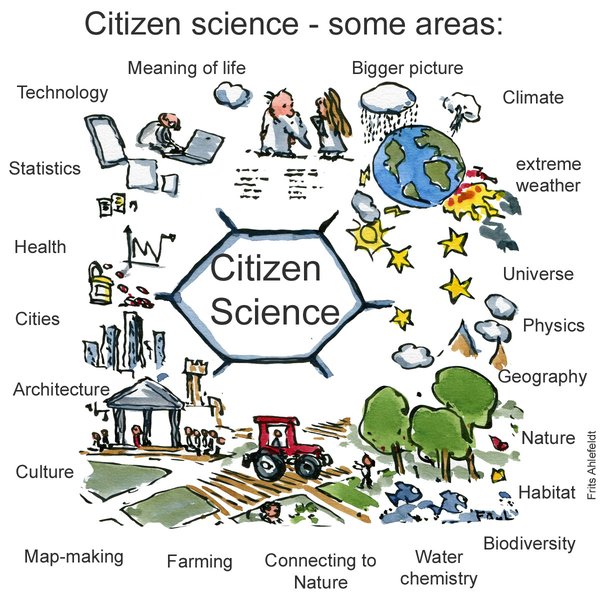
VGI often intersects with diverse Citizen Science domains, leveraging public participation for data collection across fields like ecology, astronomy, and health.
Persistent Challenges and Future Pathways
Despite significant progress, the review identified several challenges and areas requiring further research, many of which remain relevant today:
- Quality Assurance: Developing robust, scalable, and often automated frameworks for VGI quality assessment and control.
- Data Integration: Methodological challenges in effectively integrating VGI with traditional, authoritative geographic datasets.
- Interdisciplinarity: The need for greater collaboration between GIScience, computer science, social sciences, and domain experts.
- Contributor Diversity and Bias: Understanding and mitigating potential demographic, digital, and geographic biases in VGI contributions.
- Ethical Considerations: Addressing issues of privacy, data ownership, and potential misuse of volunteered information.
- Scalability: Developing methods to handle the increasing volume and velocity of VGI data for large-scale applications.
- Research Fragmentation: Addressing the potential for VGI research to become siloed into specialized sub-fields without sufficient cross-communication.
The Enduring Impact of the Review
A Foundational Reference in GIScience
The Yan et al. (2020) paper is widely regarded as a seminal and landmark contribution to the VGI literature. By systematically synthesizing the first ten years of research, it provided a crucial benchmark, mapped the intellectual structure of the field, and consolidated key achievements and challenges. It serves as an essential guidepost for researchers new to VGI and a foundational reference for scholars studying the evolution of geospatial technologies and participatory methods. Its comprehensive scope and structured analysis have made it a frequently cited work in subsequent studies on VGI trends, applications, and methodologies.
VGI Research Beyond the First Decade
The themes and challenges identified in the review continue to resonate in contemporary VGI research. Ongoing work builds upon the foundations laid during the first decade, exploring topics such as:
- The integration of VGI with Artificial Intelligence and Machine Learning for enhanced analysis and quality assessment.
- The evolution of VGI into related concepts like "citizen sensing."
- Continued efforts to improve VGI quality frameworks and integration techniques.
- Addressing the "fragmentation" of the VGI research landscape noted in later commentaries.
- Exploring VGI's role in addressing global challenges like climate change and sustainable development.
Understanding VGI in Action
Citizen Science and VGI Collaboration
Volunteered Geographic Information often operates at the intersection with Citizen Science, where public participation is key to collecting data for scientific research. This video explores the concept of citizen science, highlighting how volunteers contribute to various research areas, including those involving spatial data collection, which is central to VGI. Understanding this connection helps contextualize the 'volunteer' aspect of VGI and its broader implications for participatory research and data generation.
VGI Research Focus Areas (2007-2017)
This table summarizes key research topics investigated within the three overarching themes identified by Yan et al. (2020), providing examples of specific questions and application contexts explored during VGI's first decade.
| Overarching Theme | Key Research Topics / Questions | Example Applications / Platforms |
|---|---|---|
| 1. VGI Contributions & Contributors | Who contributes VGI? What are their motivations? How accurate are contributions? What influences participation levels? How does contributor behaviour vary across platforms? | OpenStreetMap (OSM) contributor analysis, studies on motivations for geotagging photos, quality assessment of specific VGI datasets, demographic surveys of volunteers. |
| 2. Main Fields Applying VGI | How can VGI be used for disaster response? Can VGI update official maps? How is VGI applied in environmental monitoring? What are the benefits/limitations in specific domains? | Crisis mapping platforms (e.g., Ushahidi), VGI for land use/land cover change detection, participatory noise mapping, biodiversity reporting apps, validating transport network data. |
| 3. Conceptions & Envisions | How should VGI quality be defined and measured? How can VGI be integrated with authoritative data? What are the theoretical underpinnings of VGI? What are the ethical challenges? What is the future potential of VGI? | Development of VGI quality indicators, frameworks for data fusion, conceptual models of VGI ecosystems, studies on spatial data uncertainty, discussions on privacy protocols, exploring links to Big Data. |
Frequently Asked Questions (FAQ)
What exactly is Volunteered Geographic Information (VGI)? +
VGI is geographic information (like locations, features on a map, routes, place names, or spatially referenced observations) that is created and shared voluntarily by individuals, often non-experts, typically using web or mobile technologies. Examples include contributing to OpenStreetMap, geotagging photos, or reporting local events via an app.
What time period does the Yan et al. (2020) review cover? +
The review covers the first decade of VGI research, specifically analyzing articles published between November 20, 2007 (shortly after the term VGI was coined) and November 20, 2017.
What were the main research themes identified in the paper? +
The paper identified three overarching themes: (1) VGI contributions and contributors (focusing on the creators and creation process), (2) Main fields applying VGI (exploring application domains like disaster management and urban planning), and (3) Conceptions and envisions (addressing theoretical aspects, methodologies, data quality, and future directions).
What is the significance of data quality in VGI research? +
Data quality is a central and persistent concern in VGI research. Because VGI is often created by non-experts with varying levels of skill and motivation, its accuracy, completeness, and consistency can vary significantly. Much research focuses on developing methods to assess VGI quality, understand factors influencing it, validate volunteered data, and communicate its uncertainty to users effectively. Establishing trust in VGI often hinges on addressing these quality concerns.
How does VGI relate to Citizen Science? +
VGI is closely related to Citizen Science, and there is significant overlap. Citizen Science involves public participation in scientific research, often including data collection. Many VGI initiatives can be considered forms of citizen science where the collected data is geographic in nature. However, not all VGI is explicitly part of a formal scientific project (e.g., mapping personal points of interest), and not all citizen science involves geographic information. Both leverage voluntary contributions from the public.
Recommended Further Exploration
- What are the main challenges in assessing VGI data quality?
- How is VGI used in disaster management and emergency response?
- Compare VGI and authoritative geographic data sources.
- What are the latest trends in VGI research after 2017?
References
Last updated April 30, 2025