
Decoding Ancient Rivers: A Journey Through Fluvial Lithofacies and Assemblages
Uncover the secrets held within river-deposited sediments and learn how geologists reconstruct past environments.
Essential Insights: Key Takeaways
- Fluvial lithofacies are the fundamental descriptive units of rocks deposited by rivers, characterized by specific grain sizes, sedimentary structures, and compositions.
- Lithofacies assemblages are groups of related lithofacies that occur together, representing distinct depositional environments or architectural elements within a fluvial system (e.g., channel fills, floodplains).
- Understanding these concepts is crucial for paleoenvironmental reconstruction, predicting the location and quality of subsurface resources like oil, gas, and groundwater, and advancing our knowledge of Earth's history.
Unveiling Fluvial Lithofacies: The Building Blocks of Ancient Rivers
Fluvial lithofacies are the basic descriptive units of sedimentary rocks that have been deposited in fluvial, or river, environments. They represent the tangible evidence of past river processes, including erosion, transportation, and deposition of sediments. The study of these lithofacies is the cornerstone for any investigation into ancient river systems, providing critical insights into their architecture and the potential quality of any associated reservoirs.
What Exactly Are Fluvial Lithofacies?
A lithofacies is defined by its observable physical, chemical, and biological characteristics. In the context of fluvial systems, these characteristics are a direct result of the river's energy, sediment load, and the prevailing environmental conditions at the time of deposition. Geologists meticulously describe lithofacies based on attributes such as:
- Grain Size: Ranging from fine clays and silts to coarse sands and gravels.
- Sedimentary Structures: Features like cross-bedding, ripple marks, laminations, and scour surfaces, which indicate flow direction and energy.
- Composition: The mineralogy of the sediment grains.
- Color: Can indicate the presence of organic matter or specific minerals.
- Fossil Content: Preserved remains of plants or animals that lived in or near the river.
- Bedding Patterns: The arrangement and thickness of sedimentary layers.
For example, a coarse-grained sandstone with prominent trough cross-bedding would be classified as a distinct lithofacies, suggesting deposition within an active river channel with significant flow energy.
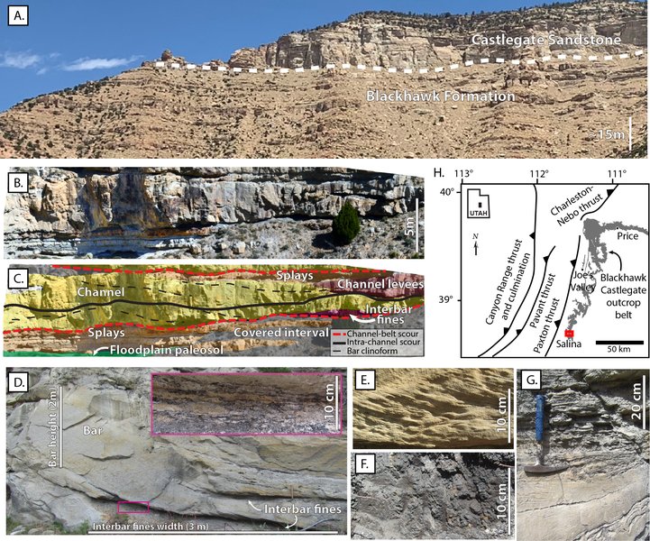
An outcrop illustrating the complex architecture of fluvial deposits, highlighting the interplay of channel sands and floodplain fines. Fine-sediment supply plays a crucial role in controlling this architecture.
Key Characteristics for Identification
The identification and classification of fluvial lithofacies primarily rely on detailed core observations and the analysis of logging data from boreholes, especially in subsurface studies. These methods allow geologists to meticulously document the vertical succession of sedimentary features.
- Channel Deposits: Typically composed of sandstone or conglomerate, these lithofacies often exhibit structures like cross-bedding, ripple marks, and scour surfaces, indicative of deposition within active river channels. An upward-fining trend (coarser sediments at the base, finer towards the top) is common.
- Overbank Deposits: These are finer-grained sediments, such as siltstone, mudstone, or shale, deposited on floodplains during flood events when the river overflows its banks. They may show laminations, root traces (paleosols), or desiccation cracks.
- Point Bar Deposits: Characteristically sandstones displaying lateral accretion surfaces, formed on the inner bends of meandering rivers.
- Crevasse Splay Deposits: Wedge-shaped deposits of sand and silt formed when a river breaches its natural levee during a flood, spreading sediment onto the floodplain.
- Floodplain Mudstones: Clay-rich, often laminated or massive mudstones resulting from the settling of suspended sediment in low-energy floodplain environments, sometimes with evidence of soil formation (paleosols).
Miall's Pioneering Classification
A widely adopted framework for classifying fluvial lithofacies was developed by Andrew D. Miall. His system uses a series of codes to denote specific lithofacies based on grain size, sedimentary structures, and other features. Examples include:
- Gmm: Massive, matrix-supported gravel (often from debris flows).
- St: Trough cross-bedded sandstone.
- Sp: Planar cross-bedded sandstone.
- Sr: Ripple-laminated sandstone.
- Sh: Horizontally laminated sandstone.
- Fl: Laminated fine-grained sediment (siltstone/mudstone).
- Fm: Massive mudstone.
- Fr: Rootleted mudstone (indicating soil formation).
While Miall's scheme provides a standardized vocabulary, it is not exhaustive, and geologists often adapt or expand upon it to suit the specific characteristics of their study area.
Decoding Lithofacies Assemblages: Piecing Together Fluvial Environments
While individual lithofacies provide clues about specific depositional conditions, a **lithofacies assemblage** offers a broader picture. It refers to a characteristic grouping or association of different lithofacies that are found together, both vertically and laterally. These assemblages are interpreted to represent specific sedimentary environments or distinct architectural elements within a larger fluvial system.
From Individual Facies to Environmental Signatures
The arrangement and relationship between different lithofacies in an assemblage reflect the dynamic processes and sub-environments present in the ancient river system. For instance, an assemblage might consist of a basal gravelly channel deposit (lithofacies Gt or Gp), overlain by trough cross-bedded sandstones (St) from migrating dunes within the channel, capped by laminated mudstones (Fl) representing overbank flood deposits. Such a sequence tells a story of changing energy conditions and depositional settings.
The vertical stacking of individual lithofacies according to certain rules, often reflecting cycles of channel activity and abandonment or shifts in depositional style, forms these assemblages. The characteristics of these assemblages can also significantly impact post-depositional processes like diagenesis, influencing reservoir quality. For example, assemblages rich in ductile grains might compact more, while those with high feldspar content could undergo more dissolution.
The Significance of Stacking Patterns
The vertical and lateral relationships of lithofacies within an assemblage are key to understanding:
- Channel Dynamics: How rivers migrated, avulsed (shifted course), or incised.
- Sediment Dispersal Patterns: The pathways and distribution of sediment within the basin.
- Basin Fill Processes: The overall manner in which the sedimentary basin was filled over time.
- Paleoenvironmental Reconstruction: Building a detailed picture of the ancient river's morphology, flow conditions, and surrounding landscape.
An infinite number of vertical lithofacies assemblages can exist, varying depending on geological age, basin setting, climate, proximity to sediment sources, and other local variables. Capturing this variability helps in developing robust facies models that account for the inherent uncertainty in sedimentological interpretations.
A Spectrum of River Deposits: Common Fluvial Lithofacies Types
Fluvial systems deposit a wide array of sediments, leading to diverse lithofacies. These can be broadly categorized based on their dominant grain size and characteristic structures.
Physical & compositional
characteristics of
river-deposited rock units"] id1_2["Key Features"] id1_2_1["Grain Size
(Gravel, Sand, Silt, Clay)"] id1_2_2["Sedimentary Structures
(Cross-bedding, Ripples, Lamination)"] id1_2_3["Composition & Texture"] id1_3["Types"] id1_3_1["Gravel-Dominated
e.g., Gmm (Massive Gravel)
Gt (Trough Cross-bedded Gravel)"] id1_3_2["Sand-Dominated
e.g., St (Trough Cross-bedded Sand)
Sp (Planar Cross-bedded Sand)
Sr (Ripple Laminated Sand)
Sh (Horizontally Laminated Sand)"] id1_3_3["Fine-Grained
e.g., Fl (Laminated Fines)
Fm (Massive Mudstone)
Fr (Rooted Mudstone - Paleosol)"] id2["Lithofacies Assemblages"] id2_1["Definition
Groups of related lithofacies
representing specific fluvial
environments or elements"] id2_2["Significance"] id2_2_1["Paleoenvironmental Reconstruction"] id2_2_2["Understanding Depositional Processes
(Channel Migration, Flooding)"] id2_2_3["Predicting Reservoir Architecture"] id2_3["Common Fluvial Environments"] id2_3_1["Meandering River Systems"] id2_3_2["Braided River Systems"] id2_3_3["Anastomosed River Systems"] id2_3_4["Ephemeral/Arid Systems"]
The mindmap above illustrates the hierarchical relationship between individual fluvial lithofacies, their defining characteristics and types, and how they combine to form lithofacies assemblages indicative of broader fluvial environments and processes.
Gravel-Dominated Lithofacies: High-Energy Channels
These lithofacies, such as massive or crudely bedded conglomerates (Miall's Gmm, Gp, Gt), are indicative of high-energy fluvial environments. They often form in the axial parts of river channels, particularly in braided river systems or proximal parts of alluvial fans, where strong hydrodynamic forces allow for the transport and accumulation of coarse material. They can also result from debris flows.
Sand-Dominated Lithofacies: The Workhorses of River Transport
Sandstones are prevalent in many fluvial deposits and exhibit a variety of sedimentary structures. Common types include:
- Trough cross-bedded sandstone (St): Formed by the migration of 3D dunes in channel environments.
- Planar cross-bedded sandstone (Sp): Represents the migration of 2D dunes or transverse bars.
- Ripple-laminated sandstone (Sr): Indicates lower energy flow conditions, often found on bar tops or in shallower channel areas.
- Horizontally laminated sandstone (Sh): Can form under upper flow regime plane bed conditions or rapid deposition from suspension.
These are characteristic of sand-bedload streams and form various channel and bar elements.
Fine-Grained Lithofacies: Whispers from Floodplains and Quiet Waters
Comprising siltstones, mudstones, and claystones, these lithofacies (e.g., Fl, Fm, Fsc) typically accumulate in lower-energy settings away from the main channel thalweg. These include:
- Overbank deposits: Sediments settled from suspension during floods on the floodplain.
- Levee deposits: Finer sands and silts deposited along channel margins.
- Abandoned channel fills: Fine sediments filling in former active channels, often rich in organic matter.
- Paleosols (Fr): Ancient soils preserved within the sedimentary record, indicated by root traces, soil horizons, and specific soil structures.
Specialized Lithofacies: Unique Environmental Clues
Some lithofacies provide specific insights into fluvial dynamics or associated environments:
- Intraclast conglomerates: Composed of fragments of previously deposited sediment (e.g., mud chips) ripped up and redeposited by strong currents, indicating erosion within the channel.
- Eolian-influenced sands: In arid or semi-arid settings, wind-blown sand can be reworked by fluvial processes or interbedded with fluvial deposits, creating mixed fluvial-eolian lithofacies.
Reading the River's Story: Key Fluvial Lithofacies Assemblages
Lithofacies assemblages are characteristic groupings of lithofacies that together define specific fluvial depositional environments or architectural elements within the river system. They are identified through the analysis of vertical profiles (e.g., from core or outcrop) and lateral associations of lithofacies.
Meandering River Assemblages
These assemblages are typical of high-sinuosity rivers. They often exhibit well-defined fining-upward sequences, reflecting the lateral migration of meander bends. A classic meandering river assemblage might include:
- A basal erosional surface.
- Coarse channel-lag deposits (conglomerate or coarse sandstone).
- Point bar deposits characterized by sandstones with lateral accretion surfaces (epsilon cross-stratification).
- Overlying fine-grained floodplain deposits (siltstones, mudstones, paleosols).
- Associated oxbow lake fills (organic-rich mudstones).
Braided River Assemblages
Braided rivers are characterized by multiple, interwoven channels separated by bars and islands. Their assemblages are often dominated by conglomerates and coarse to medium sandstones with abundant channel features. Key characteristics include:
- Multiple, stacked channel bar deposits.
- Sheet-like channel fills.
- Relatively less abundant floodplain fine sediments compared to meandering systems.
- Cyclic sequences of channel bars (gravelly or sandy) and thinner overbank deposits. Miall's "South Saskatchewan type" is an example, featuring sand-dominated cycles.
Anastomosed River Assemblages
Anastomosed rivers consist of multiple, interconnected channels that are separated by stable, often vegetated, floodplain islands. Their assemblages typically show:
- Distinct, relatively stable channel fills (often sand-dominated).
- Extensive and well-developed fine-grained overbank deposits (siltstones, mudstones, coals if conditions permit peat accumulation).
- Evidence of channel avulsion and crevasse splay development.
Other Notable Assemblages
- Single-thread Channel Assemblages: Represent narrower, often deeper channels with well-defined scour and fill structures, common in smaller perennial rivers with relatively stable banks.
- Avulsion-related Assemblages: Characterized by depositional packages showing evidence of rapid shifts in channel position, often including extensive crevasse splay deposits and widespread floodplain sediments.
- Ephemeral or Arid Fluvial Assemblages: Deposits from rivers that flow intermittently, often showing features like flashy flood deposits, desiccation cracks, and sometimes an admixture of eolian (wind-blown) sediments.
The following chart provides a comparative overview of characteristics often associated with different fluvial system types, which are reflected in their lithofacies assemblages. These are generalizations, and significant variability exists within each type.
This radar chart compares generalized characteristics (scaled 1-5, where 5 is 'High' or 'Coarse' and 1 is 'Low' or 'Fine') across different fluvial depositional systems. For instance, meandering systems typically exhibit high channel stability and floodplain development, while braided systems are characterized by coarser grain sizes and lower channel stability.
The Geologist's Toolkit: Identifying and Interpreting Fluvial Signatures
The identification and interpretation of fluvial lithofacies and their assemblages involve a combination of field observations, laboratory analyses, and subsurface data integration.
Observational Techniques: From Field to Lab
- Outcrop Studies: Direct observation of sedimentary rocks exposed at the Earth's surface allows for detailed logging of lithofacies, measurement of sedimentary structures, and mapping of facies relationships.
- Core Analysis: Examination of cylindrical rock samples (cores) drilled from subsurface formations is crucial for identifying lithofacies in hydrocarbon reservoirs or groundwater aquifers. This involves describing grain size, textures, structures, and mineralogy.
- Well Log Analysis: Geophysical measurements (well logs) taken in boreholes (e.g., gamma-ray, resistivity, sonic logs) can be calibrated with core data to interpret lithofacies types and their vertical distribution between cored intervals.
- Thin Section Petrography: Microscopic examination of thin slices of rock helps to determine mineral composition, grain relationships, porosity, and diagenetic alterations, providing further detail on lithofacies characteristics.
Key Interpretive Features
Geologists look for specific features and patterns when interpreting fluvial deposits:
- Sedimentary Structures: Trough and planar cross-bedding indicate current direction and flow regime; ripple marks suggest water movement; mud drapes can indicate fluctuating flow conditions.
- Grain Size Trends: Fining-upward sequences are common in channel fills (especially point bars), while coarsening-upward sequences might indicate prograding crevasse splays or channel approaches.
- Vertical Stacking Patterns: The repetitive succession of certain lithofacies or assemblages can indicate cyclic processes like channel migration, avulsion, or changes in sediment supply/accommodation space.
- Spatial Distribution: Channel deposits are typically more laterally restricted (lenticular or ribbon-like) but can be vertically stacked, while floodplain fines are generally more laterally extensive (sheet-like).
- Bounding Surfaces: Erosional surfaces often mark the base of channels, while flooding surfaces can separate channel complexes from overlying marine or lacustrine deposits.
The following table summarizes some common fluvial lithofacies, their typical depositional environments, and key descriptive features:
| Lithofacies Code (Miall example) | General Lithofacies Type | Depositional Environment/Element | Typical Features |
|---|---|---|---|
| Gms, Gmm | Matrix-supported Gravel | Debris flows, proximal high-energy channels | Poorly sorted gravel in a finer matrix, often massive |
| Gt, Gp | Clast-supported Gravel | High-energy channel bedforms (gravel bars, channel lags) | Organized gravels, may show crude cross-bedding |
| St | Trough Cross-bedded Sandstone | Channel fills (migrating 3D dunes) | Curved, scoop-shaped cross-beds; medium to coarse sand |
| Sp | Planar Cross-bedded Sandstone | Channel fills (migrating 2D dunes, transverse bars) | Tabular, planar cross-beds; medium to coarse sand |
| Sr | Ripple-laminated Sandstone | Lower energy channel margins, bar tops, levee crests | Small-scale cross-lamination (ripples); fine to medium sand |
| Sh | Horizontally Laminated Sandstone | Upper flow regime plane beds, rapid deposition from suspension | Parallel laminations; fine to coarse sand |
| Sl | Low-angle Cross-bedded Sandstone | Point bars, some longitudinal bars | Gently dipping cross-beds; sand |
| Fl | Laminated Siltstone/Mudstone | Overbank floodplain, abandoned channels, levee backslopes | Fine laminations, often reflects quiet water deposition |
| Fm | Massive Mudstone | Floodplain, suspension settling, bioturbation | Lack of distinct lamination, may be bioturbated |
| Fr | Rootleted Mudstone/Sandstone (Paleosol) | Vegetated floodplain, stable interfluves | Presence of root traces, soil horizons, pedogenic structures |
| C | Coal / Carbonaceous Shale | Swamps, mires on floodplains or in abandoned channels | Organic-rich layers, plant debris |
This table provides a snapshot of common lithofacies. Actual fluvial sequences often show complex interbedding and transitions between these types, reflecting the highly dynamic nature of river systems.
Why Fluvial Lithofacies Matter: Applications and Significance
The study of fluvial lithofacies and their assemblages has profound implications across various fields of geology and resource exploration.
Reconstructing Ancient Landscapes and Climates
Fluvial deposits are archives of Earth's past. By analyzing lithofacies assemblages, geologists can reconstruct ancient river morphologies (meandering, braided, etc.), infer past flow conditions, estimate sediment discharge, and understand the influence of climate (e.g., arid vs. humid) and tectonic settings on river systems. Paleosols within fluvial sequences provide direct evidence of past terrestrial conditions and atmospheric CO2 levels.
Unlocking Subsurface Resources: Hydrocarbons and Groundwater
Fluvial sandstones, particularly those deposited in channel environments, often form excellent reservoirs for oil, natural gas, and groundwater due to their typically good porosity and permeability.
- Petroleum Geology: Recognizing channel sandstone assemblages (e.g., point bars, braided channel fills) helps predict reservoir distribution, geometry, connectivity, and quality. The internal architecture of these sand bodies, dictated by their lithofacies, controls fluid flow pathways.
- Hydrogeology: Fluvial facies architecture similarly controls the characteristics of groundwater aquifers, influencing storage capacity and flow rates. Understanding the distribution of permeable channel sands versus impermeable floodplain muds is critical for water resource management.
Advancing Stratigraphic Understanding
Fluvial lithofacies and assemblages are key components in sequence stratigraphy, a methodology used to understand the large-scale arrangement of sedimentary rocks. Identifying lithofacies boundaries and key surfaces (e.g., flooding surfaces, sequence boundaries) within fluvial successions helps in correlating rock units across basins and interpreting basin evolution in response to sea-level changes, tectonics, and sediment supply.
This video by GEO GIRL provides an overview of fluvial depositional environments, processes, sedimentary structures, and stratigraphy, offering a visual complement to understanding how fluvial lithofacies and assemblages are formed and interpreted.
Factors Sculpting Fluvial Diversity
The types and arrangements of fluvial lithofacies and assemblages are not random; they are controlled by a complex interplay of external and internal factors.
The Role of Climate, Tectonics, and Sediment Supply
- Climate: Influences weathering rates (sediment production), vegetation cover (bank stability, organic input), and discharge regime (perennial, ephemeral, flood magnitude/frequency). Arid climates may lead to ephemeral river systems with different facies characteristics compared to humid-region perennial rivers.
- Tectonics: Controls basin subsidence (accommodation space for sediment accumulation), uplift rates in source areas (sediment supply and caliber), and overall basin gradient, which affects river energy and style.
- Sediment Supply: The volume, grain size, and composition of sediment delivered to the fluvial system directly impact the resulting lithofacies. Source rock lithology plays a major role here.
- Base Level: Changes in sea level (for rivers reaching the coast) or local base levels (e.g., lakes) affect river gradients and depositional patterns.
- Discharge Regime: The variability and magnitude of water flow significantly influence sediment transport capacity and the types of bedforms and sedimentary structures developed.
The interplay of these factors means that even within a single overarching river type (e.g., braided), considerable variability in lithofacies assemblages can be observed globally and throughout geological time.
Evolving Perspectives: Modern Approaches and Research Frontiers
The study of fluvial sedimentology continues to evolve, with new tools and conceptual models enhancing our ability to interpret these complex systems.
Digital Innovations in Facies Analysis
- Quantitative Facies Analysis: Moving beyond purely descriptive approaches, researchers use statistical methods and databases to quantify lithofacies proportions and associations, leading to more objective environmental interpretations.
- Digital Facies Modeling: Sophisticated computer software allows for the creation of 3D geological models of fluvial reservoirs, integrating core, log, and seismic data to predict the distribution and connectivity of sand bodies.
- Machine Learning and AI: Artificial intelligence algorithms are increasingly being applied to automate lithofacies identification from well log data or seismic attributes, improving efficiency and consistency in subsurface characterization.
- Knowledge Graphs: Construction of fluvial facies knowledge graphs helps in organizing and linking vast amounts of sedimentological information, aiding in predictive geoscience and hypothesis testing.
- Integration with Geomorphology: Modern research increasingly emphasizes dynamic river planforms, incorporating quantitative geomorphological data from modern rivers and remote sensing to refine facies models and better understand the processes shaping fluvial architecture.
These advancements, coupled with ongoing field studies of both modern rivers and ancient deposits, continue to deepen our understanding of fluvial lithofacies and assemblages, improving our ability to read the rich geological history recorded in river sediments.
Frequently Asked Questions
What is the main difference between a fluvial lithofacies and a lithofacies assemblage?
A fluvial lithofacies is a distinct body of sedimentary rock deposited by a river, characterized by its specific physical attributes like grain size, sedimentary structures, and composition (e.g., a trough cross-bedded sandstone). A lithofacies assemblage, on the other hand, is a group or association of several related lithofacies that consistently occur together and are interpreted as representing a particular depositional environment or element within the fluvial system (e.g., a point bar assemblage consisting of a basal lag, overlying cross-bedded sands, and capped by ripple-laminated sands).
Why is Miall's classification system for fluvial lithofacies important?
Andrew Miall's classification system provides a standardized alphanumeric code for describing common fluvial lithofacies based on their texture and sedimentary structures. This system is important because it offers a common language for geologists worldwide to describe and compare fluvial deposits from different locations and geological ages. It facilitates consistent data collection and aids in the development and application of fluvial facies models.
How do fluvial lithofacies help in hydrocarbon exploration?
Fluvial sandstones, particularly those forming channel fills and bars (e.g., point bars, braided channel sands), often possess good porosity and permeability, making them excellent hydrocarbon reservoirs. Identifying specific fluvial lithofacies and their assemblages from core and well log data helps geologists to:
- Predict the geometry (shape and extent) of potential reservoir sand bodies.
- Understand the internal architecture and connectivity of these sand bodies, which controls fluid flow.
- Estimate reservoir quality (porosity and permeability).
- Develop more accurate geological models for exploration and production strategies.
Can the same lithofacies be found in different fluvial assemblages?
Yes, a specific lithofacies type (e.g., trough cross-bedded sandstone - St) can be found in various fluvial assemblages. For instance, St can be a component of a braided river channel assemblage, a meandering river point bar assemblage, or even a crevasse splay deposit. It is the association of multiple lithofacies, their proportions, and their vertical and lateral relationships (i.e., the assemblage) that helps to distinguish the overall depositional environment, rather than a single lithofacies in isolation.
Recommended Further Exploration
- How are fluvial facies models utilized in the search for oil and gas?
- What are the key differences in sedimentary structures observed between meandering and braided river deposits?
- How does climate change influence the types of fluvial lithofacies that are preserved in the geological record?
- Could you explain the concept of architectural elements within the field of fluvial sedimentology?
References
Last updated May 7, 2025