
The Role of Spatial Epidemiology in Today's World
Understanding Health Through the Lens of Geography and Data
Key Takeaways
- Disease Mapping and Real-Time Surveillance: Spatial epidemiology provides essential tools for visualizing and tracking disease patterns, enabling timely public health responses.
- Integration of Advanced Technologies: The utilization of GIS, AI, and big data analytics enhances the accuracy and scope of epidemiological studies, facilitating more effective interventions.
- Enhancing Health Equity and Policy Making: By identifying disparities in health outcomes and resource distribution, spatial epidemiology informs policies aimed at achieving equitable healthcare access.
Introduction
Spatial epidemiology is an interdisciplinary field that merges principles from geography, statistics, and public health to study the distribution and determinants of diseases within specific geographic contexts. In an era marked by globalization, climate change, and technological advancements, spatial epidemiology has become indispensable in addressing contemporary health challenges. This comprehensive overview outlines the multifaceted roles that spatial epidemiology plays in today's world, emphasizing its impact on disease surveillance, public health interventions, policy making, and health equity.
Disease Mapping and Surveillance
Visualizing and Tracking Disease Patterns
One of the foundational roles of spatial epidemiology is the mapping and surveillance of diseases. By creating visual representations of disease incidence and prevalence across different geographic regions, public health officials can identify hotspots, detect emerging outbreaks, and monitor trends over time.
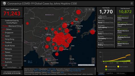
Tools such as Geographic Information Systems (GIS) and spatial statistics are pivotal in this process. For instance, during the COVID-19 pandemic, spatial epidemiology enabled the real-time tracking of infection rates, facilitating timely interventions and resource allocation. Similarly, the surveillance of vector-borne diseases like malaria and dengue fever relies heavily on spatial data to predict and mitigate outbreaks.
Moreover, disease mapping aids in the implementation of early warning systems. By analyzing spatial patterns, researchers can anticipate potential disease outbreaks before they escalate, allowing for proactive measures to contain their spread.
Identifying and Analyzing Risk Factors
Environmental, Socioeconomic, and Behavioral Determinants
Understanding the factors that contribute to disease distribution is crucial for effective public health strategies. Spatial epidemiology examines the relationship between health outcomes and various risk factors, including environmental, socioeconomic, and behavioral determinants.
Environmental factors such as air pollution, water quality, and climate change significantly influence the prevalence of diseases. For example, areas with high levels of air pollution may experience higher rates of respiratory illnesses. Similarly, regions prone to flooding or natural disasters may see increased incidences of waterborne diseases.
Socioeconomic conditions, including poverty, education levels, and access to healthcare, also play a critical role in health disparities. Spatial analysis can highlight communities that are underserved or at higher risk due to inadequate healthcare infrastructure or economic challenges.
Behavioral patterns, such as smoking rates or physical activity levels, are additional factors that spatial epidemiology considers. By mapping these behaviors, public health officials can design targeted interventions aimed at mitigating associated health risks.
Informing Public Health Interventions and Decision-Making
Data-Driven Strategies for Effective Health Management
Spatial epidemiology provides the evidence base for designing and implementing public health interventions. By identifying high-risk areas and understanding the underlying factors contributing to disease spread, health authorities can allocate resources more effectively and tailor interventions to the specific needs of communities.
For example, during an influenza outbreak, spatial data can inform the distribution of vaccines to areas with higher infection rates. Similarly, in chronic disease management, mapping can reveal regions with elevated rates of diabetes or cardiovascular diseases, prompting the establishment of specialized healthcare facilities or wellness programs in those areas.
Furthermore, spatial epidemiology supports policy making by offering insights into the effectiveness of existing health programs and identifying gaps that need to be addressed. This ensures that public health policies are grounded in robust data, enhancing their impact and sustainability.
Integration with Advanced Technologies
Leveraging GIS, AI, and Big Data for Enhanced Analysis
The evolution of technology has significantly augmented the capabilities of spatial epidemiology. Geographic Information Systems (GIS) enable the integration and analysis of spatial data, while artificial intelligence (AI) and big data analytics enhance the precision and scalability of epidemiological models.
AI algorithms can process vast amounts of data to identify complex patterns and predict disease outbreaks with greater accuracy. For instance, machine learning models can analyze environmental data, population movement patterns, and historical disease incidence to forecast future epidemics.
Big data sources, including electronic health records, social media, and satellite imagery, provide comprehensive datasets that enrich spatial analyses. The combination of these technologies allows for real-time monitoring and more dynamic responses to emerging health threats.
Health Equity and Access to Care
Addressing Disparities Through Spatial Insights
Health equity is a paramount concern in public health, and spatial epidemiology plays a critical role in identifying and addressing disparities in health outcomes and healthcare access. By mapping healthcare resources alongside disease burden, spatial analyses can reveal regions where populations are underserved.
This information is instrumental in guiding policies aimed at reducing inequities. For example, identifying areas with limited access to healthcare facilities allows for the strategic placement of new clinics or the deployment of mobile health units to reach vulnerable populations.
Moreover, spatial epidemiology highlights the intersectionality of various determinants of health, such as socioeconomic status, race, and geographic location. Understanding these intersections enables more nuanced and effective interventions that address the root causes of health disparities.
Predicting and Managing Disease Spread
Proactive Measures Through Spatial Modeling
Predictive modeling is a key aspect of spatial epidemiology, enabling the anticipation of disease spread based on various factors such as population density, movement patterns, and environmental conditions. Advanced spatial models can simulate scenarios of disease transmission, providing valuable foresight for public health planning.
During infectious disease outbreaks, such as the recent COVID-19 pandemic, spatial epidemiology has been instrumental in predicting hotspots and evaluating the potential impact of intervention strategies. By simulating different scenarios, health authorities can make informed decisions about implementing lockdowns, travel restrictions, and vaccination campaigns.
Additionally, spatial modeling aids in managing ongoing disease outbreaks by continuously updating predictions based on real-time data. This dynamic approach ensures that public health responses remain effective as circumstances evolve.
Environmental Health Studies
Assessing the Impact of Environmental Factors on Health
Environmental health is intrinsically linked to spatial epidemiology, as geographic factors such as climate, pollution, and natural disasters significantly influence public health outcomes. Spatial analyses explore these connections, enabling a deeper understanding of how environmental conditions affect disease prevalence and severity.
For instance, studies on air quality can correlate pollution levels with respiratory diseases, while research on water quality assesses the incidence of waterborne illnesses in contaminated regions. Furthermore, spatial epidemiology examines the effects of climate change on vector-borne diseases, predicting shifts in disease distribution as temperatures and weather patterns change.
By elucidating the relationship between environmental factors and health, spatial epidemiology informs strategies aimed at mitigating environmental risks and promoting healthier ecosystems.
Policy and Resource Allocation
Guiding Effective Health Policies Through Spatial Data
Effective policy making relies on accurate and comprehensive data, and spatial epidemiology provides the necessary insights to inform health policies and allocate resources efficiently. By identifying areas with high disease burdens or inadequate healthcare infrastructure, policymakers can prioritize interventions where they are most needed.
For example, spatial data can guide the distribution of vaccines during a pandemic, ensuring that regions with the highest infection rates receive adequate supplies. Similarly, in chronic disease management, spatial analyses can inform the placement of specialized healthcare facilities in areas with elevated prevalence of conditions like diabetes or hypertension.
Moreover, spatial epidemiology supports the evaluation of existing health policies by tracking their impact across different regions. This feedback mechanism allows for the continuous improvement of policies, ensuring they remain relevant and effective in addressing public health challenges.
Population Health Management
Targeting At-Risk Populations for Improved Health Outcomes
Population health management involves monitoring and addressing the health needs of specific groups, and spatial epidemiology provides the tools to identify and manage at-risk populations effectively. By analyzing spatial data, health professionals can pinpoint communities with higher risk factors and tailor interventions to their specific needs.
This targeted approach enhances the effectiveness of health programs, ensuring that resources are utilized where they can have the greatest impact. For instance, identifying regions with limited access to healthcare can lead to the establishment of mobile clinics or telemedicine services to reach these populations.
Additionally, spatial epidemiology assists in tracking the movement and health impacts of populations, particularly in areas experiencing rapid urbanization or migration. Understanding these dynamics is essential for maintaining public health standards and preventing the spread of diseases in densely populated or transient communities.
Disaster Response and Preparedness
Assessing Health Risks and Coordinating Recovery Efforts
In the face of natural disasters or humanitarian crises, spatial epidemiology plays a crucial role in assessing health risks, coordinating disaster response, and planning recovery efforts. By mapping affected areas and analyzing the spatial distribution of health indicators, emergency responders can prioritize areas in need of immediate assistance.
For example, after a hurricane, spatial analyses can identify regions with compromised infrastructure, population displacement, and increased risk of disease outbreaks due to contaminated water sources. This information guides the deployment of medical supplies, vaccination campaigns, and temporary healthcare facilities.
Moreover, spatial epidemiology contributes to long-term preparedness by identifying vulnerabilities and informing the development of resilient healthcare systems capable of withstanding future disasters.
Global Health Security
Monitoring and Mitigating Cross-Border Health Threats
Globalization has interconnected populations worldwide, making the monitoring and mitigation of cross-border health threats more important than ever. Spatial epidemiology contributes to global health security by tracking the movement of diseases across regions and facilitating international collaborations to combat health crises.
Through the analysis of global spatial data, epidemiologists can detect emerging health threats and coordinate responses with international organizations. This collaborative approach was evident during the COVID-19 pandemic, where spatial epidemiology supported global surveillance efforts and informed international travel advisories and containment strategies.
Additionally, spatial epidemiology aids in the allocation of global health resources, ensuring that countries with limited healthcare infrastructure receive the necessary support to manage and control disease outbreaks.
Chronic Disease Research
Exploring Geographic Disparities in Long-Term Health Conditions
While infectious diseases are a significant concern, chronic diseases such as diabetes, cardiovascular diseases, and cancer also pose substantial public health challenges. Spatial epidemiology is instrumental in researching the geographic disparities in the prevalence and management of chronic diseases.
By mapping the incidence of chronic conditions, researchers can identify regions with higher prevalence rates and investigate the contributing factors, such as lifestyle behaviors, environmental exposures, and healthcare access. This information is essential for designing targeted interventions and allocating resources to areas with the greatest need.
Furthermore, spatial analyses can track the effectiveness of chronic disease prevention programs over time, providing valuable feedback for policy adjustment and program improvement.
Conclusion
Spatial epidemiology is a vital component of modern public health, providing the tools and insights necessary to understand and address the complex interplay between geography, environment, and health. Its applications range from disease mapping and surveillance to informing public health interventions, policy making, and advancing health equity. The integration of advanced technologies like GIS, AI, and big data analytics has further empowered spatial epidemiologists to conduct more precise and comprehensive analyses, enhancing the field's capacity to respond to both current and emerging health challenges.
As the world continues to grapple with globalization, climate change, and evolving health threats, the role of spatial epidemiology will only become more pronounced. By leveraging spatial data and technological advancements, public health professionals can develop more effective strategies to prevent and control diseases, ultimately improving health outcomes on a global scale.
References
Last updated January 17, 2025