
Unveiling the Ancient Landscapes of the Stø Formation
A Journey Through Time: Reconstructing the Paleogeography of a Vital Hydrocarbon Reservoir
The Stø Formation, a cornerstone of petroleum exploration in the Norwegian Barents Sea, holds a rich geological history that significantly impacts its current reservoir quality. Understanding its paleogeography—the ancient geography of Earth's surface—is crucial for comprehending its depositional environments, sediment distribution, and overall hydrocarbon potential. This exploration delves into the various facets of the Stø Formation's past, from its depositional settings to the tectonic forces that shaped its evolution.
Key Insights into Stø Formation Paleogeography
- Shallow Marine to Inner Shelf Deposition: The Stø Formation primarily consists of shallow marine to inner shelf deposits, reflecting an overall transgressive period during its formation. This environment was conducive to the deposition of clean, well-sorted sandstones, which are crucial for reservoir quality.
- Early to Middle Jurassic Age: Dating from the Toarcian to Bajocian stages (Early to Middle Jurassic), the Stø Formation was laid down in an epicontinental sea in northern Pangea. This timing places its formation within a period of significant global tectonic and environmental changes.
- Commercially Important Reservoir: Recognized as the most commercially important sandstone reservoir in the Barents Sea, the Stø Formation's paleogeographic context directly influences its reservoir properties, including porosity and permeability, which are critical for hydrocarbon accumulation.
Decoding Paleogeography: The Science of Ancient Landscapes
What is Paleogeography and Why is it Important?
Paleogeography is a fascinating subdiscipline within the geosciences that meticulously reconstructs the physical and biological geography of Earth's ancient past. This includes mapping the configuration and latitudinal distribution of continents, their topographic relief, and the prevailing climates and biota of specific geological periods. By studying the rock and fossil record, geologists can trace past geographic changes and create paleogeographic maps that illustrate continental movements, and the evolution of mountains, lowlands, shallow seas, and deep ocean basins.
The primary goals of paleogeography include mapping the past positions of continents and understanding the processes of erosion, deposition, and sedimentation that influenced ancient landscapes. For instance, sedimentary rocks, like limestone, often host fossils because their formation processes can preserve biological material. Stratigraphic layers act as a timeline through Earth's history, with each layer preserving crucial data about paleoenvironments. Understanding the composition and sequence of these layers, including unconformities (boundaries between rock layers), is essential for reconstructing past geographical settings. These insights are vital for industries such as petroleum exploration, where understanding the ancient depositional environments helps predict the location and quality of hydrocarbon reserves.
The Stø Formation: A Geological Profile
Chronostratigraphy and Lithology
The Stø Formation is recognized as an Early to Middle Jurassic geological unit, specifically spanning the Toarcian to Bajocian stages. This period is significant in Earth's history, characterized by evolving continental configurations and marine environments. The formation primarily consists of mineralogically mature and well-sorted sandstones, dominated by very fine-to medium-grained quartz arenites, with occasional coarse-grained sandstone layers. Feldspathic and quartz wackes are also present, indicating variations in sediment composition and provenance. The presence of shale content, which generally increases in the lower parts of the Stø Formation, suggests fluctuating depositional energy and sediment input.
Depositional Environment: A Shallow Marine Realm
The Stø Formation was deposited in a relatively shallow (tens of meters deep) epicontinental sea located in northern Pangea. This shallow marine to inner shelf setting is characterized by an overall transgressive depositional environment, meaning the sea level was generally rising, leading to the accumulation of marine sediments over previously exposed or near-shore areas. The depositional history of the Stø Formation has been described in terms of six distinct facies associations, ranging from inner shelf to shallow marine environments, indicating a dynamic interplay of currents, waves, and sediment transport. These settings were conducive to the extensive reworking of clean sand, contributing to the formation's excellent reservoir quality.
An illustrative cross-section depicting the sedimentary layers, including the Stø Formation.
Geographic Extent and Thickness
The Stø Formation is widely distributed across most of the Norwegian Barents Sea, making it a prominent target for petroleum exploration. Its thickness varies, with the formation being thickest in southwestern wells and generally thinning eastwards. This pattern corresponds to that of the underlying Nordmela Formation, suggesting a consistent regional geological influence on sediment accumulation. The entire Stø unit can be divided into three distinct depositional sequences, with their bases defined by transgressive episodes. Notably, the basal sequence is predominantly found in the western parts of the Hammerfest Basin, indicating regional variations in its initial depositional stages.
The Hammerfest Basin: A Key Geological Province
Context of the Stø Formation
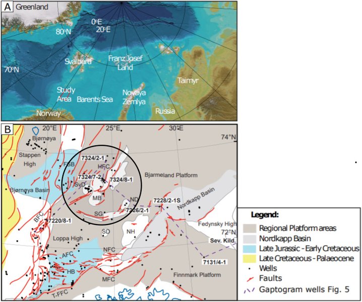
The Hammerfest Basin, located approximately 140 km northwest of Hammerfest, Norway, serves as a crucial geological province for the Stø Formation. This area has a long and complex history of multiple rift phases throughout Late Paleozoic and Mesozoic times, resulting in a landscape characterized by diverse geological features such as basins and highs. The Stø Formation within the Hammerfest Basin is expected to represent continuous reservoirs, deposited in a lower to upper shoreface environment. The Albatross discovery, situated in the central part of the Hammerfest Basin, further highlights the region's significance for hydrocarbon exploration.
The interplay of tectonic forces, including compaction and exhumation, has profoundly affected the reservoir properties of the Stø Formation sandstones in this region. Studies involving wells from the Hammerfest Basin, as well as the Ringvassøy-Loppa Fault Complex and the Troms-Finnmark Fault Complex, have investigated these effects on porosity, permeability, and seismic properties. The Stø Formation is unconformably succeeded by the Fuglen Formation, which also varies in thickness across the region, further demonstrating the complex stratigraphic architecture of the Barents Sea.
Understanding Reservoir Quality and Hydrocarbon Potential
Porosity, Permeability, and Preservation
The Stø Formation is a vital reservoir interval in the Norwegian Barents Sea due to its favorable porosity and permeability values. The sandstones generally exhibit very fine to medium grain sizes, with some coarse-grained layers, contributing to varying reservoir characteristics. However, the reservoir quality can be significantly impacted by post-depositional burial and the detrimental effects of quartz cementation. In deeply buried intervals, illitic clay coatings have been observed to play a crucial role in preserving high porosities by limiting the amount of authigenic quartz overgrowth. This clay coating inhibits quartz nucleation on detrital grains, thereby maintaining pore space necessary for hydrocarbon accumulation.
For example, core plug data from well 7219/8-2 in the Southwestern Barents Sea reveal abnormally high porosity and permeability in certain deeply buried units of the Stø Formation where illitic clay coating is prevalent. The amount of quartz cement is inversely proportional to porosity, underscoring the importance of these natural porosity-preserving mechanisms. The mature mineralogy of the Stø Formation has also been linked to leaching and reworking of sediments prior to final deposition, further influencing its reservoir properties. The post-stack seismic inversion studies within the Snøhvit Gas Condensate Field show low impedance within the Stø Formation reservoir zone, indicating favorable conditions for hydrocarbon presence.
Paleogeographic and Depositional Insights via Radar Chart
Analyzing Key Attributes of the Stø Formation
To further illustrate the multifaceted nature of the Stø Formation's paleogeography and reservoir characteristics, the radar chart below provides a visual comparison of several key attributes. These attributes collectively paint a picture of the formation's geological and commercial significance, reflecting its depositional environment, reservoir quality, and exploration potential.
This radar chart provides a visual representation of how the Stø Formation's characteristics compare to those of a typical marine sandstone reservoir. The 'Reservoir Potential' and 'Geographic Extent' scores highlight the Stø Formation's significant commercial importance and widespread presence. 'Sediment Maturity' and 'Porosity Preservation' reflect its high-quality composition and the geological processes that maintained its excellent reservoir properties, such as illitic clay coatings. 'Depositional Complexity' indicates the varied environments within which it formed, from shallow marine to inner shelf. Lastly, 'Tectonic Influence' acknowledges the complex geological history, including rift phases, compaction, and exhumation, that shaped its current state.
Comparative Stratigraphy and Geological History
The Stø Formation in Context with Other Units
The Stø Formation is not an isolated geological entity; it is part of a broader stratigraphic sequence in the Norwegian Barents Sea. It overlies the Lower Jurassic Nordmela Formation and is in turn overlain by the Middle Jurassic Fuglen and Hekkingen formations. This sequential layering provides a chronological framework for understanding the region's geological evolution. The similar thinning patterns observed in both the Stø and underlying Nordmela formations towards the east suggest a shared depositional history and response to regional tectonic influences.
Both the Stø and Nordmela formations are crucial sandstone units, though the latter generally exhibits higher shale content in its lower parts. The Fruholmen Formation is another proven reservoir in the Norwegian Barents Sea, often found in the Hoop Area alongside the Stø and Nordmela formations. The presence of these interconnected reservoir units underscores the region's hydrocarbon prospectivity and the need for comprehensive stratigraphic studies to understand their interrelationships and individual characteristics.
| Formation Name | Geological Age | Primary Lithology | Depositional Environment | Key Characteristics/Significance |
|---|---|---|---|---|
| Stø Formation | Early to Middle Jurassic (Toarcian-Bajocian) | Fine-to medium-grained quartz arenites, some coarse-grained sandstone, shale | Shallow marine to inner shelf, prograding shoreface | Most commercially important sandstone reservoir in Barents Sea; porosity preservation by illitic clay coatings. |
| Nordmela Formation | Lower Jurassic | Sandstone with increasing shale content downwards | Likely similar to Stø, underlying it | Underlies Stø Formation, shares similar thinning patterns, also a proven reservoir. |
| Fruholmen Formation | Proven reservoir | Sandstone | Proven reservoir | Proven reservoir in the Hoop Area alongside Stø and Nordmela. |
| Fuglen Formation | Middle Jurassic | Varies, overlies Stø | Varies, overlies Stø | Unconformably succeeds Stø Formation, varying thickness across the region. |
Comparison of Stø Formation with related geological units in the Barents Sea.
Ancient Maps and Paleogeographic Reconstructions
The Evolution of Cartography and Earth's Past
The concept of mapping has evolved significantly throughout history, from early cave paintings depicting local terrain to sophisticated modern paleogeographic maps. While ancient maps focused on the known world for navigation and administrative purposes, their fundamental principles laid the groundwork for later geological mapping. Ancient Babylonians used accurate surveying techniques for land plots, and the Greeks, notably Eratosthenes and Ptolemy, developed systems of parallels and meridians that were revolutionary for their time. These early cartographic endeavors, though not focused on geological formations, demonstrate humanity's long-standing desire to represent and understand their environment.
This video discusses the historical context of early world maps, providing insight into how ancient civilizations conceptualized and depicted their known world. While not directly about paleogeography of specific rock formations, it highlights the foundational human efforts in cartography that underpin modern geological mapping techniques.
Modern paleogeography, however, goes far beyond simply charting landmasses. It integrates diverse geological data, including paleomagnetic studies, faunal provincialism, and pre-break-up magmatism, to reconstruct paleocontinental maps. These maps serve as the basis for paleoclimatic modeling, incorporating elements of oceanic and atmospheric circulation to understand their interactive relationship with landmasses. The study of the Stø Formation's paleogeography relies on such advanced techniques to accurately depict its ancient depositional environment and the broader geological context of the Norwegian Barents Sea during the Jurassic period.
Frequently Asked Questions about the Stø Formation
What is the Stø Formation?
Where is the Stø Formation located?
What is the depositional environment of the Stø Formation?
Why is the Stø Formation important for petroleum exploration?
How does paleogeography help understand the Stø Formation?
Conclusion: A Window into Ancient Earth
The Stø Formation stands as a testament to the dynamic geological history of the Norwegian Barents Sea. Its paleogeography, shaped by early to Middle Jurassic shallow marine and inner shelf deposition, combined with complex tectonic phases, has resulted in a highly prospective hydrocarbon reservoir. The interplay of sediment characteristics, such as the mineralogical maturity of its quartz arenites, and post-depositional processes like porosity-preserving illitic clay coatings, are critical to its commercial importance. By diligently reconstructing its ancient landscapes, geoscientists continue to unlock the secrets held within this vital formation, furthering our understanding of Earth's past and securing future energy resources.
Recommended Further Exploration
- Explore the comprehensive geological history of the Barents Sea as a hydrocarbon province.
- Understand how diagenetic processes influence the quality of sandstone reservoirs.
- Delve into the sequence stratigraphic framework of Jurassic formations in the Norwegian Sea.
- Discover the various techniques utilized for paleogeographic reconstruction in the field of petroleum geology.
References
Last updated May 21, 2025