
The Walkability of Utrecht: An In-Depth Analysis
Exploring Utrecht's Exceptional Pedestrian-Friendly Urban Landscape
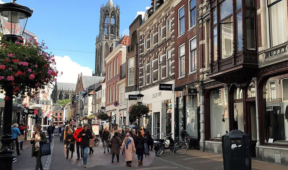
Key Takeaways
- Comprehensive Urban Design: Utrecht's compact city layout and pedestrian-centric infrastructure create an environment where walking is both safe and convenient.
- Integrated Transportation Systems: Seamless integration of public transportation and cycling infrastructure enhances overall mobility and supports walkability.
- Commitment to Sustainability and Community: Utrecht's policies and cultural attitudes prioritize sustainability, health, and social cohesion, reinforcing its status as a walkable city.
Introduction
Utrecht, the vibrant heart of the Netherlands, stands as a paragon of urban walkability. Renowned for its rich historical heritage, innovative urban planning, and sustainable initiatives, Utrecht offers a pedestrian-friendly environment that seamlessly blends the old with the new. This comprehensive analysis delves into the multifaceted aspects that make Utrecht exceptionally walkable, examining urban design, transportation integration, cycling and walking synergy, green spaces, cultural policies, empirical evidence, and future directions.
Urban Design and Infrastructure
Compact City Planning
Utrecht’s urban form is characterized by its compactness, ensuring that essential amenities are within easy walking distance. The city’s layout promotes high accessibility, reducing the need for long commutes and fostering a vibrant street life. This compactness is achieved through:
- Mixed-Use Development: Residential, commercial, and recreational spaces coexist within the same neighborhoods, enabling daily activities to be conducted on foot.
- Dense Street Networks: A grid-like pattern in central areas facilitates multiple route options for pedestrians, enhancing connectivity and ease of navigation.
- Historical Preservation: Preservation of historical streets and canals maintains narrow, pedestrian-friendly pathways that are both charming and functional.
Pedestrian-Friendly Streetscapes
Utrecht’s streets are meticulously designed to prioritize pedestrians. Key features include:
- Wide, Well-Paved Sidewalks: Spacious sidewalks free from obstructions provide comfort and safety for walkers.
- Pedestrian Crossings: Clearly marked crossings with adequate crossing times enhance safety and facilitate smooth pedestrian movement.
- Traffic-Calming Measures: Reduced speed limits, raised crosswalks, and varied paving patterns naturally slow vehicular traffic, creating a safer environment for pedestrians.
- Green Streetscapes: Integration of trees and greenery along walkways not only beautifies the city but also mitigates urban heat island effects, making walking more pleasant.
Car-Free Zones
A significant portion of Utrecht’s city center is designated as car-free zones, fostering a safe and serene environment for pedestrians. Notable examples include:
- Oudegracht (Old Canal): This iconic area is lined with shops, cafes, and restaurants, all accessible on foot, enhancing the pedestrian experience.
- Catharijnesingel: Transformed from a motorized road into a pedestrian-dominant boulevard, this area now features canals, parks, and walking paths that attract both locals and visitors.
Integrated Transportation System
Seamless Transit Hubs
Utrecht’s public transportation infrastructure is seamlessly integrated with its pedestrian zones, ensuring smooth transitions for walkers. Key components include:
- Utrecht Centraal Station: As one of the busiest train stations in the Netherlands, it serves as a central hub that connects regional and international travelers with the pedestrian-friendly city center.
- Extensive Bus and Tram Networks: Complementing the train services, these networks provide accessible and efficient options for longer journeys, with pedestrian access points strategically placed around transit hubs.
15-Minute City Concept
Utrecht is advancing towards the "15-minute city" model, where all essential services are accessible within a 15-minute walk or bike ride. This concept enhances walkability by:
- Proximity of Amenities: Ensuring that schools, healthcare facilities, shopping centers, and recreational areas are closely situated to residential neighborhoods.
- Efficient Public Transit: Providing reliable public transport options for those occasional longer trips, while maintaining pedestrian accessibility for daily needs.
Bicycle-Pedestrian Symbiosis
Utrecht harmoniously integrates cycling and walking infrastructure, fostering a culture of mutual respect and safety. Key initiatives include:
- Shared Spaces: Well-marked paths where cyclists and pedestrians coexist, reducing conflicts and promoting safe interactions.
- Bike Parking Facilities: The city boasts extensive bike parking options, including the world’s largest bicycle parking garage at Utrecht Centraal, minimizing street clutter and enhancing the pedestrian experience.
- Separate Cycling Lanes: Dedicated lanes for cyclists reduce interference with pedestrian pathways, ensuring smooth and safe movement for both groups.
Green Spaces and Recreational Areas
Urban Parks and Gardens
Green spaces play a pivotal role in Utrecht’s walkability, providing scenic and tranquil routes for pedestrians. Prominent examples include:
- Wilhelminapark: A historic park featuring winding paths, ponds, and lush greenery, ideal for leisurely strolls and relaxation.
- Singel Park: Encircling the city center’s historic moat, this circular park offers a unique and continuous walking experience.
- Zocherpark and Lepelenburg Park: These interconnected parks create green corridors that enhance the aesthetic appeal and provide ample recreational opportunities for walkers.
Waterways and Canals
Utrecht’s canals not only add to the city’s charm but also serve as integral pedestrian pathways. Notable waterways include:
- Oudegracht (Old Canal): Lined with historical buildings and lively boulevards, the canal is a central artery for pedestrians.
- Singel Canal: Transformed into a green park, it facilitates a pleasant walking route around the city’s perimeter.
Climate Adaptation Measures
Utrecht addresses climate considerations through innovative urban design, ensuring that walking remains comfortable year-round. These measures include:
- Permeable Pavements: Facilitate rainwater absorption, reducing flooding risks and maintaining safe pedestrian pathways during heavy rainfall.
- Tree-Lined Streets: Provide shade in summer, mitigating heat and creating a cooler walking environment.
- Wind-Breaking Structures: Building arrangements that reduce the impact of strong winds, enhancing comfort for walkers.
Cultural Attitudes and Policies
Sustainability and Health Initiatives
Utrecht’s cultural commitment to sustainability and health significantly influences its walkability. The city promotes walking through:
- Public Awareness Campaigns: Encouraging residents to opt for walking over short car trips, fostering a culture where walking is the preferred mode of transportation.
- Walkability Indices: Utrecht has pioneered the development of walkability indices that measure and enhance the pedestrian-friendliness of neighborhoods.
- Healthy Streets Initiative: Applying core indicators such as safety, greenery, and clean air to improve street quality for pedestrians.
Mobility Plan Utrecht 2040
The "Mobility Plan Utrecht 2040" outlines ambitious goals to reduce car usage and enhance sustainable mobility. Key objectives include:
- Reduction of Car Parking: Gradually decreasing on-street car parking spaces, reallocating the freed space to pedestrian walkways, green landscapes, and cycling paths.
- Expansion of Car-Free Zones: Extending pedestrian-only areas to further elevate walkability metrics throughout the city.
- Integration of Smart Technologies: Utilizing data-driven tools and mobile applications to guide pedestrians along the most walkable routes.
Community and Social Cohesion
Walkable environments foster social interaction and community building. In Utrecht:
- Public Squares and Open Spaces: Areas like Neude, Janskerkhof, and Domplein serve as vibrant hubs for social gatherings, enhancing community cohesion.
- Living Streets (Woonerf): Streets designed to prioritize pedestrians and cyclists over motor vehicles encourage spontaneous social interactions.
- Regular Walking Tours and Events: Promoting historical, nature, and cultural walks that engage residents and visitors alike.
Empirical Evidence of Walkability
Walkability Scores and Rankings
Empirical studies and walkability indices consistently rank Utrecht among the most walkable cities in the Netherlands and Europe. Key indicators include:
- Walk Score: Utrecht enjoys a Walk Score of 89 out of 100, categorizing it as "Very Walkable." This score reflects the city's high density of amenities, pedestrian-friendly infrastructure, and overall accessibility.
- Research Studies: Publications in journals like ScienceDirect and ResearchGate highlight Utrecht's superior walkability scores, emphasizing the effectiveness of its urban design and transportation integration.
Health and Social Research
Studies indicate that Utrecht's walkable environment contributes to improved health outcomes and social well-being. Findings include:
- Physical Health Benefits: Increased pedestrian activity correlates with lower obesity rates and better cardiovascular health among residents.
- Mental Health and Cognitive Function: Regular walking in green spaces enhances cognitive function and reduces stress levels.
- Social Interaction: Walkable neighborhoods foster stronger social networks and community engagement.
Challenges and Future Directions
Balancing Car Dependency
Despite significant strides in walkability, Utrecht faces challenges in balancing the needs of car-dependent residents, especially in suburban areas. Addressing these challenges involves:
- Targeted Urban Planning: Implementing walkability improvements in lower-density suburbs to enhance their pedestrian-friendliness.
- Infrastructure Investment: Investing in sidewalks, crossings, and green spaces in transitioning areas to support walkability.
Managing Population Growth
As Utrecht continues to grow, ensuring that new developments adhere to walkable design principles is crucial. Future plans include:
-
Replication of Successful Models: Applying the compact, mixed-use, and pedestrian-centric principles that have proven successful in existing neighborhoods to new developments.
-
Sustainable Urban Expansion: Encouraging sustainable growth that maintains high levels of walkability despite increased population density.
Technological Integration
Leveraging technology to further enhance walkability, Utrecht is focusing on:
- Smart Urban Tools: Utilizing mobile apps and geospatial technologies to provide real-time pedestrian information and optimize walking routes.
- Data-Driven Planning: Employing data analytics to continuously assess and improve walkability metrics across the city.
Conclusion
Utrecht exemplifies a harmonious blend of historical charm and modern urban planning, creating an exceptionally walkable environment. Its comprehensive urban design, integrated transportation systems, commitment to sustainability, and focus on community well-being have established Utrecht as a model for walkable cities worldwide. As the city continues to evolve, its dedication to enhancing walkability will not only improve the quality of life for its residents but also inspire other urban centers to prioritize pedestrian-friendly initiatives. Utrecht’s ongoing investments in infrastructure, policies, and technological advancements ensure that walking remains a central and cherished aspect of urban living.
References
- Empirical analysis of walkability using data from the Netherlands
- Development of an objectively measured walkability index for the Netherlands
- Walkability score map in the Netherlands
- Utrecht Walk Score
- Transition towards 10-minute city Utrecht
- Mobility Plan 2040
- Healthy Streets Initiative Overview
- Catharijnesingel Canal Restoration
- Walkability Analysis Tools
- Neighbourhood walkability in relation to cognitive function
- What Getting My Steps In Has Taught Me About Walkability
- Development of an Objectively Measured Walkability Index
- Walkability Score Netherlands Version 1.0
- Neighbourhood Walkability and Health Outcomes
Last updated January 24, 2025