
Unveiling the Deep Past: The Dynamic Geological and Tectonic Evolution of the Barents Sea
A Journey Through Collisions, Rifting, and Glaciation Shaping a Unique Arctic Marine Realm
Key Insights into the Barents Sea's Geological Saga
- Collision and Extensional Dominance: The Barents Sea's geological foundation was forged by two monumental continental collisions—the Caledonian orogeny (forming Laurasia) and a later collision with Western Siberia. However, its subsequent history is primarily characterized by extensional tectonics, driven by the collapse of these ancient mountain belts and the breakup of the supercontinent Pangaea.
- Complex Tectonic Phases: The region has undergone multiple distinct tectonic phases, including the Timanian, Caledonian, and Uralian orogenies, followed by proto-Atlantic rifting episodes and the eventual breakup and opening of the northern North Atlantic. This intricate interplay of forces has sculpted major rift basins, platforms, and structural highs across the Barents Shelf.
- Late Cenozoic Uplift and Glacial Impact: More recently, the Barents Sea's landscape has been significantly reshaped by widespread Late Cenozoic uplift, primarily attributed to Quaternary glaciation. This intense glacial activity led to substantial erosion and deposition of sediments, profoundly influencing the present-day bathymetry and seafloor morphology.
The Barents Sea, a marginal sea of the Arctic Ocean located off the northern coasts of Norway and Russia, holds a remarkably rich and complex geological history. Far from being a static body of water, its present-day configuration and subsurface architecture are the direct result of billions of years of intense tectonic activity, ranging from colossal continental collisions to prolonged periods of rifting, subsidence, and glacial reshaping. Understanding this deep geological past is crucial for comprehending its unique environment, including its significant hydrocarbon potential and its sensitivity to ongoing climate change.
Ancient Foundations: Orogenic Collisions and Initial Formation
Forged by Continental Plate Interactions
The foundational geological framework of the Barents Sea traces its origins back to two major continental collisions. The first was the Caledonian orogeny, a monumental event in which the ancient continents of Baltica and Laurentia converged, giving rise to the supercontinent Laurasia. This collision, occurring in mid-Paleozoic time (Late Silurian/Early Devonian), established significant structural trends that would influence later tectonic developments across the region.
Following this, Laurasia underwent a subsequent collision with Western Siberia, further contributing to the amalgamation of continental masses that would eventually form parts of the Barents Sea's basement. These early orogenic events created the fundamental crustal architecture upon which subsequent sedimentary basins and structural elements would develop.
This radar chart illustrates the relative prominence of various geological processes throughout different major periods in the Barents Sea's history. It clearly shows the shift from intense orogenic activity in the early Paleozoic to dominant rifting and basin formation in the Mesozoic, culminating in significant uplift and glacial influence during the Cenozoic. Sediment deposition and hydrocarbon potential are shown to vary, with peak sediment supply occurring during periods of tectonic activity and favorable depositional conditions, which contribute to the hydrocarbon prospectivity of the region.

A geological map of the B Barents Sea, illustrating its complex structural elements and basins.
Dominance of Extensional Tectonics and Basin Formation
The Shaping of the Barents Shelf
After the initial continental collisions, the geological history of the Barents Sea became predominantly shaped by extensional tectonics. This extension was a consequence of the collapse of the Caledonian and Uralian orogenic belts and the fragmentation of the supercontinent Pangaea. These large-scale extensional forces led to the formation of the major rift basins that characterize the Barents Shelf today, alongside various platforms and structural highs.
Paleozoic Rifting and Subsidence
The Late Paleozoic marked a significant period of tectonic development in the southwestern Barents Sea. A wide rift zone, stretching over 300 km and extending at least 600 km in a north-easterly direction, largely formed during the Middle Carboniferous. This was followed by regional subsidence from the beginning of Late Carboniferous times, leading to the entire Barents Sea gradually becoming part of a vast Permian-Triassic interior sag basin. Sediment accommodation space during this period was influenced by salt mobilization and differential subsidence across existing faults.
Mesozoic Rifting and Basin Development
The Mesozoic era witnessed continued rifting and the prolific formation of sedimentary basins. Since Middle Jurassic times, two distinct structural stages are recognized in the southwestern Barents Sea: Late Mesozoic rifting and basin formation, and Early Tertiary rifting. The Late Cretaceous period presented a more complex scenario, with ongoing extension dominating west of the Senja Ridge and Veslemøy High, while halokinesis and continued thermal subsidence were prevalent in the Tromsø Basin.
Evolution of Key Structural Elements
The Barents Sea continental shelf is segmented into several primary structural elements, including the Hammerfest and Nordkapp Basins, the Finnmark and Bjarmeland Platforms, and the prominent Loppa High. These elements are a legacy of the various Paleozoic to early Cenozoic tectonic episodes. The western and eastern parts of the southern Barents Sea show a marked difference in their tectonic and stratigraphic development. The western area, to the west of the Ringvassøy-Loppa and Bjørnøyrenna Fault Complexes, was highly tectonically active throughout the Late Mesozoic and Cenozoic, accumulating immense thicknesses of Cretaceous, Paleogene, and Neogene sediments in the Harstad, Tromsø, and Bjørnøya Basins. Conversely, the southeastern Barents Sea is characterized by thick Upper Paleozoic and Mesozoic sequences, dominated by E-W, WNW-ESE to ENE-SSW fault trends.
Cenozoic Transformations: Uplift, Glaciation, and Seafloor Spreading
Post-Orogenic Evolution and Glacial Imprints
The later geological history of the Barents Sea is significantly influenced by Late Cenozoic uplift, predominantly caused by Quaternary glaciation. This extensive glacial activity resulted in considerable erosion and deposition of sediments, reshaping the seafloor morphology and contributing to the present-day bathymetry.
The Paleogene tectonism is believed to be partially linked to the plate tectonic movements associated with the opening of the Atlantic and Arctic Oceans. In the Oligocene (around 33 Ma), a major plate reorganization occurred, leading to the northwestward movement of the Greenland plate alongside North America. While the Barents Shelf was largely tectonically stable during this period, localized rifting persisted in the Vestbakken Volcanic Province.
Opening of the Norwegian-Greenland Sea
The Early Tertiary rifting and subsequent opening of the Norwegian-Greenland Sea profoundly impacted the western Barents Sea. This period saw the formation of a predominantly sheared western Barents Sea continental margin, with tectonic activity progressively shifting westward in successive phases. The main contraction phase in the southwestern Barents Sea largely coincided with the timing of continental breakup.
This animation visually depicts the plate tectonic and paleogeographic evolution of the North Atlantic region from 200 million years ago to the present day, providing crucial context for understanding the forces that shaped the Barents Sea.
Impact of Glaciation and Uplift
Quaternary glaciation has left an indelible mark on the Barents Sea. The region has experienced substantial uplift and erosion, with estimates of up to 2500 meters of erosion towards Svalbard. This uplift and erosion pattern shows a clear trend: increasing towards the north and sharply decreasing westward of the hinge zone into the southwestern Barents Sea. The fragmentary stratigraphical records on the surrounding islands (Svalbard, Franz Josefs Land, Novaya Zemlya) are a testament to this intense glacial erosion and prolonged periods of non-deposition.
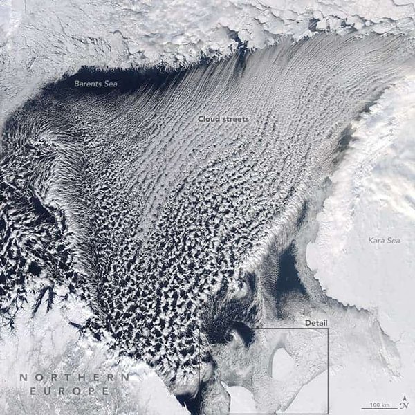
A satellite image depicting the Barents Sea, highlighting the dynamic interplay between its geography, climate, and the lasting impacts of its glacial history.
Sedimentation and Hydrocarbon Systems
Recording Geological Evolution and Resource Potential
The Barents Sea contains a thick succession of sedimentary rocks, locally exceeding 10 km, spanning from the Upper Paleozoic to the Cenozoic. This vast sedimentary record is invaluable for understanding the region's geological evolution and its hydrocarbon potential. Exploration activities in the Barents Sea date back to 1907, with significant discoveries of oil and gas fields in both Paleozoic and Mesozoic strata.
The Upper Triassic–Middle Jurassic Realgrunnen Subgroup is currently the most prolific reservoir package in the southwestern Barents Sea, hosting major hydrocarbon accumulations in fields such as Goliat, Snøhvit, Johan Castberg, and the Wisting discovery. Sediment supply variations played a critical role in the development of these systems.
Key Geological Events and Their Impact on the Barents Sea
| Geological Era/Period | Major Tectonic Events | Resulting Geological Features | Impact on Barents Sea |
|---|---|---|---|
| Late Neoproterozoic-Cambrian | Timanian Orogeny (collision of Arctida and Fennoscandia) | WNW-ESE structural trends | Initial basement structuring in the southern Barents Sea. |
| Mid-Paleozoic (Caledonian Orogeny) | Collision of Baltica and Laurentia (forming Laurasia) | Caledonian nappes and thrust sheets, metamorphic basement | Formation of the foundational crustal fabric; extensional collapse in Devonian. |
| Late Devonian - Early Carboniferous | Svalbardian phase; extensional collapse of Caledonian orogen | Major rift zones, initial basin development | Start of widespread extensional tectonics; formation of significant grabens. |
| Middle Carboniferous - Permian | Regional subsidence; formation of Permian-Triassic sag basin | Thick sedimentary successions, salt mobilization | Deepening of basins; creation of accommodation space for sediment. |
| Late Mesozoic (Jurassic-Cretaceous) | Rifting, basin formation, shifting tectonic activity | Tromsø Basin development, Senja Ridge, Veslemøy High | Continued extensional phase; deposition of thick Mesozoic sediments; key for hydrocarbon reservoirs. |
| Early Tertiary (Paleocene-Eocene) | Rifting and opening of Norwegian-Greenland Sea; continental breakup | Sheared continental margin, significant uplift and erosion | Transition to passive margin; major uplift events affecting burial and hydrocarbon systems. |
| Late Cenozoic (Quaternary) | Quaternary glaciation, post-glacial rebound | Glacial erosion, deposition of tills, uplifted glaciomarine sediments | Extensive erosion and deposition; shaping of present-day seafloor and coastline. |
Ongoing Geological Understanding and Future Exploration
An Active Frontier for Research
Despite extensive research and exploration, the crustal architecture and tectonic evolution of the Barents Sea remain subjects of active scientific debate due to its complex history. New aeromagnetic data, seismic reflection profiles, and detailed basin modeling continue to refine our understanding of this intricate region. The integrated knowledge from Russian and Norwegian institutions is crucial for advancing the geological maps and paleogeographic reconstructions that illustrate the Barents Sea's evolving landscape from the Early Devonian to Eocene times.
The Barents Sea continues to represent an exploration frontier, not only for hydrocarbons but also for understanding fundamental geodynamic processes, such as how mountain ranges evolve in rifted continental domains and ultimately lead to nascent oceans. The ongoing study of its tectonic setting and lithospheric structure, including its isostatic state and gravity field, provides vital insights into the Earth's dynamic systems.
Frequently Asked Questions
What is the primary tectonic process that shaped the Barents Sea after its initial formation?
How has glaciation influenced the Barents Sea's geology?
What are the main structural elements of the Barents Sea?
Why is the Barents Sea important for hydrocarbon exploration?
Recommended Further Exploration
- Explore the broader geological evolution of the Arctic Ocean and its marginal seas.
- Investigate the impact of Quaternary glaciation on continental shelves globally.
- Delve into the hydrocarbon potential of rift basins and their formation mechanisms.
- Understand the plate tectonic reconstructions related to the breakup of Pangaea.
References
Last updated May 21, 2025