
Landslide Risk Mapping: An In-Depth Exploration
Discover the latest methodologies, applications, and research insights into landslide risk mapping
Key Highlights
- Advanced Techniques Integration: Combining machine learning, GIS, and remote sensing for robust risk maps.
- Comprehensive Risk Assessment: Assessing probabilities, vulnerabilities, and exposure for effective hazard management.
- Interdisciplinary Collaboration: Uniting geology, geography, computer science, and decision-making methodologies to improve accuracy.
Understanding Landslide Risk Mapping
Landslide risk mapping is a pivotal component of disaster preparedness and sustainable land use planning that aims to forecast and mitigate the societal and economic effects of landslides. This process involves combining various datasets, methodologies, and technologies to assess both the likelihood of landslide occurrences and the potential impact on communities and infrastructure.
What is Landslide Risk Mapping?
At its core, landslide risk mapping involves pairing the probability of landslide events with the expected losses in terms of human life, property, and infrastructure. This approach goes beyond merely determining areas of high landslide susceptibility; it integrates hazard identification with vulnerability and exposure assessments to provide a comprehensive view of risk. The process is essential for land-use planning, emergency response planning, and hazard mitigation.
Components of Risk Mapping
Different studies and approaches break down the process of landslide risk mapping into several fundamental components:
- Hazard Assessment: Determining areas where landslides are likely to occur by analyzing geological, hydrological, and climatic data.
- Vulnerability Analysis: Evaluating how susceptible the local community, buildings, and infrastructure are to landslide impacts.
- Exposure Evaluation: Assessing what is at risk, including population density, infrastructure networks, and economic assets.
- Risk Integration: Combining the likelihood of occurrence with potential damage to create a comprehensive risk index for each area.
Methodologies in Landslide Risk Mapping
A variety of methodologies are employed to develop robust landslide risk maps. Recent trends in the field emphasize data integration, advanced computational models, and the use of cutting-edge technologies.
Advanced Technologies and Techniques
Machine Learning and Deep Learning
Modern studies have increasingly applied machine learning and deep learning algorithms to improve landslide susceptibility models. These techniques analyze large datasets comprising climatic conditions, soil types, slope angles, and historical landslide occurrences. By learning complexities in data patterns, these models can produce highly accurate predictions of landslide-prone areas.
Advanced models are capable of identifying subtle correlations between multiple variables, enabling the creation of predictive maps that support both near-real-time assessments and long-term risk forecasts.
Geographic Information Systems (GIS) and Remote Sensing
GIS plays a central role in landslide risk mapping by integrating various spatial datasets. When combined with remote sensing technologies, high-resolution satellite images and aerial surveys offer valuable insights into terrain and vegetation cover. These data sources are used to develop landslide inventories and identify predisposing factors such as slope morphology and land cover.
Remote sensing also provides real-time monitoring capabilities, helping to validate predictive models and refine assessment methodologies. The combination of these advanced spatial tools ensures that risk maps remain updated with the latest environmental changes.
Statistical and Probabilistic Models
Alongside modern algorithms, traditional statistical models and probabilistic frameworks continue to guide landslide risk assessment. These methods often incorporate historical data and environmental variables to gauge the likelihood of landslide events. Techniques such as the weight-of-evidence method allow researchers to quantify the influence of multiple factors, ensuring that their models are both rigorous and validated.
By employing a combination of semi-quantitative, quantitative, and multi-criteria decision-making approaches, statisticians can build scaled models capable of predicting risk with increasing levels of accuracy.
Recent Trends and Research Directions
Research in landslide risk mapping continues to evolve, embracing innovative approaches and new technologies. Current trends are focused on enhancement of map accuracy through data integration and interdisciplinary methods.
Integration of Data Sources
Combining Historical and Real-Time Data
One of the significant advancements in landslide risk assessment is the combination of historical landslide data with real-time monitoring from satellites and sensors. This integration allows researchers to capture dynamic environmental changes that may affect slope stability, such as fluctuating rainfall patterns or human-induced land modifications.
Such hybrid approaches enhance the predictive capacity of risk maps, making them instrumental for disaster management and urban planning.
Object-Oriented Mapping and Interdisciplinary Approaches
Object-oriented mapping leverages principles from computer science and spatial analysis to assess landslide risks effectively. By segmenting land surfaces into individual objects with specific properties, this method enables more detailed investigations of spatial and temporal relationships affecting landslide occurrences.
Interdisciplinary collaborations, involving experts in geology, meteorology, engineering, and data science, have led to the development of sophisticated models such as the Landslide Object-Oriented Model (LOOM). These collaborations ensure that maps are not only scientifically robust but also practically applicable in risk management scenarios.
Validation and Uncertainty Management
Validation of Risk Maps
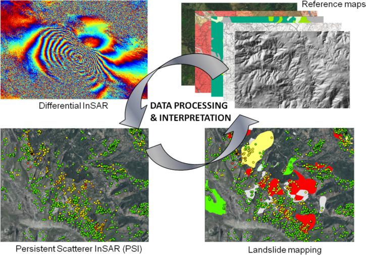
The credibility of landslide risk maps is enhanced through rigorous validation processes. Researchers often use freely available datasets along with techniques like Interferometric Synthetic Aperture Radar (InSAR) to validate ground deformation and confirm model predictions. Validated maps offer greater confidence to policymakers, urban planners, and disaster response teams.
Integration of hazard, vulnerability, and exposure in risk assessments contributes to a more nuanced understanding of uncertainties, enabling more effective planning and resource allocation.
Quantitative vs. Qualitative Approaches
Quantitative risk models provide numerical estimates of landslide probabilities and expected losses, whereas qualitative assessments rely on expert judgment and heuristic approaches. Recent studies suggest that a combined approach leveraging both quantitative and qualitative data yields the most comprehensive risk maps. This dual methodology supports fine-tuning of models and better representation of real-world complexities.
Applications and Practical Implications
The practical applications of landslide risk mapping extend across disaster management, urban planning, and environmental protection. These maps are essential tools for mitigating risks, guiding infrastructure development, and planning emergency response strategies.
Urban Planning and Infrastructure Development
Strategic Land Use and Zoning
Landslide risk maps are foundational in informing land use decisions. Urban planners rely on these maps to identify safe areas for construction and to design urban growth strategies that factor in the potential for landslide occurrences. By incorporating risk maps into planning processes, municipalities can reduce the exposure of vulnerable populations and assets.
Strategic zoning based on risk assessments also forms the basis for long-term sustainable development plans.
Disaster Preparedness and Mitigation
Governments and emergency management agencies use landslide risk maps to develop hazard mitigation strategies. These maps provide critical input for designing early warning systems, developing evacuation plans, and implementing mitigation measures such as slope stabilization and drainage improvements.
Customized risk maps for specific regions enable a targeted approach, ensuring that resources and attention are allocated where they are most needed.
Environmental and Economic Impact Assessments
Assessing Economic Losses
A crucial aspect of landslide risk mapping is the evaluation of potential economic impacts. Detailed risk maps aid in estimating both direct financial losses (e.g., property damage and infrastructure repair costs) and indirect impacts (e.g., business interruptions and loss of public services). This comprehensive analysis assists government bodies and insurance companies in planning responses and allocating funds for risk reduction initiatives.
Further, a refined risk mapping process supports cost-benefit analyses of various mitigation strategies, guiding investments that yield the highest risk reduction returns.
Conservation and Land Management
Beyond urban environments, landslide risk maps are vital for managing rural and ecological landscapes. Conservationists and land managers use these maps to maintain ecosystem services, identify high-risk areas for potential intervention, and plan restoration efforts in degraded or vulnerable slopes.
In regions where natural landscapes are vital for tourism or agricultural productivity, integrating risk mapping into management plans helps protect both natural resources and community livelihoods.
Comparative Overview: Technologies, Methods, and Outcomes
| Aspect | Description | Technologies/Methods | Impact |
|---|---|---|---|
| Hazard Assessment | Identifying areas prone to landslides through analysis of terrain, weather, and geological data | GIS, Remote Sensing, Statistical Models | Improved prediction and risk identification |
| Machine Learning | Application of algorithms for model training and predictive analysis based on historical data | Deep Learning, AI Algorithms | Enhanced accuracy of susceptibility mapping |
| Validation Techniques | Cross-checking map predictions with real-time data | InSAR, Field Surveys, Open-source Datasets | Increased reliability and confidence in maps |
| Risk Integration | Combining hazard, vulnerability, and exposure to produce comprehensive risk assessments | Multi-criteria Decision Making, Weight-of-Evidence Methods | Effective planning for mitigation strategies |
This table summarizes the various technological approaches, methodologies, and their impacts within the field of landslide risk mapping. The integrated approach outlined here aims to combine the strengths of each method to produce sophisticated and reliable risk assessments.
References
The research and methodologies discussed herein are supported by a range of trusted sources. These selected articles and studies provide further detail on landslide risk mapping techniques and applications:
- Landslide inventory, susceptibility, hazard and risk mapping - ResearchGate
-
Machine learning and deep learning-based landslide susceptibility mapping - ScienceDirect
- U.S. Landslide Inventory and Susceptibility Map - USGS.gov
- Regional-scale landslide risk assessment in Central Asia - Copernicus
-
A review of landslide hazard assessment techniques - NCBI
Recommended Further Exploration
Last updated March 12, 2025